The eastern Pacific remains active, with 2 named storms churning and a 3rd area of interest developing near Mexico, while the Atlantic is still devoid of organized tropical activity. Post-tropical storm Bonnie and tropical storm Darby are still expected to track west into open waters of the Pacific Ocean, with the latter expected to reach hurricane strength over the next couple days. The Atlantic Ocean, on the other hand, is still remaining hostile for tropical storm development, with only disorganized showers and thunderstorms being present.
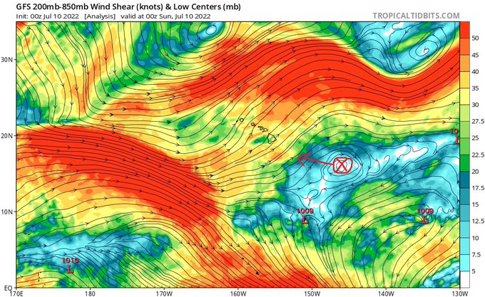
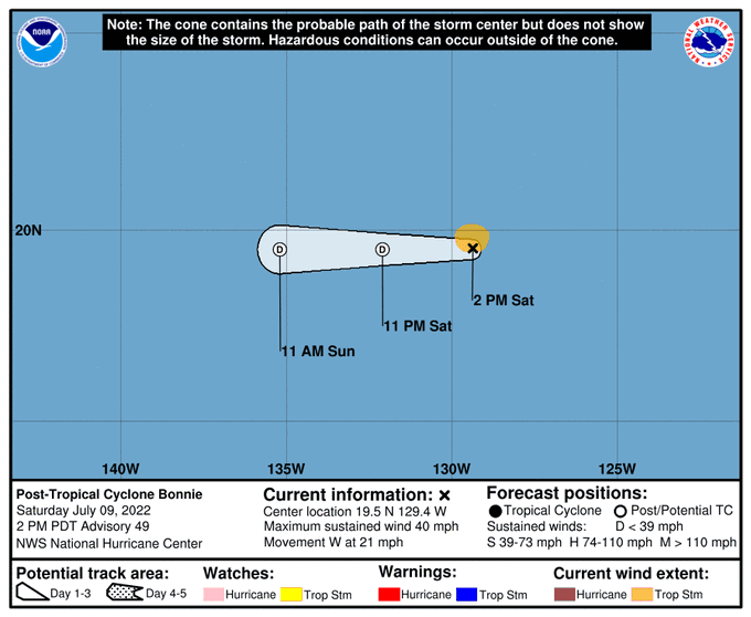
Post-Tropical storm Bonnie continues to slowly make its way westward towards the open waters central Pacific Ocean, with maximum sustained winds of 40mph (as of 2:00pm PDT Monday, July 9th) . It is forecasted to continue weakening as it approaches Hawaii, due to encountering high upper-level wind shear in place over the central Pacific. The impacts for the Hawaiian Islands at this time are increased, potentially heavy rainfall.

Tropical storm Darby is also making its way westward into the open waters of the Pacific Ocean with maximum sustained winds of 45mph (as of 9:00pm MDT Monday, July 9th). Unlike Bonnie, Darby is eventually forecasted to reach hurricane strength over the next couple days. At the moment, impacts from Darby will remain limited as it will mainly traverse over open waters.
Another low over western Mexico (area 1) is also slated to move off into the Pacific Ocean over the coming days, however, it is not expected to become organized at this time.

On the other side in the Atlantic Ocean, things will continue to remain quiet for the near future. Dry air and high upper-level wind shear continues to suppress and discourage organized tropical development. Of note, an area of low pressure (area 2) is currently over Cuba and is expected to move northwest towards the Gulf of Mexico and eventually the southern US.
While possibly not reaching any level of tropical storm organization, it is at least going to help bring increased potential for rainfall across the gulf coast states. Further east, another area of low pressure (area 3) is making its way westward towards the Caribbean. This low will be steered around the area of high pressure off to its north and west and is also not anticipated to organize due to dry Saharan air and high upper-level wind shear.


