Hello all and happy Sunday! I hope the weekend has been well and that the heat hasn’t caused too many issues over the past week. Today we will look at a 3-day southeast forecast to see what you can expect over the general area.
For the day today, the expectation is for temperatures to be highest throughout Texas with high temperatures remaining in the low to mid 100s. As you move east, the descent of a front as well as more northerly flow aloft will allow for cooler temperatures closer to the mid 90s.

Since Texas is closer to the upper-level ridge axis as compared to the more eastern portions of the southeast, their temperatures will remain higher since they don’t get exposed to as much of the northerly flow and shower activity as portions of Mississippi, Alabama, Tennessee, and Georgia.
Due to this heat expected in Texas, the NWS has issued heat advisories and excessive heat warnings where heat indices will remain elevated throughout the day today.

For the day today, the NWS is likely to stick with a heat advisory for Texas, where heat indices are expected to remain high but not as high as Saturday. In addition, the heat advisory is expected to remain through Louisiana and portions of southwestern Mississippi throughout the day today until the evening.
Moving towards precipitation, most of the precipitation is expected closer to the descending frontal boundary and further away from the upper-level ridge situated over northern Texas.

The WPC outlook for today shows the chance for more general showers and thunderstorms throughout much of the southeast region, with heavier rain and flooding possible throughout the coast of Georgia and South Carolina.
Tomorrow
Looking towards Monday, the main high-pressure system out to the west will continue to influence the southeast with the axis extending out towards Tennessee and Kentucky.

With the frontal boundary pushing through the southeast on today and making its way out over the Gulf coast on Monday, this allows for much of the heavier precipitation for the day to be featured over the very southern portions of Louisiana, Mississippi, and Alabama.


As the map above shows, the front that will be stalled over the southeast near the Gulf will provide the chance for enhanced shower and thunderstorm activity that is likely to affect locations right on coast, with the potential for localized amounts of 1″. However as the map shows, a lot of the heavier precipitation will remain over the water.
Temperatures on Monday are expected once again to remain the highest over Texas, where the lack of precipitation and clouds thank to the mentioned upper-level ridge will allow temperatures to exceed 100F. For the rest of the southeast, expect temperatures to remain in the low to mid 90s and cooler as you head towards Georgia and South Carolina.

Tuesday
For Tuesday, the story gets a little more interesting with the ridge continuing the stay over the west with an upper-level low continuing to remain just off of the Gulf coast.

With the formation of an upper-level low out over the Gulf, this would allow for precipitation to be heaviest over Gulf states in areas closest to the coastline, where the effects from the system would be the highest. Compared to yesterday, the models are also showing a greater chance at higher amounts closer to land.
Both the American and European ensemble models pick up on this formation, and show 24-hr precipitation amounts from Tuesday morning through Wednesday morning exceeding 1″ close to 1.5″ along the immediate coastline.


The American ensemble brings the heavier rainfall amounts a little closer into Louisiana, however both models do show the chance for notable precipitation for Tuesday into Wednesday along the Gulf coast. While the NHC is not currently monitoring this system for any sort of amplification in the Gulf, this will be something to monitor as we get closer to Tuesday to see where this system will eventually travel to.
Temperatures on Tuesday are expected to mostly remain consistent with Sunday and Monday. With the level-ridge still situated out west, the temperatures will be highest in Texas.
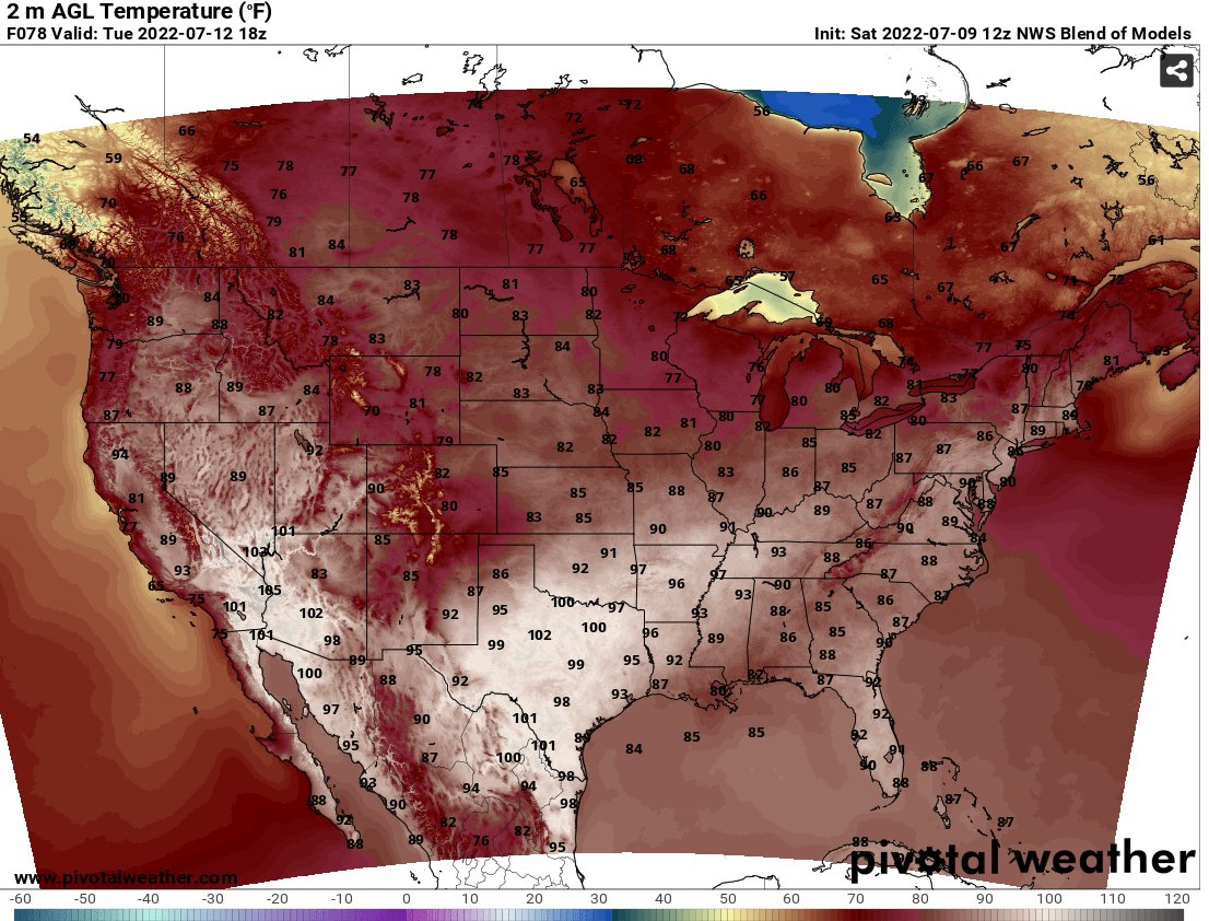
Expect temperatures close to or just above 100F in Texas, with temperatures closer to 90F throughout the rest of the southeast.
3-Day Southeast City Forecast
| Dallas, TX | ||
| Sunday | Monday | Tuesday |
| High: 103F | High: 105F | High: 105F |
| Low: 81F | Low: 81F | Low: 80F |
| Precip: None | Precip: None | Precip: None |
| Houston, TX | ||
| Sunday | Monday | Tuesday |
| High: 101F | High: 99F | High: 95F |
| Low: 79F | Low: 80F | Low: 79F |
| Precip: 20% | Precip: 30% | Precip: 40% |
| New Orleans, LA | ||
| Sunday | Monday | Tuesday |
| High: 91F | High: 89F | High: 84F |
| Low: 77F | Low: 76F | Low: 76F |
| Precip: 80% | Precip: 80% | Precip: 80% |
| Little Rock, AR | ||
| Sunday | Monday | Tuesday |
| High: 92F | High: 96F | High: 99F |
| Low: 72F | Low: 74F | Low: 76F |
| Precip: None | Precip: None | Precip: None |
| Memphis, TN | ||
| Sunday | Monday | Tuesday |
| High: 93F | High: 97F | High: 100F |
| Low: 71F | Low: 75F | Low: 76F |
| Precip: None | Precip: None | Precip: None |
| Birmingham, AL | ||
| Sunday | Monday | Tuesday |
| High: 88F | High: 90F | High: 89F |
| Low: 73F | Low: 73F | Low: 73F |
| Precip: 60% | Precip: 30% | Precip: 40% |
| Atlanta, GA | ||
| Sunday | Monday | Tuesday |
| High: 86F | High: 82F | High: 87F |
| Low: 70F | Low: 71F | Low: 72F |
| Precip: 50% | Precip: 30% | Precip: 50% |


