Cloudy, reary, damp weather is here to stay this week. Right now, it looks like we may be stuck in a cloudy pattern for the next few days with a few pokes of sunshine here and there, but mainly cloudy.
It will feel more like Seattle than South Mississippi.
The good news is that with all of the cloud cover and hit and miss chances for showers, the threat for severe weather looks to be pretty low. By Thursday that may change, but even then, things are looking pretty low-end and conditional.
Aside from that, we have a south wind, some clouds and some patchy fog. Speaking of wind, I got a request recently for wind speed and direction for the area. So I put the info in a handy chart.
The lines correspond to the axis on the left and the bar chart to the axis on the right. The line chart tells you the wind speed and peak wind gusts while the bar chart tells you which direction the wind is coming from.
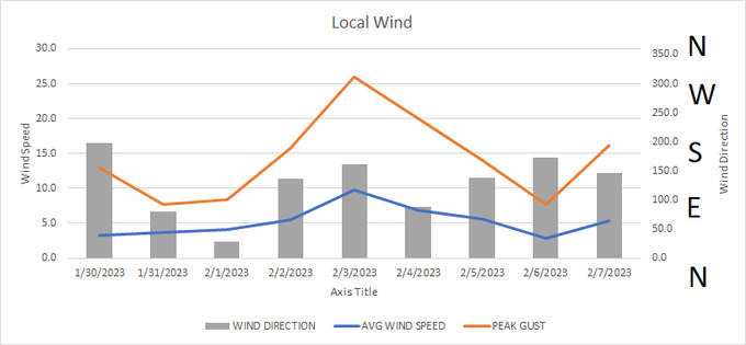
Data show that we will flip our wind to the north tomorrow and the day after but then turn it back around to the south for the rest of the week. The breeziest day will be Friday.
REGIONAL DAY TO DAY FORECAST
Today
Mostly cloudy. Patchy fog this morning. A few showers possible today. Highs in the lower 70s. West winds around 5 mph, becoming north this afternoon. Chance of rain 20 percent.
Tonight
Cloudy with a 20 percent chance of showers. Patchy fog after midnight. Lows around 60. Northeast winds around 5 mph.
Tuesday
Cloudy. Patchy fog in the morning. A slight chance of showers in the afternoon. Highs around 70. North winds around 5 mph. Chance of rain 20 percent.
Tuesday Night
Cloudy. Lows in the lower 50s. North winds around 5 mph.
Wednesday
Cloudy. Highs in the mid 60s. Northeast winds around 5 mph.
Wednesday Night
Cloudy. Lows in the mid 50s.
Thursday
Cloudy with more rain possible. Highs in the lower 70s. Chance of rain 60 percent.
Thursday Night
Cloudy with rain continuing. Cooler with lows in the mid 40s. Chance of rain 60 percent.
Friday
Clearing skies and drying out. Highs in the upper 50s.
Friday Night
Mostly clear. Cooler with lows in the mid 30s.
Saturday
Sunny. Highs in the lower 60s.
Saturday Night
Partly cloudy in the evening, then becoming mostly cloudy. Lows in the lower 40s.
Sunday
Mostly cloudy. Highs in the mid 60s.


