The cool and moderated weather is absolutely welcome, and should continue over the next week!
Could we have seen our last glimpse of summer? We can’t say that yet, but the pattern that we’re getting into is very cool and very wet. With daily high temperatures in the 80s for the next week, and pretty high rain chances, it’s going to be a different feel from summer.
Specifically, today we’re looking at high temps in the upper-80s. One of the warmer days in the week, we still are going to continue to cool off.

The NWS forecast shows Natchez at around 87F, with many areas around that if not cooler. The main reason is due to the increased storms that are going to be occurring across the region.

The HRRR computer model shows widespread thunderstorms developing tomorrow afternoon, essentially cutting off the diurnal heating cycle.
Synoptically, looking at the big picture, the reason we’re seeing this unusual weather is because of a large longwave trough over the Eastern United States.

Right now, the core of the upper level low is over Iowa and the Great Lakes region, with troughing across much of the Eastern US. There is a ridge built up across Florida and the Gulf Coast, but we’re going to be seeing the influence of the cooler and wetter trough over the next few days.

The bulk of the cooler air hasn’t reached this area yet, and is really centered over the Midwest and the Southwest. During the week that cooler air will slide into this region as the troughing deepens.
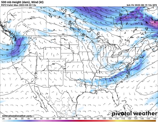
Looking at the 500 mb charts for Monday, that trough is a lot deeper than it was, and the cooler air is a lot closer to this region. In addition, the trough is acting as a boundary between the warmer and cooler air. On the south side of the boundary, we have excessive moisture, with PWAT values shooting up to over 2”.

With a boundary slowly lingering through the area, and high PWAT values, heavy rain is going to be a real concern. These slow-moving boundaries have become a hallmark of the past few weeks, and this is just one more example of what we’ve been seeing.
The upper-level pattern is going to be more favorable for rain tomorrow and Monday, so I fully expect to see the highest rain chances then, as opposed to today. The upper-level flow is going to be much stronger than usual over the summer, so we also might have to keep an eye out for strong thunderstorms, but given the cooler temperatures, severe weather isn’t expected.

With the moisture levels being very high, and heavy rain occurring, we are expected to see close to 2-3” of rain over this next week. Some areas are currently waterlogged and can’t take much more rain, so we’re going to have to be watchful for some localized flooding, as has been the case lately.
Day-by-Day Forecast
Today
Mostly cloudy, with a 70-percent chance of afternoon thunderstorms. Highs in the upper-80s.
Tomorrow
Mostly cloudy, with a 60-percent chance of afternooon thunderstorms. Highs in the mid-80s.
Monday
Cloudy, with an 80-percent chance of rain and thunderstorms. Some heavy rain is possible. Highs in the low-80s.
Tuesday
Cloudy, with an 80-percent chance of rain and thunderstorms. Some heavy rain is possible. Highs in the low-80s.
Wednesday
Mostly cloudy, with a 60-percent chance of afternoon thunderstorms. Highs in the low-80s.
Thursday
Partly cloudy, with a 60-percent chance of afternoon thunderstorms. Highs in the mid-80s.
Friday
Partly cloudy, with a 50-percent chance of afternoon thunderstorms. Highs in the mid-80s.


