There are signs of life for the 2022 Atlantic Hurricane Season with an area of investigation moving into the Bay of Campeche and a tropical wave emerging off the coast of Africa. No significant impacts to the U.S. from these features are expected at this time.
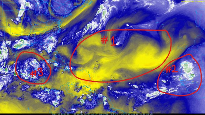
1) The Saharan Air Layer (SAL) continues to keep the Main Development Region (MDR) dry and hostile towards tropical development; however, that may change shortly or at least partially as a tropical wave moistens the environment.
2) A tropical wave emerging off the coast of Africa will face the SAL head-on diminishing its chances for tropical development, but may carve the way for other tropical waves following behind it as it replaces the dry air with more favorable moisture.
3) Invest 99L has been given a 40% chance of cyclone formation within the next 2-to-5 days as it moves off of the Yucatán Peninsula and into the Bay of Campeche.

Wind shear is forecasted to be mostly favorable for the storm system during its short time over water. The storm system will generally feel wind shear values of 5-to-10 knots which will allow the storm to maintain any organization it develops.
Additionally, the upper-level winds will be conductive of surface pressure lowering further strengthening the storm as the anticyclonic/clockwise winds help the storm vent/breath.

This storm will have plenty of moisture to work with as it heads northwest and should allow for abundant thunderstorms development. There will be drier air on the northern side of the storm, but it doesn’t appear it will affect the storm much as it is forecasted to move northward out ahead of the storm.

Sea Surface Temperatures (SSTs) are about as favorable as they can get, with waters out ahead of the storm pushing 31C (88F)! The warmer the SSTs, the more unstable the atmosphere is which tends to induce higher thunderstorm activity.

The storm is generally expected to hug the eastern coast of Mexico which will not allow it to organize into a well-structured cyclone; however, if the storm develops farther north and east away from land, it will have more time over water giving it a better chance at organizing into a tropical storm. This run of the GFS anticipates a path hugging the coast with little organization before making landfall, which is the most likely scenario for how this system will play out.


