Good morning folks! Expect a couple rounds of showers and thunderstorms today with one round this morning and early afternoon followed by a small break in the heavier rain during mid-afternoon.

Later this evening more storms are expected to develop and move through the region eventually clearing up by midnight tonight. Temperatures will reach the mid 80s today with very moist dewpoints of 75F, allowing a not-so-comfortable heat index around 95F.

The subtropical ridge over the Southeast is considerably weaker than it has been compared to the majority of this summer and is allowing for near or below average temperatures for the next several days. This has also allowed for a frontal boundary to move in place over the forecast region and explains the wetter weather we’ve been experiencing the last few days. This frontal boundary is expected to remain close enough to the region that it was induce wetter weather throughout this weekend and into next week.
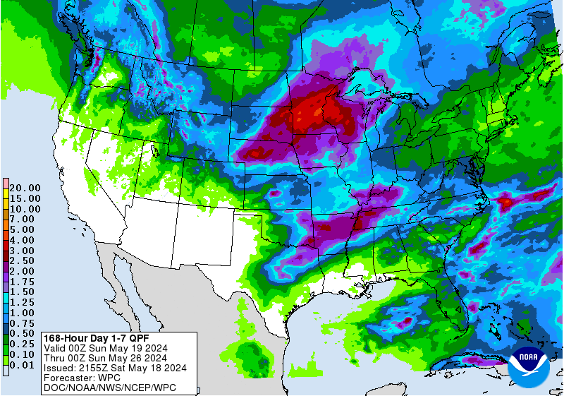
The amount of rainfall forecasted for the southern half of the U.S. is nothing short of incredible considering how it’s expected to fall on some of the most drought-stricken states. Thankfully SE MS/SW AL isn’t currently experiencing any significant drought conditions, with only a small portion of the region experiencing abnormally dry conditions; regardless, rainfall amounts ranging from 2″-3″ can be expected throughout the next 7 days with locally higher amounts exceeding 5″ possible.
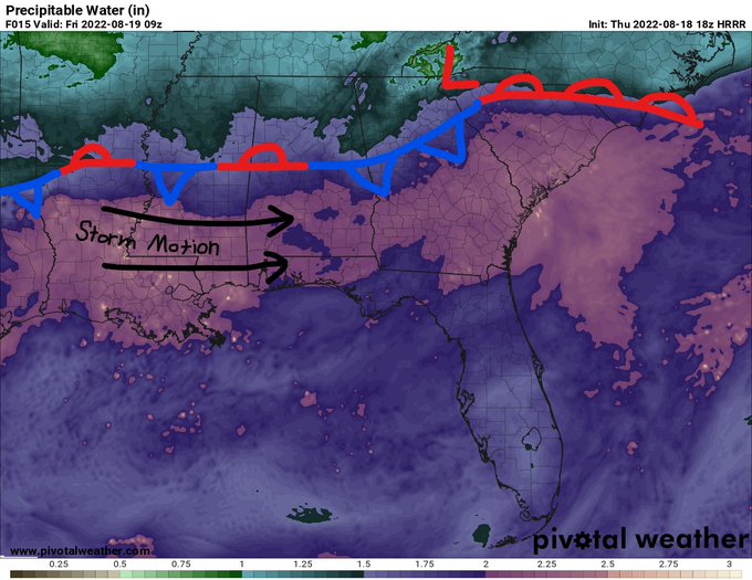
Relatively high PWAT values of 2″-2.5″ have moved into the region providing ample moisture for this morning’s showers and thunderstorms and will allow for heavy rainfall rates in the storms later this evening. These storms will generally move west to east but may cause flash flooding problems beneath any slow-moving storms. This tropical moisture is forecasted to continue allowing for heavy rainfall and higher chances of precipitation the next 7 days, keeping things cooler than normal (hooray!) but very muggy (aww).
Day to Day Forecast
Today
Patches of fog in the morning. Mostly cloudy with a 90-percent chance for showers and thunderstorms. Highs in the mid 80s. Heat Index values around 95F.
Tonight
Mostly cloudy with a 60-percent chance for showers and thunderstorms before midnight. Lows in the lower 70s.
Saturday
Mostly cloudy with an 80-percent chance for showers and thunderstorms. Highs in the lower 90s. Heat Index values around 102F.
Saturday Night
Mostly cloudy with a 60-percent chance for showers and thunderstorms before midnight. Lows in the mid 70s.
Sunday
Mostly cloudy with a 70-percent chance for showers and thunderstorms in the afternoon/evening. Highs in the upper 80s. Heat Index values around 99F.
Sunday Night
Mostly cloudy with a 60-percent chance for showers and thunderstorms before midnight. Lows in the lower 70s.
Monday
Mostly cloudy with a 70-percent chance for showers and thunderstorms in the afternoon/evening. Highs in the mid 80s.
Monday Night
Mostly cloudy with a 70-percent chance for showers and thunderstorms. Lows in the lower 70s.
Tuesday
Mostly cloudy with an 80-percent chance for showers and thunderstorms. Highs in the mid 80s.
Tuesday Night
Mostly cloudy with a 60-percent chance for showers and thunderstorms. Lows in the lower 70s.
Wednesday
Mostly cloudy with an 80-percent chance for showers and thunderstorms. Highs in the mid 80s.
Wednesday Night
Mostly cloudy with a 40-percent chance for showers and thunderstorms. Lows in the lower 70s.
Thursday
Partly cloudy with a 70-percent chance for showers and thunderstorms in the afternoon/evening. Highs in the mid 80s.
Thursday Night
Mostly cloudy. Lows in the lower 70s.


