Remember how I said, “around Thanksgiving” was the likely going to be our first shot of real cold air? I think the first time I said that was back around Election day. I made a post about it the following week.
You may have heard me, on TV during the last week, talking about when our actual cool down arrives. I keep saying “late…
Posted by Nick Lilja WDAM on Tuesday, November 10, 2020
Model data continues to catch up. It looks like a reasonable cool down and a – brief – reprieve from humidity – may be in the works as we close out November and move into December.
Model Data
Here is. a look at the ECMWF model data for late Monday night (the Monday after Thanksgiving) showing lingering rainfall and a single splotch of rain/snow mix for a single data point.

What does this mean? It doesn’t mean snow is likely. Nor does it mean an actual rain/snow mix is likely either.
This is the model struggling to resolve what will happen at the surface given a reasonable push of cold air that is set to fill in behind this weekend’s potential rainfall.
For now, the forecast will continue to feature an end to the potential for showers on Sunday, and then a pretty decent cooldown as we head into next week, the beginning of December.
That cold air will likely be short-lived. But the cooldown may stick around.
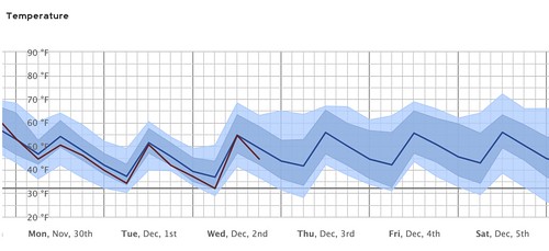
That data is from the ECMWF Ensembles. It shows that temperatures between 40F and 60F may stick around through December 5th.
The American model data, the GEFS, also an ensemble model, shows a similar trend.

What does this mean for me, Nick?
It means a cool down is coming. And that cool down is looking more and more likely. And a “cool down” in November and December often means a frost and can mean a potential freeze. Perhaps even a hard freeze. So if you have plants you’d like to protect, here is an early ‘heads up’ to get all of your options in line.
How cold, though?
We don;t know yet. Still too early for specifics. But it does look like the 20s and 30s will be possible.
But what about severe weather? Doesn’t that always happen before cold?
Severe weather doesn’t look as likely for the entire area, given the track of the system set to move through and bring the cold air with it. However, there is the chance for some severe weather. And it will depend on the final track of the system.
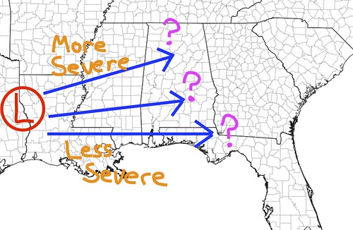
And we won’t have a better handle on that until we get past Thanksgiving Day.
The Timeline & Bottom Line
There is still a lot of shake out from the data in the coming days. I wouldn’t plan on some ‘Catastrophic Cold of Abominable Arctic Blast’ but it will be cooler as we move into December. Perhaps much cooler.
The timeline for the cooldown looks to be between November 30th and December 5th. It may feature a frost or freeze. Perhaps for multiple nights.
The cooldown may bring with it a chance for some storms – some potentially severe – but we are still monitoring that potential threat. Those storms would pass through November 28th through November 30th.
But again, there is still a lot to hammer out.
Today’s Severe Risk

Today’s Tornado Risk

Search the site


