*** 400PM UPDATE FROM NHC***
BULLETIN
Potential Tropical Cyclone Fourteen Advisory Number 1
NWS National Hurricane Center Miami FL AL142018
400 PM CDT Sat Oct 06 2018…DISTURBANCE GETTING BETTER ORGANIZED OVER THE NORTHWESTERN CARIBBEAN SEA…
…WARNINGS AND WATCHES ISSUED FOR PORTIONS OF WESTERN CUBA AND THE YUCATAN PENINSULA..SUMMARY OF 400 PM CDT…2100 UTC…INFORMATION
———————————————-
LOCATION…18.0N 86.6W
ABOUT 175 MI…280 KM S OF COZUMEL MEXICO
ABOUT 290 MI…470 KM SSW OF THE WESTERN TIP OF CUBA
MAXIMUM SUSTAINED WINDS…30 MPH…45 KM/H
PRESENT MOVEMENT…NW OR 325 DEGREES AT 6 MPH…9 KM/H
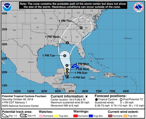
MINIMUM CENTRAL PRESSURE…1006 MB…29.71 INCHESAt 400 PM CDT (2100 UTC), the disturbance was centered near latitude 18.0 North, longitude 86.6 West. The system is moving toward the northwest near 6 mph (9 km/h). A motion toward the north is expected during the next couple of days. On the forecast track, the center of the disturbance should move near the eastern coast of the Yucatan Peninsula of Mexico tonight through Sunday night, and then move into the southern Gulf of Mexico on Monday.
Maximum sustained winds are near 30 mph (45 km/h) with higher gusts. Strengthening is forecast during the next couple of days, and the disturbance is expected to become a tropical depression on Sunday and a tropical storm on Sunday night.
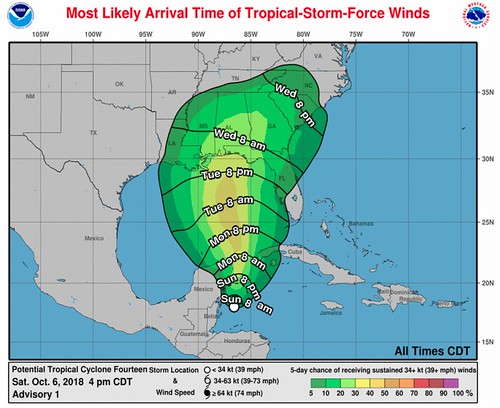
* Formation chance through 48 hours…high…80 percent
* Formation chance through 5 days…high…90 percentThe estimated minimum central pressure is 1006 mb (29.71 inches).
***ORIGINAL POST***
Invest 91L / Potential Tropical Cyclone 14 isn’t the sexiest looking tropical Invest you’ve ever seen.
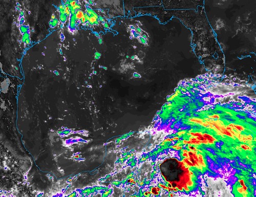
It looks a lot like a young Subtropical Storm Alberto earlier this year. Or even the beginnings of Hurricane Nate last year (at about this time, too). It is lopsided, disorganized, lacking a lot of the characteristics you’d expect of an Invest that is forecast to develop soon.
Development likely for Invest 91L in the coming days. More details about this coming up on the news at 6p! pic.twitter.com/pmeFDSnw3z
— Nick Lilja (@NickLilja) October 6, 2018
But don’t let that fool you.
It should develop in the coming 48 hours. The National Hurricane Center has given the area an 80 percent chance of developing during the next 48 hours.
Why does it look so weird?
Invest 91L / Potential Tropical Cyclone 14, a lot like Alberto and Nate, is developing from the Central American Gyre. Because of that, it will likely be a bit messier than the typical tropical waves we watch move across the Atlantic. It also means that the eventual Tropical Storm or Hurricane may also be a bit more disorganized and one-sided. A lot like Alberto and Nate, also.
Whats the latest?
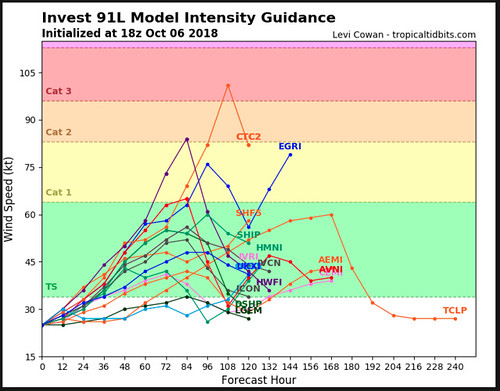
And once it does begin to organize and develop, the computer model data suggests it should strengthen into a Tropical Storm or weak Hurricane. If so, it would be named Michael.
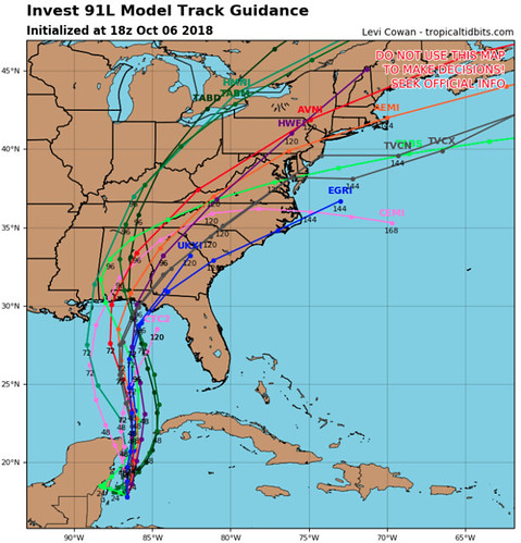
The model guidance for track shows it moving north into the Gulf and toward the Gulf Coast – somewhere between Biloxi, Mississippi and Panama City, Florida.
Do I need to worry?
Depends on your location. If you live within 100 miles of the Gulf Coast between Morgan City, Louisiana and Port St. Joe, Florida you should probably double check your Hurricane Preparedness Kit and supplies. There is still a lot we don’t know yet, but it is always best to be prepared.


