Hello everyone and welcome to another tropical update! While it is still early in the season, there is still a few important things to track and take note of, as the tropics are seeing some activity. Now with it being this early, several factors still make it unfavorable for tropical development, especially any sort of major hurricane, but its still important to track these features as even tropical storms or depressions can bring flooding and other hazards.
Of course anything is possible even with unfavorable conditions, so its always important to monitor these signs and track them carefully!
Again in this post, we will start with the NHC’s updates(s), move onto a breakdown of the current conditions in the tropics, and finish with model progressions and conclusions.
While there is no threat to the mainland US currently, it is important to keep track of these systems in the tropics and see if they will pose any future threat to us in the US. Currently, the NHC is monitoring a particular tropical wave, which has just recently left the African coast and is just south of the Cape Verde Islands.
Currently from the NHC

With this being a particular system of interest to monitor, it is time for a look at the conditions in the tropics!
Current Tropical Conditions

As of writing this post, these four regions of interest are labeled consistently with previous tropical updates from previous posts.
Disturbance 1 is currently Tropical Storm Celia, which is moving northwest currently and doesn’t pose any threat to the mainland US.
Disturbance 2 is a cluster of showers and thunderstorms over portions of Cuba and the Island of Hispaniola.
Disturbance 3 is a tropical wave currently in the Atlantic, however it is very disorganized.
Disturbance 4 is the NHC’s highlighted area of interest, and the most important feature to keep track of moving forward, as this tropical wave is being further picked up by the models as a possible storm of development. From now on throughout the rest of the post since it will be referenced many times, I will identify tropical wave / disturbance number 4 solely as “(4)”.

Looking at the upper levels at 500MB, we gain important information about the steering pattern that a system would experience. Given the two ridges in place with an upper level trough positioned in between the two ridges, a system would typically travel on the edge of the two upper-level ridges.
This would lead to the current tropical wave of interest (4) to continue to move westward towards the Lesser Antilles and eventually into the Caribbean. As we begin to look at model data further down below, we will see how these features will progress and impact the path of the tropical wave of interest (4).

Taking a look at the current wind shear across the Atlantic, we can see that much of the highest wind shear values are concentrated in the Caribbean just to the south of Cuba and Hispaniola, and into the “Northern” part of the Atlantic. A quick reminder of wind shear even though its been mentioned previously, tropical systems and hurricanes receive a negative impact from wind shear, meaning this would cause them to weaken.
Hurricanes thrive by keeping a consistent vertical structure, and wind shear disrupts this by disrupting this vertical structure, and simultaneously removing the heat and moisture they need to maintain intensity. (4) is currently located in a region of generally low shear of around ~15-20kts.

Relative humidity which gives an insight into moisture availability for a system is important since hurricanes thrive from sufficient levels of moisture. Having these higher levels of relative humidity prevents evaporative cooling, weakening the storm as this cooling process disrupts a hurricanes warm core. (4) is currently located in the right circled area, which given the deeper shaded green colors reveals that the moisture availability is sufficient to sustain tropical development.
We will see its projected path in the model guidance, however given the upper-level ridges in place, the mostly likely path of the system will be along this “belt” of higher moisture, which is denoted by the left circle.

Current sea surface temperatures across the MDR are quite sufficient for tropical development being consistently above 26C (79F). Typically 26C is considered a threshold for the minimum temperature for a tropical system to adequately develop, however temperatures closer to 30C (86F) are preferred for the more robust tropical systems and hurricanes.
The MDR known as the Main Development Region in the box, is an area where many intense hurricanes and tropical storms form, due to the large availability of warm ocean water, especially as we progress later into the season. The MDR has featured previous notable hurricanes such as Hurricane Dorian (2019), Hurricane Laura (2020), and Hurricane Irma (2017).
However, those all occurred later in the season where Atlantic waters have had much of the summer season to warm. Given we are still very early into the season, I don’t expect anything quite like the notable storms above to form at this time.

Taking a quick look at the lower levels heights and vorticity, we can see the previous identified disturbances on this image as well, with 1 being Tropical Storm Celia, and our mostly notable systems 3 and (4) being the waves out in the tropical Atlantic.
One thing that is worthy to pick out is the disturbance (4) has began to develop cyclonic or counter-clockwise rotation to it, which is an indication that the system is beginning to slightly deepen and gain more low level convergence. This low-level convergence allows for rising motion and subsequently supporting vertical development of the storm.
Model Guidance
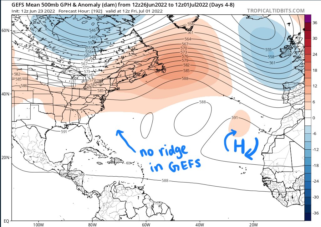

Looking at the potential upper-level steering flow, two upper-level ridges would guide the tropical system (4) along the southern portion of these ridges, moving it into the Caribbean past the Lesser Antilles and into the Caribbean Sea. The Euro model shows two prominent upper-level ridges, whereas the American model shows only one prominent upper-level ridge closer to Africa.
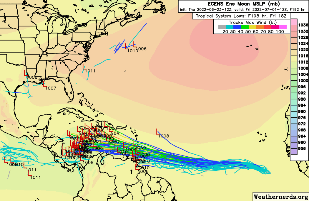
Current models offer a slightly different solution to the intensity and direction the storm (4) would take. The left Euro model is suggesting that due to the more significant ridge that would be present as noted above, the storm would be forced to take a more southern path, directed more towards the Caribbean Sea.
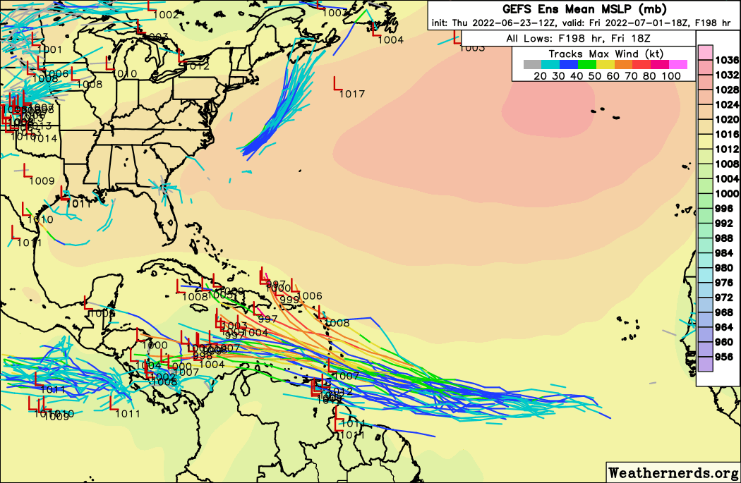
The GEFS model is showing more variability where the storm could track father north across Hispaniola or even Cuba. Keep in mind, this is all still far out in time and will likely change even as this post gets put up, so it’s best to take it with a grain of salt currently and keep checking back for future updates.
This difference is track is due to the Euro and American models showing different outcomes in terms of the upper-level steering flow. While the Euro shows a pronounced ridge centered to the north of Hispaniola, the American models show a much weaker to non-existent ridge over this same region. This will be important to look out for, as if the American model is correct, the storm could take a more northern route closer to the mainland US.
The American model is also showing the potential for a slightly stronger system, where the orange colors shows wind speeds of greater than 70kts (80mph), with the Euro staying on the weaker side with winds closer to 50kts (58mph).


Taking a look at the projected shear once this system would take a projected journey into the Caribbean, both the American and European ensembles show moderate shear values of near 20kts, with higher shear closer to the mainland US and closer to the Bahamas. This would mean a more southern path like the Euro model continues to show would support a healthier system given the lower shear values.
Conclusions
As Isaiah mentioned in the previous discussion and as I will reiterate here, all of this is subject to the system forming, which the NHC has updated to show a 60-percent chance at formation within the next 5 days. After all, it is still early in the season and getting a significant storm this early out of the Atlantic is unlikely. While global models such as the CMC, Euro, and GFS continue to come together and show a possible system forming in the Atlantic, it is still a far ways out and subject to changes as we continue to move forward throughout the coming week or so. These discussions are still important nevertheless to keep everyone informed just in case this system or any systems in the future turn out to be something serious to look out for.


