Introduction: Clouds are not just fluffy shapes in the sky; they are dynamic and essential components of our atmosphere, providing important clues about upcoming weather conditions. In Part 6 of our weather education series, we’ll explore the intriguing world of cloud formation, uncovering the different types of clouds and the fascinating processes that lead to their creation.
The Role of Clouds in the Atmosphere: Clouds are visible aggregations of tiny water droplets or ice crystals suspended in the atmosphere by vertically-moving air. They play several critical roles in meteorology and weather patterns:
- Weather Indicators: Clouds can provide clues about imminent weather changes. The type, height, and movement of clouds can signal the arrival of storms, fair weather, or even severe weather events.
- Temperature Regulation: Clouds act as a natural insulator. During the day, they block some of the Sun’s energy, helping to moderate temperatures. At night, they trap heat near the Earth’s surface, preventing rapid cooling.
How Are Clouds Formed? Clouds form through a process called condensation, where water vapor in the air transforms into tiny liquid water droplets or ice crystals. Several factors influence cloud formation:
- Moisture: To form clouds, there must be sufficient moisture in the atmosphere. This moisture can come from sources like evaporation from bodies of water or transpiration from plants.
- Cooling: Air cools as it rises in the atmosphere. This cooling can occur due to various reasons, such as orographic lifting (when air is forced to rise over mountains) or frontal lifting (when two air masses with different temperatures meet).
- Condensation Nuclei: Cloud droplets need tiny particles, known as condensation nuclei, to form around. These particles can be dust, salt, or other aerosols present in the atmosphere.
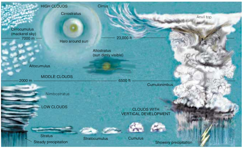
Types of Clouds: Clouds are classified into several main categories based on their appearance and altitude. Here are some of the common cloud types:
- Cirrus Clouds: High-altitude clouds that appear wispy and thin. They are composed of ice crystals and are often associated with fair weather.
- Cumulus Clouds: Puffy, cotton-like clouds that form at low to middle altitudes. They are often associated with fair weather but can grow into cumulonimbus clouds, bringing thunderstorms. We discussed altocumulus clouds previously!
- Stratus Clouds: Low-altitude clouds that appear as uniform layers, often covering the entire sky. They can bring overcast skies and light precipitation.
- Nimbus Clouds: Clouds with the term “nimbus” indicate precipitation. For example, these nimbostratus clouds from 2017.
- Cumulonimbus Clouds: Towering clouds that can extend through multiple altitudes. These are the thunderstorm clouds, often producing heavy rain, lightning, and even tornadoes.
Using Clouds as a Predictor: Because of the way each cloud is formed, it can tell you a little about how the weather may change.
- A developing deck of high clouds is a good indicator that rain is possible within 48 hours
- Tall puffy clouds on a warm summer morning is a good indicator that rain will be possible later that afternoon
- A mackerel-looking sky is a good indicator that colder, drier air is moving into the area in the lower levels
- A thunderstorm that looks green could be an indicator the storm includes hail (depending on where it is relative to the sun)
- softer-looking clouds are an indicator that there isn’t much vertical motion in the atmosphere
Take Home: Clouds are captivating and essential components of our atmosphere. They not only add character to the sky but also serve as indicators of upcoming weather conditions. By understanding cloud formation and the different types of clouds, we can gain valuable insights into the ever-changing world of meteorology.
In our next post, we’ll explore precipitation types, including the science behind rain, snow, sleet, and hail. If you have any questions or topics you’d like us to cover in this series, please feel free to reach out. Stay curious, and stay tuned for more weather insights!


