A mackerel sky this evening for some folks across the area as some altocumulus clouds drifted overhead. They did so shortly before sunset and lit up with a mix of different colors at times.
Overhead, it looked a bit less spectacular.
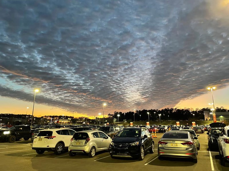
But on the ground, it looked like this….


And this…

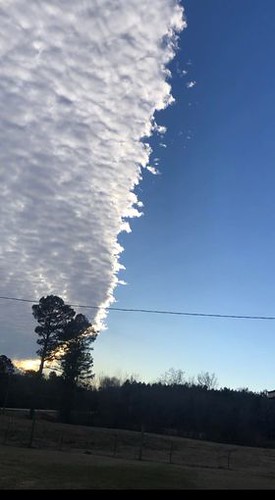
Altocumulus clouds are middle clouds, between about 5,000ft and 20,000ft up, that appear as little gray, puffy clouds. That can come as one band of clouds, or cover the whole sky. Other times, especially behind cold fronts, they can be in parallel waves or bands. Usually, one part of the cloud is shaded due to their depth. This makes one side darker than the other, which helps to separate these clouds from the higher, thinner, cirrocumulus.
Altocumulus are easy to remember because these clouds are rounded on top, and can looks like rolls are present. According to the textbook I used when I taught my severe weather class, “Altocumulus clouds that look like “little castles” (castellanus) in the sky indicate the presence of rising air at cloud level.”
There is some evidence that suggests if you see these clouds in the morning during the summer, there is a higher chance of storms that afternoon. But in winter, it usually means the air aloft is cold and traveling over a warmer surface.
I wouldn’t consider these clouds rare, but if you’ve never noticed clouds that looked like these clouds today, it may have simply been their placement in the sky relative to the setting sun that made them ‘pop’ a bit more!
And man, based on some of the pictures… they POPPED!


Part of the reason they stand out so well at sunset it the same reason why they are sometimes called a “mackerel sky” as the different textures of the clouds change the way the light moves. A bit like fish!

With fish, the reflection/refraction/molecules of the skin are the reason the light changes. In the atmosphere, it is a bit different, though the same principle. Given the relative distance and angle from the sun, these clouds allow the light to hit, reflect and pass through the clouds at different speeds.
You can think back to the atmospheric optics post I made a while back…
But in this case all we are using is the depth of the atmosphere to change the color of the light from the sun from ‘white’ light to more yellows, oranges and reds. the “ROY” part of ROYGBIV.

Recall that as you move from yellow to orange to red you are slowing the light down (it is losing energy). That is why at sunset the yellow looking sun in the distance changes the cloud color from white to yellow to orange to red as the light gets closer to you.
Susan’s picture above is a great example of that!
Closer to the sun farther away from you and on the horizon, the light from the sun isn’t traveling through as much of the atmosphere. And as it gets closer to you it has traveled through more air, water vapor, and other stuff’ to slow it down and make it more red!
Neat stuff!


Great read!! Thanks