For today and tonight, we’re expecting a lot of high clouds hanging around as the upper jet stream moves along the Gulf Coast. It might look like it’s going to rain, especially with those weak radar echoes, but so far, nothing’s actually hitting the ground here.
Later today, there’s a slight chance we might get some light showers, but with the air being pretty dry, I wouldn’t count on much rain making it to the ground then either. If we do get anything, it’s most likely to be just a few sprinkles. Despite the clouds, it’ll still feel pretty warm today, and it might get even warmer overnight in some spots with a good southerly flow returning.
Looking ahead to Saturday through next Thursday, things are going to start off quiet, but as we get closer to Christmas, rain chances will go up. We’ll see some changes in the atmosphere, with a low-pressure system and a trough moving through the area, bringing moisture with them. This means we could see some showers spreading across the region on Christmas Eve. The rain might get heavier by Christmas, with a cold front passing through, possibly bringing a few thunderstorms. The rain should start tapering off by Christmas night, though.
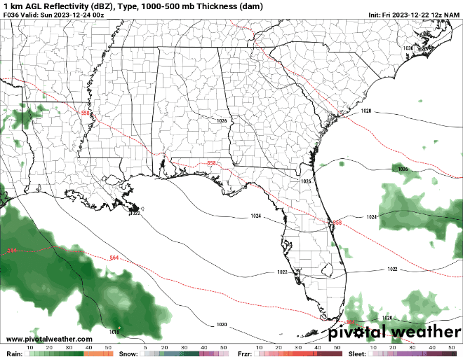
After Christmas, it looks like we’ll return to calmer, more typical weather for this time of year, at least until Thursday. There’s another cold front expected then, but right now, it doesn’t look like there is a potential for severe weather – just more regular rain.
[wpcode id=”41149″]
CHRISTMAS RAIN TIMELINE
i’ve added “thunderstorms” to the forecast, but this more for weak, elevated storms — not surface-based storms. That means while you may hear a rumble of thunder here and there, the threat for damaging wind, hail or tornadoes is very, very low.
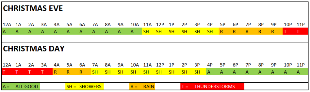
But notice that the timeline will hold a chance for some rain here and there from about 11am on Christmas Eve through about 4p on Christmas Day.
[wpcode id=”41149″]
REGIONAL DAY TO DAY FORECAST
Friday: Mostly cloudy in the morning, then becoming partly sunny. Highs in the upper 60s. East winds around 5 mph.
Friday Night: Partly cloudy. Lows in the upper 40s. East winds around 5 mph.
Saturday: Mostly sunny. Highs around 70. East winds 5 to 10 mph.
Saturday Night: Mostly cloudy. A slight chance of showers after midnight. Lows in the mid 50s. East winds 5 to 10 mph. Chance of rain 20 percent.
Sunday: Cloudy. A chance of showers in the morning, then showers likely in the afternoon. Highs in the mid 60s. Chance of rain 70 percent.
Sunday Night: Showers with a slight chance of thunderstorms. Near steady temperature around 60. Chance of rain 90 percent.
Christmas Day: Mostly cloudy with showers and storms possible. Severe Weather is not expected. Highs around 70. Chance of rain 70 percent.
Monday Night: Mostly cloudy. A slight chance of showers in the evening. Lows around 50. Chance of rain 20 percent.
Tuesday: Mostly cloudy. Highs in the lower 60s.
Tuesday Night: Mostly cloudy. Lows in the lower 40s.
Wednesday: Partly sunny. Highs around 60.
Wednesday Night: Mostly cloudy in the evening, then becoming partly cloudy. A 20 percent chance of showers. Lows around 40.
Thursday: Mostly sunny. Highs in the upper 50s.


