Hope everyone takes a few minute to try and enjoy the Fourth of July. Even if you’re working! Take a few minutes and say, “Man, this country – even with its flaws – is still pretty cool.”
And if you have a chance to celebrate today with a BBQ or some fireworks, please be careful. I know, from working on TV for so long, that someone is bound to try something silly tonight. Just don’t let it be you. I don’t want to hear about people being hurt by trying to light off too many fireworks at one, or holding something they shouldn’t have been, or not paying attention when it mattered.
Now that we got the “Dad Talk” out of the way, the forecast is looking reasonable.
I think we will have another shot for storms today. And some of these storms may be a bit more rambunctious than yesterday, but I don’t think severe weather is in the cards. I suppose a Severe Thunderstorm Warning can’t be ruled out, but if you see one, it will be mainly for a few strong wind gusts. Things like tornadoes or big hail are very, very unlikely today.

This afternoon the sea breeze will likely fire off a handful of showers and storms that will move north along the boundary. The main threat with these storm will be brief heavy rain, lightning and gusty wind.
And if you see one of these on the horizon, its time to head inside. Hang tight for a while while it passes, then give it about 20 minutes after the last rumble of thunder to head back outside.
The heat will become more of an issue this week. As a ridge tried to take over across parts of the Plains and Rockies, we may end up on the edge of this behemoth. That means Heat Index values back above 100F.

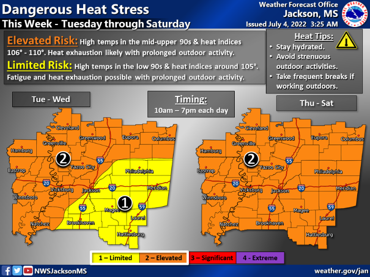
The National Weather Service in Jackson has already started messaging the potential for some dangerous heat as the ridge tries to elbow into the region.
Day to Day Forecast
Today
Passing clouds with some afternoon storms possible. Highs in the lower 90s. Chance of rain 60-percent.
Tonight
Mostly cloudy. Humid with lows in the mid 70s.
Tuesday
Partly sunny with a chance for afternoon storms. Humid with highs around 90. Chance of rain 50-percent. Heat Index around 100F
Tuesday Night
Mostly cloudy. Lows in the mid 70s.
Wednesday
Partly sunny with afternoon storms possible. Humid with highs in the 90s. Chance of rain 40-percent. Heat Index around 105F.
Wednesday Night
Mostly cloudy in the evening, then becoming partly cloudy. Lows in the lower 70s.
Thursday
Mostly sunny. A chance of showers and thunderstorms in the afternoon. Highs in the lower 90s. Chance of rain 40 percent. Heat Index around 105F.
Thursday Night
Partly cloudy in the evening, then clearing. Lows in the mid 70s.
Friday
Mostly sunny with storms possible. Highs in the mid 90s. Chance of rain 40 percent. Heat index values up to 105.
Friday Night
Partly cloudy in the evening, then clearing. Lows in the mid 70s.
Saturday
Mostly sunny with storms possible. Highs in the mid 90s. Chance of rain 40 percent. Heat index values up to 105.
Saturday Night
Mostly cloudy in the evening, then becoming partly cloudy. A chance of showers and thunderstorms. Lows in the mid 70s. Chance of rain 40 percent.
Sunday
Mostly sunny. A chance of showers and thunderstorms in the morning, then showers and thunderstorms likely in the afternoon. Highs in the lower 90s. Chance of rain 60 percent. Heat index values up to 105.
.


