As I’m writing this at 11a CDT, our radar is pretty quiet. There are a few scattered showers south of Birmingham and throughout our region, but not much else.
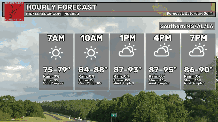
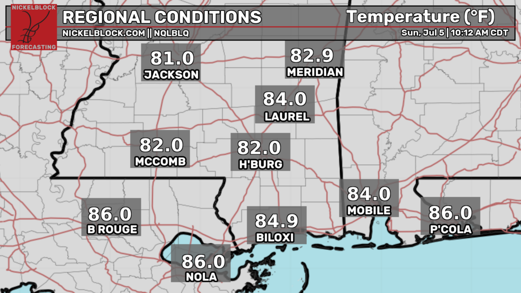
Temperatures are currently in the low-mid 80s in our region, and are expected to rise into the low-mid 90s this afternoon. Expect hotter temperatures further to the east south of Montgomery and in the Florida panhandle, and cooler temperatures in central Mississippi and central western Alabama.
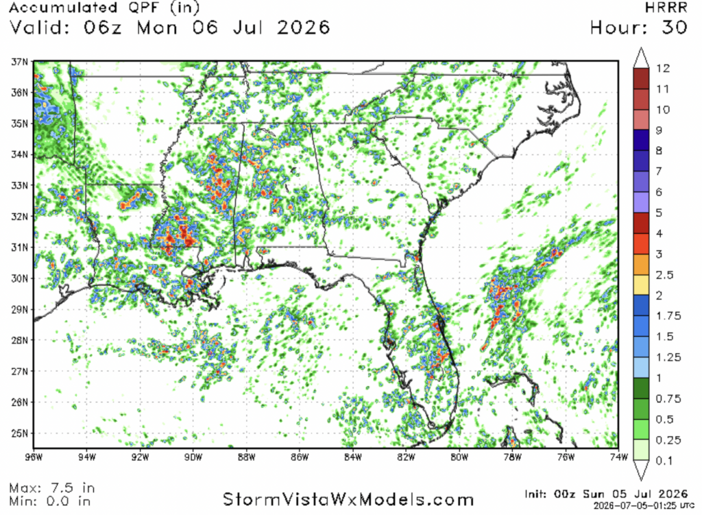
You can expect some potentially strong storms tonight that will move towards the southeast. According to the HRRR model, storms will initially develop near Jackson this afternoon and will strengthen and travel towards the coast. A bit later in the evening, storms may develop in the Birmingham area.
Rainfall totals will be very hit or miss tonight, but non coastal southwestern Mississippi (between Jackson, Natchez, and Columbia) appears to be the area likeliest to see the heaviest rain. In some places where a thunderstorm stalls, rainfall totals could exceed 4″, but most places won’t get that much.
Airport Forecast
KHOU/KIAH (Houston) – Current: temperature is 91ºF, dew point is 75ºF, skies are partly cloudy, wind is coming out of the southwest at 8 mph, and visibility is 10 miles. Tonight: there is a slight chance of storms, but skies will still be mostly clear. Very minor delays are possible.
KATL (Atlanta) – Current: temperature is 90ºF, dew point is 71ºF, skies are partly cloudy, winds are slightly gusty coming from the west at 12 mph, and visibility is 10 miles. There is a chance of storms between 4 and 10 tonight, but they will likely be minor. Minor delays are possible.
KMSY (New Orleans) – Current: temperature is 89ºF, dew point is 78ºF, skies are mostly cloudy, winds are coming out of the northwest at 8 mph, and visibility is 10 miles. There is a chance of storms between 3 and 10 pm. Some delays are possible.
KBTR (Baton Rouge) Current: temperature is 88ºF, dew point is 76ºF, skies are partly cloudy, winds are coming out of the west at 8 mph, and visibility is 10 miles. There is a chance of storms between 2 and 8 tonight. Some delays are possible.
KSHV (Shreveport) – Current: temperature is 81ºF, dew point is 75ºF, skies are mostly cloudy, winds are coming out of the north at 6 mph, and visibility is 10 miles. There is a slight chance of storms between 3 and 8 tonight. Very minor delays are possible.
KJAN (Jackson) – Current: temperature is 85ºF, dew point is 74ºF, skies are mostly clear, winds are coming out of the north at 3 mph, and visibility is 10 miles. There is a chance of storms tonight between 1 and 6 tonight. Some delays are possible.
KBHM (Birmingham) – Current: temperature is 89ºF, dew point is 74ºF, skies are mostly cloudy, winds are coming out of the southwest at 8 mph, and visibility is 10 miles. There is a chance of storms between 2 and 8 tonight, some strong. Some delays are possible.
KMOB (Mobile) – Current: temperature is 87ºF, dew point is 72ºF, skies are mostly cloudy, winds are not coming out of any one direction at 3 mph, and visibility is 10 miles. Storms tonight are likely between 2 and 9 pm. Some delays are possible.
KTLH (Tallahassee) – Current: temperature is 90ºF, dew point is 72ºF, skies are mostly cloudy, winds are coming out of the southwest at 7 mph, and visibility is 10 miles. There is a slight chance of storms between 1 and 8 tonight. No delays are expected.
Highway Forecast
I-10: Some storms are likely along this highway, especially between Alexandria and Mobile. Watch out for gusty winds, heavy rain, and water on the road. These storms should be gone by 10 tonight. Everywhere else, driving conditions should be decent.
I-20: Potentially treacherous driving conditions are in store for a large chunk of this highway. Strong storms may develop today around 3-4 pm in and around Jackson as well as near Meridian. Potentially strong storms may also develop near Birmingham and Tuscaloosa around the same time. Watch out for heavy rain, gusty winds, and water on the road. Most storms should be gone by 10 tonight.
I-49: Southward moving storms may develop around 4 this afternoon, snarling travel along pretty much the entire Louisiana portion of this highway. Driving conditions will be very poor. Most storms should be out of the area by 10.
I-55: Some strong storms are possible south of Jackson and north of Laplace between 1 and 8 pm. After 8, most storms should be gone. Driving conditions north of Jackson should be somewhat decent overall.
I-59: Strong storms may snarl the area of the highway between Tuscaloosa and Picayune between 4 and 9 tonight, with more strong storms near the Birmingham area. Overall, driving conditions will be poor. Watch out for water on the roads, gusty winds, and heavy rain.
I-65: Potentially strong storms will pop up this afternoon and evening along the entire Alabama section of the highway, particularly between Birmingham and Montgomery, but other areas will likely see some storms. Overall, driving conditions will be fairly poor.
I-75: Some scattered storms may develop this afternoon and evening between Atlanta and Valdosta, but most of the stronger storms will be to our west. Some storms may also develop in the central Florida portion of this highway. Overall, driving conditions should be decent to slightly poor.
3 Day City Forecast
Tallahassee, FL
Tomorrow: Skies will be mostly cloudy for the day tomorrow with a high of 93ºF. There is a slight chance of storms in the morning and early afternoon, then another chance in the afternoon and evening. Sky cover will decrease throughout the day on Monday, with clear skies expected by the evening when temperatures should fall into the mid 70s.
Tuesday: Skies will be mostly sunny throughout the day on Tuesday with a high of 94ºF. There is a chance of storms beginning around lunchtime lasting until around 8. Skies should clear up by the evening when temperatures should fall into the mid 70s.
Wednesday: Skies will be sunny throughout the day on Wednesday with a high of 95ºF. Some scattered showers and thunderstorms are possible in the afternoon and evening, but should be mostly wrapped up by 8. Skies will become partly cloudy in the evening when temperatures should drop into the mid 70s.
Birmingham, AL
Tomorrow: Skies will be mostly sunny throughout the day tomorrow with a high of 90ºF. Scattered showers and storms are likely after lunchtime until past midnight. Sky cover will increase as the day goes on, and by tomorrow night temperatures will drop into the mid 70s.
Tuesday: Skies will be mostly sunny throughout the day on Tuesday with a high of 90ºF. There is a chance of storms in the morning, mostly before lunchtime. Skies will remain partly cloudy in the evening when temperatures should drop into the low 70s.
Wednesday: Skies will be mostly sunny throughout the day on Wednesday with a high of 91ºF. There is a slight chance of storms in the afternoon and evening lasting until the night. Skies will remain partly cloudy on Wednesday night when temperatures should fall into the mid 70s.
Mobile, AL
Tomorrow: Skies will be mostly sunny throughout the day tomorrow with a high of 91ºF. Some storms are possible beginning in the afternoon and lasting until the night. Skies will remain partly cloudy going into tomorrow night when temperatures should fall into the mid 70s.
Tuesday: Skies will be mostly sunny throughout the day on Tuesday with a high of 91ºF. Some storms are possible in the afternoon and evening, but most storms should be wrapped up by the night. Skies will be partly cloudy by the evening when temperatures should fall into the mid 70s.
Wednesday: Skies will be sunny throughout the day on Wednesday with a high of 93ºF. There is a chance of storms in the afternoon and evening. Sky cover will increase throughout the day, and skies will be partly cloudy in the evening when temperatures should fall into the mid 70s.
Atlanta, GA
Tomorrow: Skies will be mostly sunny throughout the day with a high of 92ºF. Scattered thunderstorms are possible between 2 and 10 pm. Cloud cover will increase as the day goes on, and by the evening skies should be partly cloudy and temperatures should drop into the mid 70s.
Tuesday: Skies will be mostly sunny throughout the day on Tuesday with a high of 90ºF. There is a chance of storms between 2 and 8 pm. By Tuesday evening, skies should clear up and temperatures should drop into the mid 70s.
Wednesday: Skies will be sunny throughout the day on Wednesday with a high of 92ºF. Conditions will be mostly dry throughout the day with a very small chance of storms. Skies will remain clear into the evening when temperatures should drop into the mid 70s.
Jackson, MS
Tomorrow: Skies will be mostly sunny throughout the day tomorrow with a high of 90ºF. There is a chance of storms between 2 and 10 pm. Sky cover will increase as the day goes on and conditions will be partly cloudy by tomorrow night when temperatures should fall into the low-mid 70s.
Tuesday: Skies will be partly sunny throughout the day on Tuesday with a high of 90ºF. There is a chance of storms in the morning between 4 and 10 am. After that, skies will clear up some, and by the evening conditions will be partly cloudy and temperatures should fall into the low-mid 70s.
Wednesday: Skies will be mostly sunny throughout the day with a high of 91ºF. There is a slight chance of storms in the afternoon and evening. Cloud cover will increase as the day goes on, and by the evening skies should be partly cloudy and temperatures should fall into the mid 70s.
New Orleans, LA
Tomorrow: Skies will be partly cloudy throughout the day tomorrow with a high of 90ºF. There is a chance of storms between lunchtime and 4 pm tomorrow, then a slight chance of storms in the evening and night. Cloud cover will increase throughout the day and sky conditions will remain partly cloudy going into tomorrow night when temperatures should fall into the upper 70s.
Tuesday: Skies will be partly cloudy throughout the day on Tuesday with a high of 91ºF. There is a chance of storms in the afternoon and evening. Cloud cover will persist into the evening when temperatures should fall into the upper 70s.
Wednesday: Skies will be mostly sunny throughout the day on Wednesday with a high of 92ºF. There is a chance of storms in the afternoon and evening. Cloud cover will increase as the day goes on, and by the evening sky conditions will be partly cloudy and temperatures should fall into the upper 70s.
Baton Rouge, LA
Tomorrow: Skies will be partly sunny throughout the day tomorrow with a high of 92ºF. There is a chance of storms tomorrow evening beginning at around 4 pm going into the late night. Cloud cover will increase as the day goes on, and by the evening sky conditions will be partly cloudy and temperatures will drop into the mid 70s.
Tuesday: Skies will be mostly sunny throughout the day on Tuesday with a high of 92ºF. There is a chance of storms beginning in the late morning and lasting until the evening. Cloud cover will increase as the day goes on, and by the evening sky conditions will be partly cloudy and temperatures will drop into the mid 70s.
Wednesday: Skies will be mostly sunny throughout the day on Wednesday with a high of 93ºF. There is a chance of storms in the afternoon and evening. Cloud cover will increase as the day goes on, and by the evening cloud sky conditions will be partly cloudy and temperatures should drop into the mid 70s.
Shreveport, LA
Tomorrow: Skies will be mostly sunny throughout the day tomorrow with a high of 93ºF. There is a chance of storms after lunchtime until the early evening, then a smaller chance lasting into the night. Cloud cover will increase as the day goes on, with mostly cloudy sky conditions expected by the evening when temperatures should drop into the mid 70s.
Tuesday: Skies will be mostly sunny throughout the day on Tuesday with a high of 91ºF. There is a slight chance of storms in the early morning hours then another chance in the afternoon and evening. Cloud cover will increase as the day goes on, and by the evening sky conditions will be partly cloudy and temperatures will drop into the mid 70s.
Wednesday: Skies will be mostly sunny throughout the day on Wednesday with a high of 93ºF. Things are looking dry on Wednesday, with little to no chance of storms. By the evening, skies will remain clear and temperatures should drop into the mid-upper 70s.
Houston, TX
Tomorrow: Skies will be mostly sunny throughout the day tomorrow with a high of 96ºF. The chance of storms is low tomorrow, so skies should remain clear going into the evening when temperatures should drop into the upper 70s-low 80s.
Tuesday: Skies will be mostly sunny throughout the day on Tuesday with a high of 96ºF. There is a slight chance of storms in the afternoon and evening, but skies should clear up in the evening when temperatures should drop into the upper 70s-low 80s.
Wednesday: Skies will be mostly sunny throughout the day on Wednesday with a hot high of 97ºF. There is little to no chance of storms on Wednesday. Skies will remain clear into the evening when temperatures should drop into the upper 70s-low 80s.


