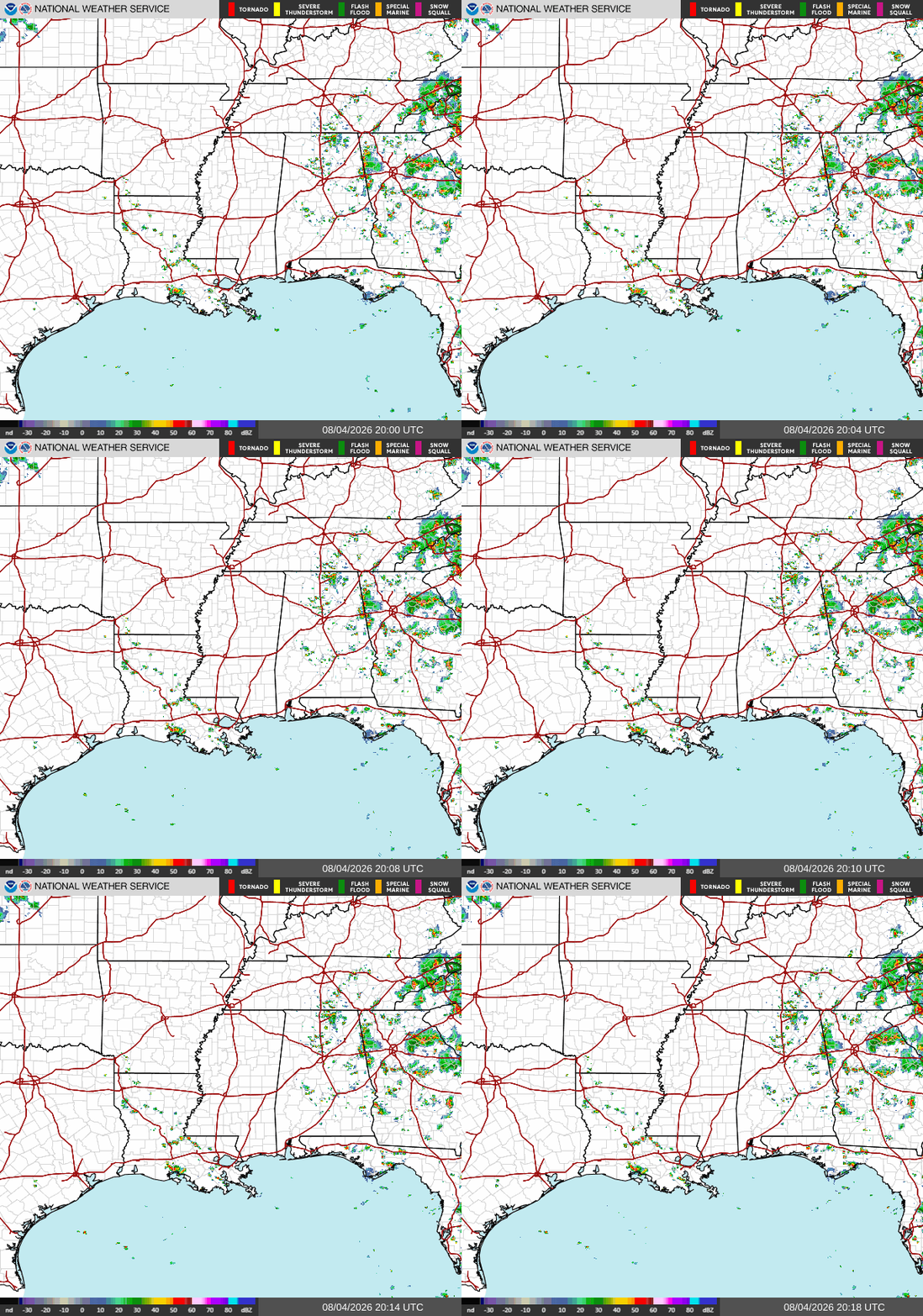
Good afternoon! As of now, we are enjoying our third day in a row of delightfully low humidity. As a result, there are no storms in the main part of our forecast region. Most storms are located in northeastern Alabama and throughout Georgia.
No storms are expected to form in MS, most of LA, and western AL today. A few storms and showers are possible until around 8 tonight in central Louisiana, in the Alexandria area, but they will not have any major impacts.
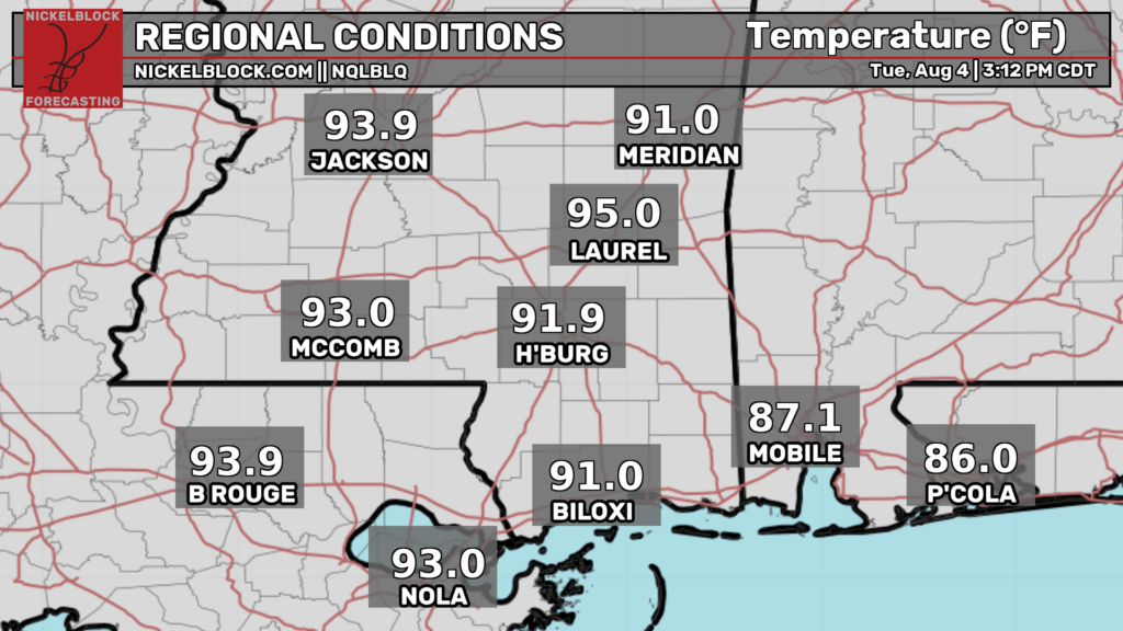
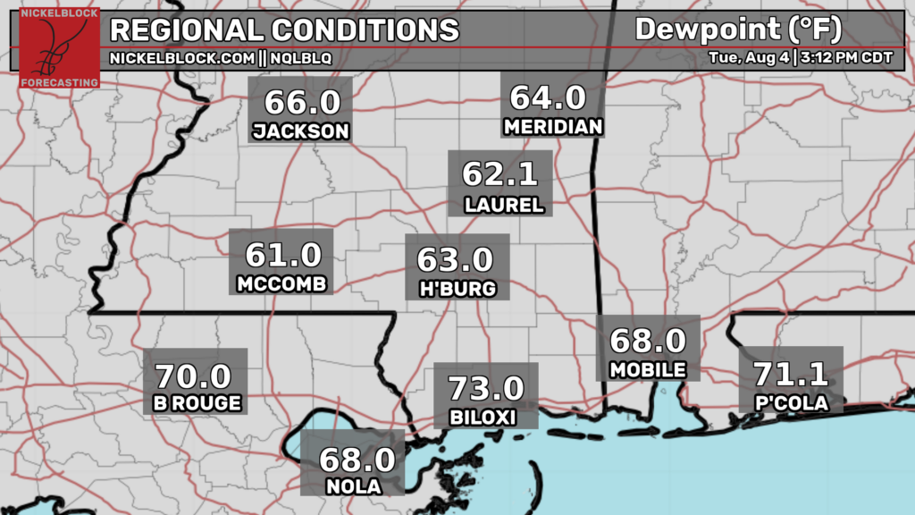
As of 3:20p CDT, temperatures are currently in the lower-mid 90s throughout our area, with southern Mississippi seeing the hottest conditions. However, temperatures are not the full picture.
The current dew points are much lower than average for this time of year. Throughout Mississippi, they are in the low to mid 60s! It’s still hot, but those 90+ temperatures feel a bit more bearable with lower humidity.
Tomorrow
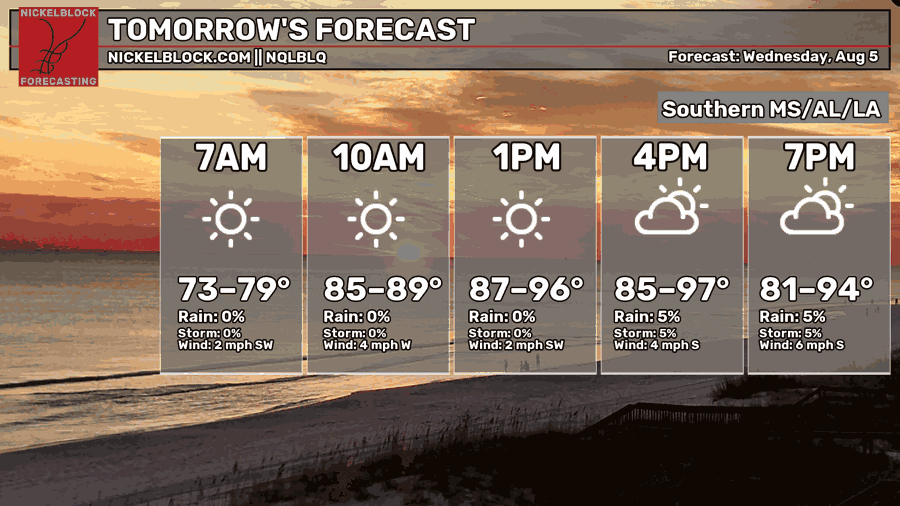
Afternoon high temperatures tomorrow are again going to be hot, potentially reaching the upper 90s for some. Morning lows will bottom out in the mid-upper 70s.
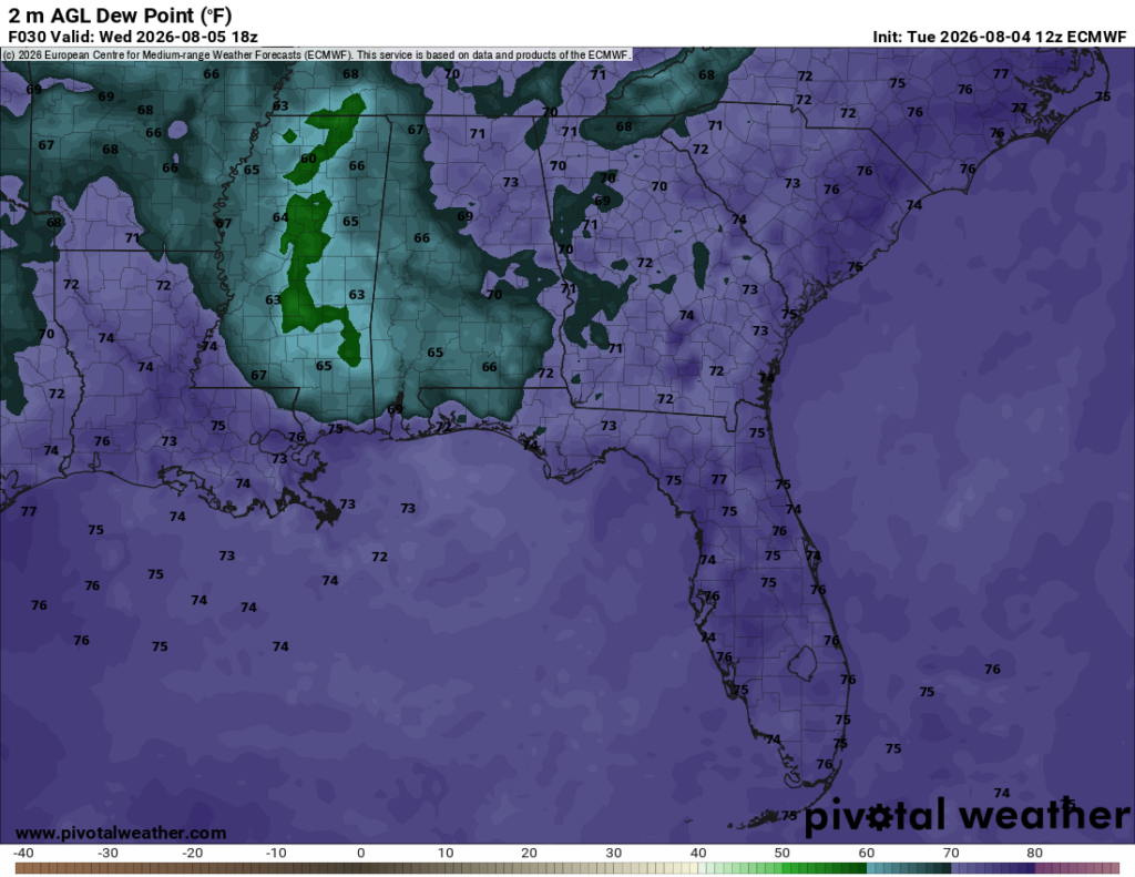
Much like today, the dry air that’s been stuck over our area for the past few days will deliver drier, more comfortable air during the peak of the heat tomorrow. Mississippi is once again the big winner, with afternoon dew point temperatures in the lower 60s and even upper 50s. This will make those highs in the mid 90s not so oppressive.
We have two more days with below average humidity before afternoon dew points in the 70s for our entire region returns on Friday.
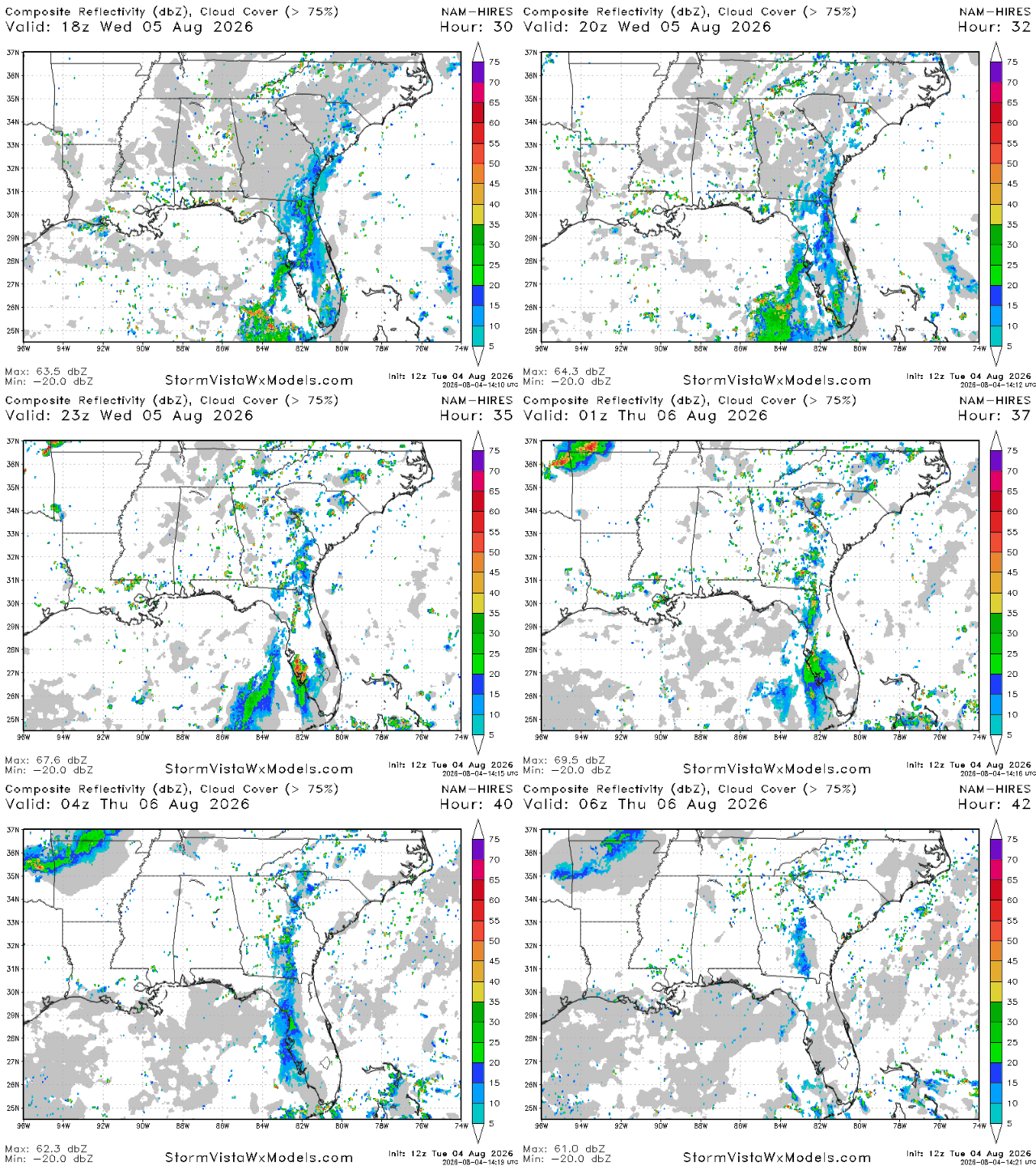
Storms won’t be too big of a deal tomorrow, however some are still possible for some parts of our forecast region such as Louisiana and further east in Georgia. In Louisiana, storms are possible between 4 and 9 pm tomorrow, particularly in the Baton Rouge area. Some scattered storms are also possible throughout Georgia tomorrow afternoon and evening.
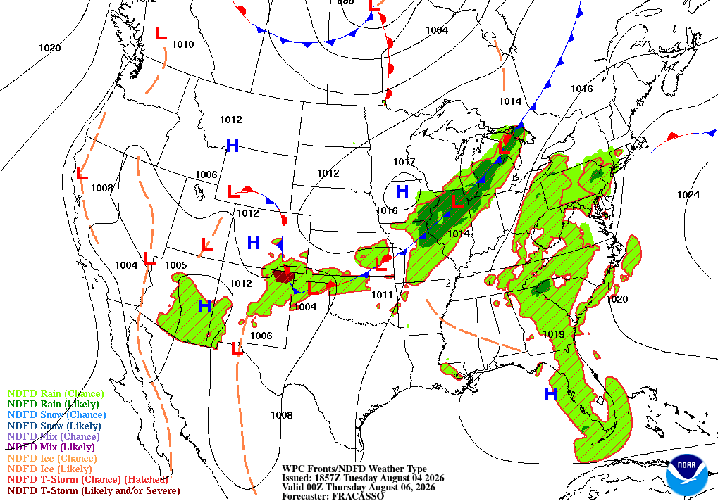
In the coming days, we’re due for another pattern change. The past few days, we’ve dealt with a low pressure center over northern Georgia bringing scattered showers and storms to that area and the surrounding areas. By Thursday, this low pressure will dissipate, leaving our area in between two areas of high pressure, one over the southwest, and one over the subtropical Atlantic.
These two areas of high pressure will force humid gulf air up into our region, putting an end to our comfortable stretch, and bringing daily thunderstorms and summer like heat.
Airport Forecast
KHOU/KIAH (Houston) – Current: temperature is 95ºF, dew point is 72ºF, sky conditions are partly cloudy, winds are coming out of the south at 7 mph, and visibility is 10 miles. Tonight: there is a chance of storms between 5 and 8 tonight, but skies will turn mostly clear after. Minor delays are possible.
KATL (Atlanta) – Current: temperature is 73ºF, dew point is 70ºF, sky conditions are light rain, winds are coming out of the southeast at 3 mph, and visibility is 10 miles. Tonight: thunderstorms are likely until around 5 tonight, then lingering showers may last until after midnight. Minor delays are possible.
KMSY (New Orleans) – Current: temperature is 92ºF, dew point is 70ºF, sky conditions are partly cloudy, winds are calm, and visibility is 10 miles. Tonight: winds will pick up slightly, but no storms are expected. No delays are expected.
KBTR (Baton Rouge) – Current: temperature is 93ºF, dew point is 70ºF, sky conditions are fair, winds are coming out of every which direction at 7 mph, and visibility is 10 miles. Tonight: skies will remain sunny, and no storms are expected. No delays are expected
KSHV (Shreveport) – Current: temperature is 93ºF, dew point is 72ºF, sky conditions are partly cloudy, winds are calm, and visibility is 10 miles. Tonight: skies will remain mostly sunny and no storms are expected. No delays are expected.
KJAN (Jackson) – Current: temperature is 91ºF, dew point is 67ºF, sky conditions are partly cloudy, winds are coming out of every which direction at 3 mph, and visibility is 10 miles. Tonight: skies will turn mostly clear and no storms are expected. No delays are expected.
KBHM (Birmingham) – Current: temperature is 84ºF, dew point is 71ºF, sky conditions are mostly cloudy, winds are coming out of the northwest at 9 mph, and visibility is 10 miles. Tonight: there is a slight chance of storms until around 10-11 pm. Very minor delays are possible.
KMOB (Mobile) – Current: temperature is 90ºF, dew point is 66ºF, sky conditions are mostly clear, winds are coming out of the northwest at 6 mph, and visibility is 10 miles. Tonight: skies will remain mostly clear and no storms are expected. No delays are expected.
KTLH (Tallahassee) – Current: temperature is 91ºF, dew point is 71ºF, sky conditions are mostly cloudy, winds are coming out of the south at 16 mph with gusts up to 21 mph, and visibility is 10 miles. Tonight: there is a chance of storms until around 8 tonight. Minor delays are possible.
Highway Forecast
I-10: A few storms are possible in between Houston and New Orleans as well as southwest of Tallahassee in the FL panhandle, but other than that, little to no storms are forecasted along this highway. Overall, driving conditions will be good tonight.
I-20: Storms currently in northern Georgia will linger until around 8 tonight. Storms are also possible in the Birmingham area between 4 and 8 tonight. No other storms are forecasted anywhere else along this highway. Overall, driving conditions will be good tonight.
I-49: A few pop up storms are possible in the Alexandria/Lafayette area between 4 and 9 tonight. Other than that, storms are unlikely. Overall, driving conditions will be decent tonight.
I-55: A few storms are possible between 4 and 9 only in the Louisiana section of the highway, but they will be weak and should not pose much of an issue. The Mississippi portion of the highway is unlikely to see any storms tonight. Overall, driving conditions will be excellent tonight.
I-59: A few storms are possible from now until around 10 tonight in the northeastern corner of Alabama near the Tennessee border, but no storms are expected anywhere else. Overall, driving conditions will be excellent tonight.
I-65: A few storms are possible from now until around 10-11 tonight in northern Alabama near Huntsville, but no storms are expected to form further south. Overall, driving conditions will be excellent tonight.
I-75: Scattered storms exist all throughout Georgia, particularly in the Atlanta metro area, and will linger until around 9-10 tonight. In Florida, storms will form tonight in the central and southwestern part of the state. Overall, driving conditions may be poor at times. Be aware for water on the road, periods of heavy rain, and gusty winds.
3 Day City Forecast
Tallahassee, FL
Tomorrow: Skies will be sunny throughout the day tomorrow with a high of 91ºF. A few scattered storms are possible beginning in the early afternoon until the late evening. By night, skies will be mostly clear and temperatures should drop into the low 70s.
Thursday: Skies will be mostly sunny throughout the day on Thursday with a high of 91ºF. There is a chance of storms and showers between 2 and 11 pm. By night, skies will be partly cloudy and temperatures should drop into the low-mid 70s.
Friday: Skies will be mostly sunny throughout the day on Friday with a high of 91ºF. Scattered showers and storms are possible between 2 and 8 on Friday. By night, skies will be partly cloudy and temperatures should fall into the low-mid 70s.
Birmingham, AL
Tomorrow: Skies will be mostly sunny throughout the day tomorrow with a high of 89ºF. Foggy conditions are possible in the morning, but the fog will burn off by 9 am. There is also a slight chance of showers and storms tomorrow in the afternoon and evening. By night, skies will be partly cloudy and temperatures should drop into the low 70s.
Thursday: Skies will be sunny throughout the day on Thursday with a high 91ºF. There is a slight chance of storms and showers beginning in the early afternoon lasting until the evening. By night, skies will be mostly clear and temperatures will fall into the low-mid 70s.
Friday: Skies will be mostly sunny throughout the day on Friday with a high of 91ºF. There is a slight chance of showers and storms between the early afternoon and evening. By night, skies will be mostly clear and temperatures should drop into the low-mid 70s.
Mobile, AL
Tomorrow: Skies will be sunny throughout the day tomorrow with a high of 93ºF. A few very weak and minor sea breeze storms are possible tomorrow in the afternoon and evening. By night, skies will be partly cloudy and temperatures should drop into the low-mid 70s.
Thursday: Skies will be sunny throughout the day on Thursday with a high of 92ºF. There is a slight chance of sea breeze storms and showers in the afternoon and evening. By night, skies will be mostly clear and temperatures should drop into the low-mid 70s.
Friday: Skies will be sunny throughout the day on Friday with a high of 92ºF. There is a slight chance of a few sea breeze storms in the afternoon and evening. By night, skies will be mostly clear and temperatures should drop into the low-mid 70s.
Atlanta, GA
Tomorrow: Skies will be mostly sunny throughout the day tomorrow with a high of 86ºF. A few scattered and weak storms are possible tomorrow beginning in the early afternoon and lasting until night. By night, skies will be partly cloudy and temperatures should drop into the low 70s.
Thursday: Skies will be mostly sunny throughout the day on Thursday with a high of 88ºF. There is a chance of scattered showers and storms beginning in the afternoon and lasting until late at night. By night, skies will be partly cloudy and temperatures should drop into the low 70s.
Friday: Skies will be mostly sunny throughout the day on Friday with a high of 88ºF. There is a chance of scattered showers and storms in the afternoon lasting until the late evening. By night, skies will be partly cloudy and temperatures should drop into the low 70s.
Jackson, MS
Tomorrow: Skies will be sunny throughout the day tomorrow with a high of 95ºF. There is a slight chance of a few scattered storms tomorrow in the afternoon and evening. By night, skies will be partly cloudy and temperatures should drop into the low 70s.
Thursday: Skies will be sunny throughout the day on Thursday with a high of 96ºF. Foggy conditions are possible in the morning, but the fog should burn off by 8 am. A few scattered storms may pop up around lunchtime and will linger until the evening. By night, skies will be mostly clear and temperatures should drop into the low-mid 70s.
Friday: Skies will be sunny throughout the day on Friday with a high of 95ºF. Fog is also possible on Friday morning, but the fog should be burnt off by 8 am. No storms are expected on Friday. By night, skies will remain mostly clear and temperatures should drop into the low-mid 70s.
New Orleans, LA
Tomorrow: Skies will be sunny throughout the day tomorrow with a high of 93ºF. A few storms are possible in the morning, then again in the afternoon and evening before 7 pm. By night, skies will mostly clear and temperatures should drop into the mid-upper 70s.
Thursday: Skies will be sunny throughout the day on Thursday with a high of 93ºF. Scattered storms are possible in the area beginning in the early afternoon and lasting until the evening. By night, skies will be mostly clear and temperatures should drop into the mid-upper 70s.
Friday: Skies will be sunny throughout the day on Friday with a high of 93ºF. There is a slight chance of storms and showers beginning in the early afternoon and lasting until the evening. By night, skies will be mostly clear and temperatures should drop into the upper 70s.
Baton Rouge, LA
Tomorrow: Skies will be sunny throughout the day tomorrow with a high of 94ºF. There is a slight chance of scattered showers and storms between 3 and 10 pm tomorrow. By night, skies will be partly cloudy and temperatures should drop into the mid 70s.
Thursday: Skies will be sunny throughout the day on Thursday with a high of 94ºF. There is a chance of storms and showers beginning in the early afternoon and lasting until the evening/night. By night, skies will be mostly clear and temperatures should drop into the mid 70s.
Friday: Skies will be mostly sunny throughout the day on Friday with a high of 94ºF. Storms are not expected at this time for Friday. By night, skies will be mostly clear and temperatures should drop into the mid 70s.
Shreveport, LA
Tomorrow: Skies will be sunny throughout the day tomorrow with a high of 96ºF. A few scattered showers and storms are possible between 1 and 7 pm tomorrow. By night, skies will be mostly clear and temperatures should drop into the mid-upper 70s.
Thursday: Skies will be sunny throughout the day on Thursday with a high of 95ºF. Some storms and showers are possible beginning in the early afternoon and lasting until the evening/night. By night, skies will be mostly clear and temperatures shold drop into the mid 70s.
Friday: Skies will be sunny throughout the day on Friday with a high of 94ºF. No storms are forecasted for Friday at this time. By night, skies will be mostly clear and temperatures should drop into the mid 70s.
Houston, TX
Tomorrow: Skies will be mostly sunny throughout the day tomorrow with a high of 96ºF. A few storms and showers are possible between 4 and 7 tomorrow. By night, skies will be partly cloudy and temperatures should drop into the upper 70s-low 80s.
Thursday: Skies will be mostly sunny throughout the day on Thursday with a high of 95ºF. There is a slight chance of storms and showers beginning in the early afternoon and lasting until the evening. By night, skies will be partly cloudy and temperatures should drop into the upper 70s-low 80s.
Friday: Skies will be mostly sunny throughout the day on Friday with a high of 94ºF. There is a chance of storms and showers beginning in the early afternoon and lasting until the evening. By night, skies will be mostly clear and temperatures should drop into the mid-upper 70s.


