The rain from this morning will continue to move out. But we may not be done with the rain for today. While there will be a lot happening behind the scenes with the weather pattern, at face value, it will feel very typical.
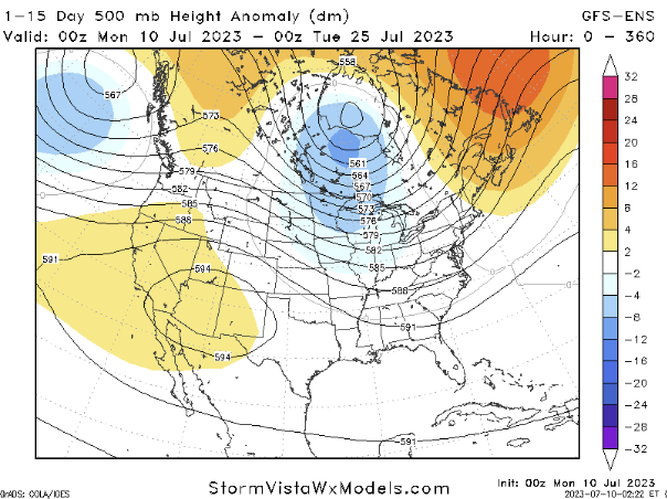
Through Saturday night, the focus of thunderstorm activity will shift southward, with the frontal boundary extending across central portions of the area. As drier air builds in behind the boundary, there is still a possibility of strong to severe storms on Monday and Tuesday.

Moving on to Wednesday, the upper troughing weakens, but the atmospheric moisture levels will increase. As a result, scattered showers and thunderstorms will develop in the afternoon and evening. Thursday will see the strengthening of upper ridging, leading to temperatures climbing into the low to mid-90s.
Regarding the weekend, the latest global models suggest a shift in the upper ridge pattern, indicating a return to northwest flow. This means that chances for showers and storms will persist into the weekend.
So the end result is typical every day storms, with the background vibe of a northwest flow leading to occasional overnight storms.
[wpcode id=”41149″]
REGIONAL DAY TO DAY FORECAST
Today: Showers and thunderstorms likely. Humid with highs in the upper 80s. Northwest winds 5 to 10 mph. Chance of rain 70 percent.
Tonight: Partly cloudy. A slight chance of showers and thunderstorms in the evening, then a chance of showers and thunderstorms after midnight. Lows in the lower 70s. West winds around 5 mph. Chance of rain 50 percent.
Tuesday: Mostly sunny. A chance of showers and thunderstorms in the morning, then showers and thunderstorms likely in the afternoon. Humid with highs around 90. West winds 5 to 10 mph. Chance of rain 60 percent.
Tuesday Night: Mostly cloudy with a few storms possible. Lows in the lower 70s. Chance of rain 20 percent.
Wednesday: Mostly sunny with more storms possible. Highs in the lower 90s. Chance of rain 40 percent. Heat index values up to 105.
Wednesday Night: Mostly cloudy. Lows in the mid 70s.
Thursday: Mostly sunny. A chance of showers and thunderstorms in the afternoon. Highs in the mid 90s. Chance of rain 40 percent. Heat index values up to 110.
Thursday Night: Partly cloudy in the evening, then clearing. Lows in the mid 70s.
Friday: Sunny. A chance of showers and thunderstorms in the afternoon. Highs in the mid 90s. Chance of rain 40 percent. Heat index values up to 110.
Friday Night: Partly cloudy in the evening, then clearing. Lows in the mid 70s.
Saturday: Sunny. A chance of showers and thunderstorms in the afternoon. Highs in the mid 90s. Chance of rain 40 percent. Heat index values up to 110.


