Good morning and happy Saturday, folks!
As the upper-level low to our North begins to leave the region, decreasing the coverage of afternoon showers and thunderstorms, the flooding threat that we experienced earlier this week is finally diminishing. But, with a new pattern arriving in the middle of next week, let’s breakdown the forecast so we’ll have a better handle on what’s to come.
Current Synoptic Picture

Currently over the US, there exists some troughing over the Northwest and locations east of the Rockies, with some slight ridging noted in over the Great Lakes, with an upper-level trough pulling away from the Northeast. Over the Southeast, geopotential heights are around normal, as the upper-level trough moves out of the region and the subtropical high to over the Atlantic tries to build in from the east.
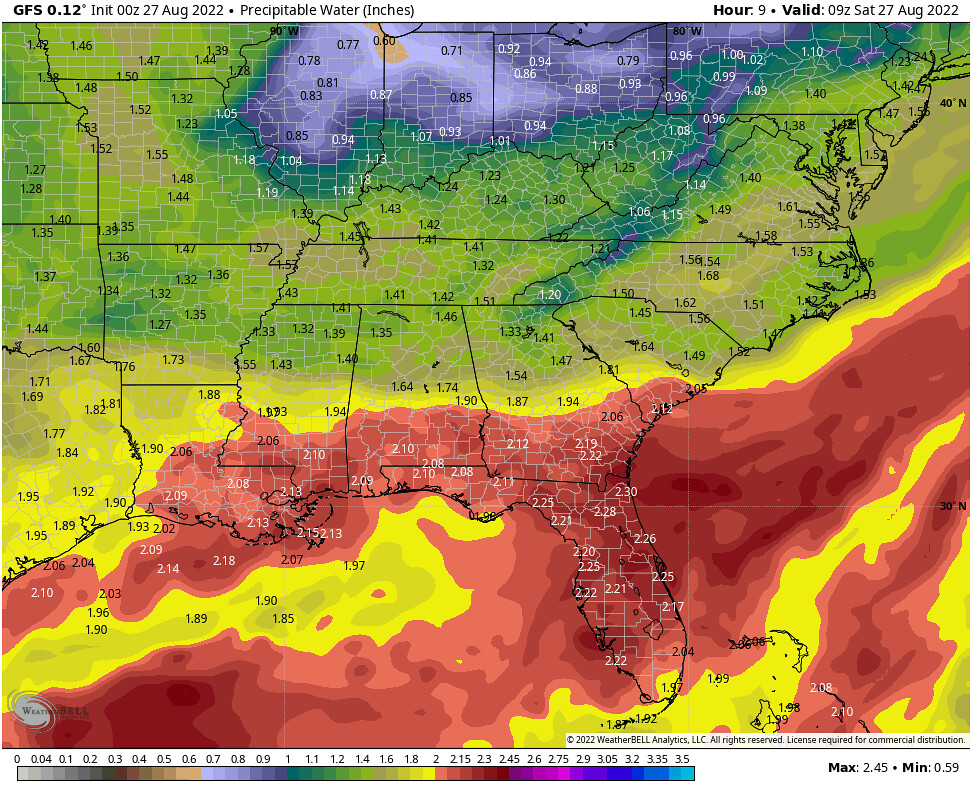
Another thing worth noting is the above-normal precipitable water values across the southern halves of Mississippi and Alabama, with values ranging anywhere from 1.75-2.25″. This moist air mass hasn’t budged much, and has resulted in some flooding rains over the past week.
Today through Monday
Luckily for us, the weekend won’t be a total washout like much of this past week has been. As the upper-level trough is exiting the region and a ridge begins to build instead, the atmosphere will have less forcing for widespread showers and thunderstorms, but rather the typical chance for afternoon thunderstorms.
Temperatures will likely be right around average for this time of year, with highs in the upper 80’s to near 90 and lows in the low 70s.


Tuesday through the End of the Week
By Tuesday, the upper-level trough currently on the West Coast will begin to move into the Great Lakes Region. While the position of the trough will stay to our north, it does force another frontal boundary into the region Tuesday afternoon and into Tuesday evening. This boundary will eventually stall out near the Gulf Coast, which will once again enhance our chances for rain as the boundary weakens through the end of the work week.
The exact placement of where the boundary will stall out isn’t yet set in stone, but locations to the north of the stalled front will likely see some cooler temperatures and lower dewpoints and precipitable water values, which would actually keep these locations on the drier side.


We can see this discrepancy pretty well, as both the American GFS and the European ECMWF models have relatively similar placements of the boundary between the two air masses on Wednesday evening, with much drier dewpoints in the northern third of Mississippi and Alabama. However,…


By Friday morning, the GFS model has the boundary all the way at the Gulf Coast, meanwhile the ECMWF still has significant portions of Mississippi and Alabama in high dewpoints.
As we head into the next weekend, some southerly flow is allowed to kick back up, delivering some more moisture to the region from the Gulf of Mexico, and eventually pushing what’s left of the boundary to the north and out of the region.
Day-to-Day Forecast
Today
Partly to mostly cloudy skies early, followed by a 60-percent chance of an afternoon storm. Expect highs in the mid-80s.
Tomorrow
Partly to mostly cloudy skies early, followed by a 50-percent chance of an afternoon storm. Expect highs in the mid-to-upper 80s.
Monday
Partly cloudy skies early, followed by a 40-percent chance of an afternoon storm. Expect highs in the mid-to-upper 80s.
Tuesday
Partly to mostly cloudy skies early, followed by a 60-percent chance of an afternoon storm. Expect highs in the mid-to-upper 80s.
Wednesday
Partly to mostly cloudy skies early, followed by a 60-percent chance of an afternoon storm. Expect highs in the mid-80s.
Thursday
Partly to mostly cloudy skies early, followed by a 50-percent chance of an afternoon storm. Expect highs in the mid-80s.
Friday
Partly to mostly cloudy skies early, followed by a 50-percent chance of an afternoon storm. Expect highs in the low-to-mid-80s.


