When it’s July it’s hot (or something like that). Of course it’s not hot for the whole region, many people are getting strong to severe thunderstorms.
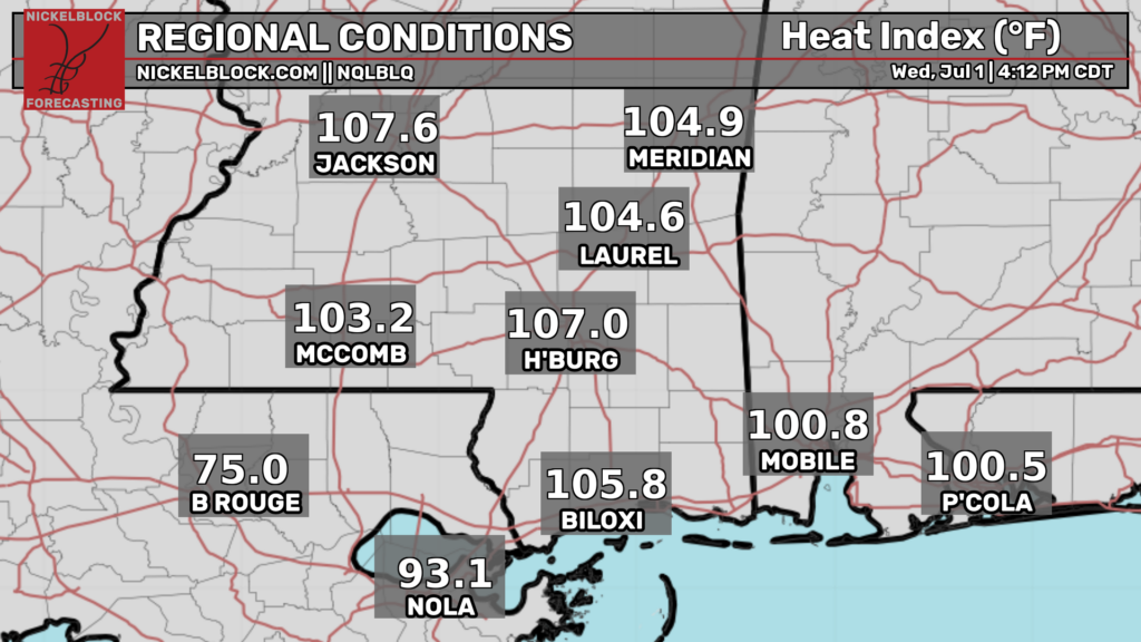
Baton Rouge for example, is much cooler because it is currently pouring there. There are numerous thunderstorm complexes ongoing across the South.
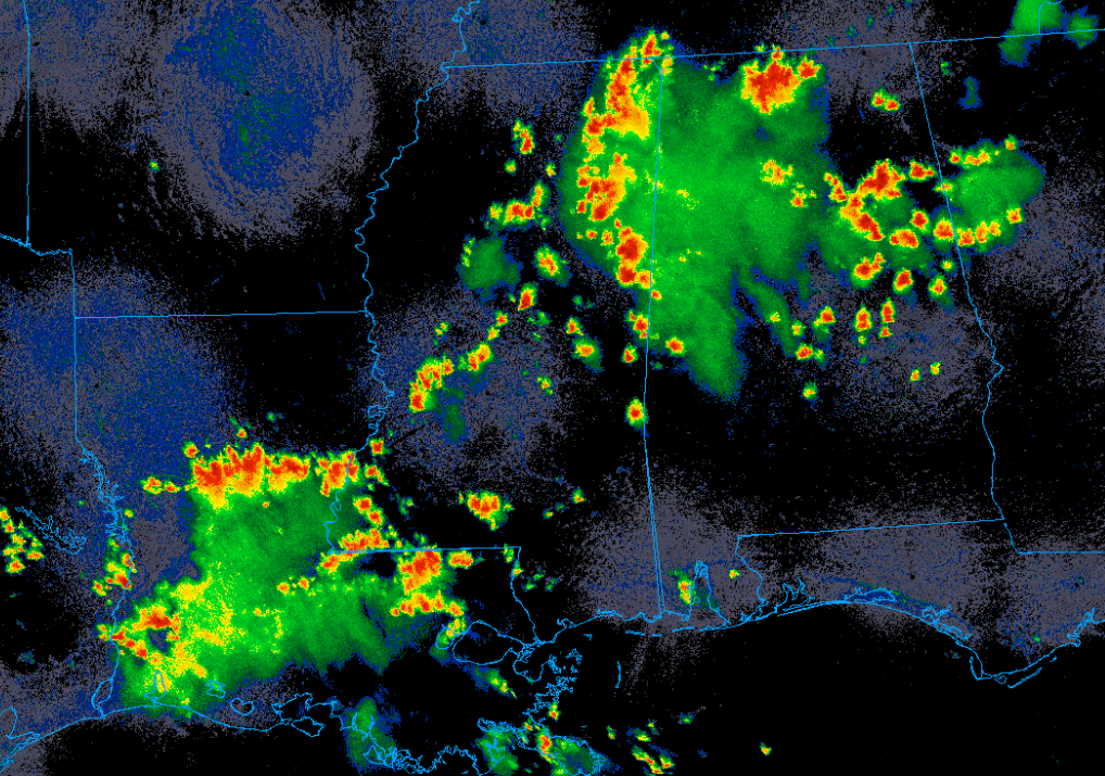
Several severe thunderstorm watches have been issued to cover this threat. The main hazards are heavy rain, frequent lightning, isolated flooding, and damaging straight line winds (up to 60-70 mph). These storms will persist into the late evening before diminishing as the boundary layer stabilizes with the loss of surface heating.
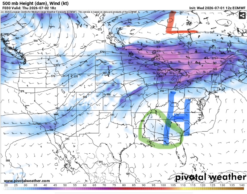
A slight enhancement to the flow around the periphery of the ridge has allowed for a bit more shear than is typical for this time of year. 20-30 knots is not particularly impressive compared to what we get in the cool season, but it is enough to support forward propagating clusters of storms that may produce severe caliber wind gusts. The strange result of this setup is that storms will be moving west. Make sure to keep an eye to the east of your area as these storms persist.
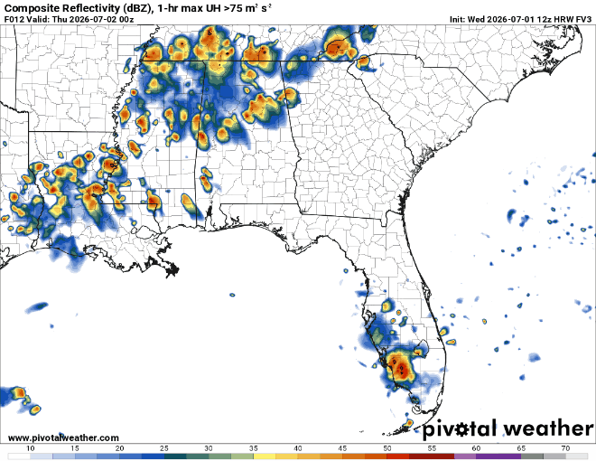
Tomorrow will be similar to today with very hot conditions and westward moving storms. Convective coverage may be a bit less than today along the Gulf. Indeed, the Storm Prediction Center has outlined northern Georgia into the southern Appalachians as the area with the greatest severe weather threat (level 2/5, slight risk).
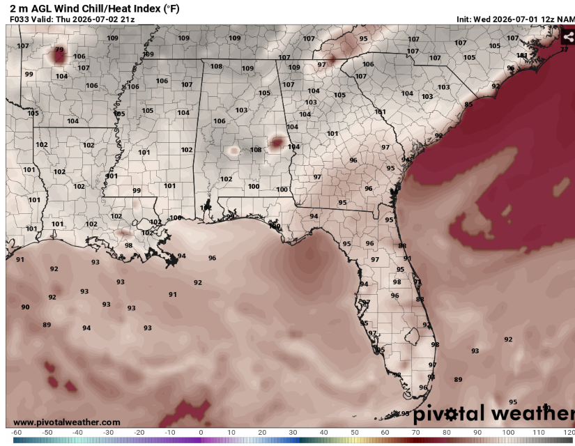
For areas that stay dry, it will be another very hot day. Temperatures in the 90s with high humidity will lead to potentially dangerous heat. Make sure to drink plenty of water and take breaks in the AC if you must be outside.
The enhanced flow around the ridge will likely slid away from out region after this but the story will remain the same for the foreseeable future. Very hot and humid with scattered thunderstorms.
Airport Forecasts
Houston (KIAH/KHOU)- A few storms possible this evening. Tomorrow morning will be calm but afternoon thunderstorms are possible which may lead to a some lightning or downburst delays.
Shreveport (KSHV)- A storm or two possible this evening. Most of tomorrow should be fine but we can’t rule an isolated afternoon storm and therefore a brief delay for lightning or downdrafts.
Baton Rouge (KBTR)- Storms in the area are gradually clearing. Flights tomorrow morning will be fine. There will probably be a few storms in the area during the afternoon. These may cause some quick delays for lightning or microbursts.
New Orleans (KMSY)- Storms will slowly clear up this evening. Scattered mid day thunderstorms are possible posing a risk for lightning and downbursts related delays.
Jackson (KJAN)- Storms in the area should gradually diminish. Tomorrow should be mainly dry but can’t rule out a quick delay for lightning or downdrafts if a storm does develop.
Mobile (KMOB)- Looks good. There is always a chance of a rogue thunderstorm but as of now it looks dry and calm.
Birmingham (KBMH)-Storms in the area die off around sunset. Tomorrow morning will be fine. Thunderstorm chances increase during the late afternoon into the evening. There is a chance for some delays due to microbursts or lightning.
Tallahassee (KTLH)- Should be fine. Just looks hot and clear.
Atlanta (KATL)- The next 18 hours should be calm. Thunderstorm chances ramp up tomorrow afternoon. Delays will be possible for lightning and microbursts
Highways
I-10 – Storms will hang around for a few more hours over Louisiana before dying out. These may cause some fairly significant ponding on the road so make sure to slow down. There will likely be at least some storms along the route tomorrow afternoon. This is most likely again over Louisiana but should be less widespread than today.
I-20 – Lots of storms across Mississippi and Alabama right now. These will persist a few more hours before loosing steam. The morning hours should be dry before scattered storms develop again, this time from far eastern Mississippi towards central Georgia.
I-49 – Storms currently over Louisiana will last a few more hours before dying off. Tomorrow should be mostly dry but can’t rule out an isolated storm over southwest Louisiana during the afternoon.
I-55 and I-59 – It’s a mess out there right now and will likely take a few hours for the storms over northern Mississippi to clear. Tomorrow will be dryer but there is still a good chance of storms over the same areas tomorrow afternoon into the evening.
I-65 – Similar story. Storms will take a while to fully clear across northern Alabama. Tomorrow will likely feature scattered storms across the same hours from the dinner hour into the late evening.
I-75 – Most areas will be dry south of Atlanta or so. Northern Georgia and north will likely receive multiple rounds of potentially severe storms which may slow down travel significantly.
City Forecasts
Houston, TX
Tonight- Any storms clear out by mid evening. Partly cloudy with a low in the upper 70s.
Tomorrow- Mostly sunny with a high in the mid 90s. Scattered afternoon thunderstorms possible.
Friday- Mostly sunny with a high in the mid 90s. Isolated afternoon thunderstorms possible.
Shreveport, LA
Tonight- A storm or two possible early. Partly cloudy with a low in the upper 70s.
Tomorrow- Mostly sunny with a high in the mid 90s. An isolated afternoon storm is possible.
Friday- Sunny and dry with a high in the mid 90s.
Baton Rouge, LA
Tonight- Decreasing clouds as storms clear. Low in the mid 70s.
Tomorrow- Increasing clouds with a high in the low 90s. Scattered afternoon thunderstorms likely.
Friday- Mostly sunny with a high in the mid 90s. Isolated afternoon thunderstorms possible.
New Orleans, LA
Tonight- Storms clear early. Partly cloudy with a low around 80.
Tomorrow- Scattered mid day storms possible. Mostly sunny with a high in the low 90s.
Friday- Mostly sunny with a high in the low 90s. Isolated afternoon thunderstorms possible.
Jackson, MS
Tonight- Storms clear out early. Partly cloudy with a low in the mid 70s.
Tomorrow- Mostly sunny with a high in the mid 90s. Most likely dry but there may be an isolated storm during the afternoon.
Friday- Sunny with a high in the mid 90s. Dry.
Birmingham, AL
Tonight- Decreasing clouds with a low in the upper 70s.
Tomorrow- Mostly sunny with a high in the mid 90s. Scattered afternoon thunderstorms likely.
Friday- Mostly sunny with a high in the mid 90s. Scattered afternoon thunderstorms possible.
Mobile, AL
Tonight- Mostly clear with a low in the mid 70s. Dry.
Tomorrow- Sunny with a high in the mid 90s. No rain.
Friday- Another hot sunny day with a high in the mid 90s.
Tallahassee, FL
Tonight- Clear and dry with a low in the low 70s.
Tomorrow- Sunny with a high in the mid 90s. No precipitation expected.
Friday- Sunny and dry with a high in the mid 90s.
Atlanta, GA
Tonight- Partly cloudy with a low in the mid 70s. Dry.
Tomorrow- Mostly sunny with a high in the upper 90s. Scattered afternoon thunderstorms likely.
Friday- Mostly sunny with a high in the upper 90s. Isolated afternoon thunderstorms possible.


