On the heels of my Part 1 of the Winter 2021-2022 Winter Outlook where I posted about the La Nina Watch that was in effect, today NOAA’s Climate Prediction Center has up’d the anti and it is now a La Nina Advisory.

That means that La Nina is now expected to develop (it has already, in this case, according to the CPC) and continue through the rest of the next season (Winter).
“Our scientists have been tracking the potential development of a La Nina since this summer, and it was a factor in the above-normal hurricane season forecast, which we have seen unfold,” Mike Halpert, deputy director of NOAA’s Climate Prediction Center, said in a press release. “La Nina also influences weather across the country during the winter, and it will influence our upcoming temperature and precipitation outlooks.”
The CPC noted that there is now an 87-percent chance that La Nina develops.
This will be the second-consecutive La Nina Winter. And that isn’t somethign that is cmmon, but it also isn’t uncommon.
There was a cool post by Nat Johnson over at climate.gov about this. In part, Nat wrote:
If all essential processes that comprise this feedback process were equal but opposite for El Niño and La Niña, then we might expect mirror opposite patterns. However, this isn’t the case. For example, the response of the trade winds to the Niño3.4 surface temperatures is unequal between warmer and cooler surface conditions. We see this in the scatter plot of monthly May–September zonal (east-west direction) wind stress anomalies in the equatorial Pacific versus the Niño3.4 surface temperature anomalies. As we expect, warmer Niño3.4 surface temperatures that are tied to El Niño conditions bring weaker trade winds and a weaker Walker circulation (positive wind stress anomalies), whereas cooler Niño3.4 conditions bring stronger trade winds (negative wind stress anomalies) connected with a stronger Walker circulation.
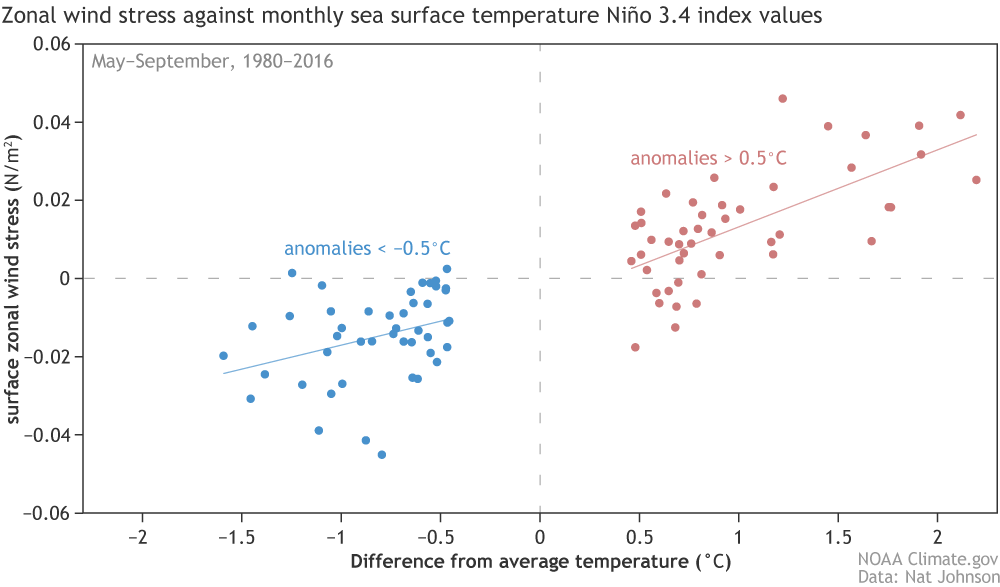
However, the plot also reveals that the relationship between the warm (El Niño) and cool (La Niña) sea surface temperature anomalies and the wind anomalies they generate is not equal. El Niño’s warm water anomalies generally produce wind stress anomalies that are stronger and farther east than those produced by cool La Niña anomalies of equal strength. The stronger response is demonstrated by the steeper slope of the red line versus the blue line. This difference may seem a bit subtle, but it can have big consequences for ENSO asymmetry.
As we head into this Winter, La Nina will likely become a major player in our regional weather and overall weather patterns.


