Hello everyone; I hope your day is going well. Before starting this forecast, I wanted to let everyone know that I am on vacation in Hawaii, so this forecast may not be as detailed as normal, but I will do my best.
Looking at our local region, the two primary things to discuss are the hot temperatures and the chance for afternoon thunderstorms. Tomorrow, the Gulf Coast could see temperatures approaching the low-90s, with heat indexes much warmer than that. Also, we are looking at the chance of seeing some scattered afternoon thunderstorms, as one would expect this time of year. Looking at next week, even hotter temperatures are expected.
[wpcode id=”41149″]
Tomorrow’s Temperature forecast
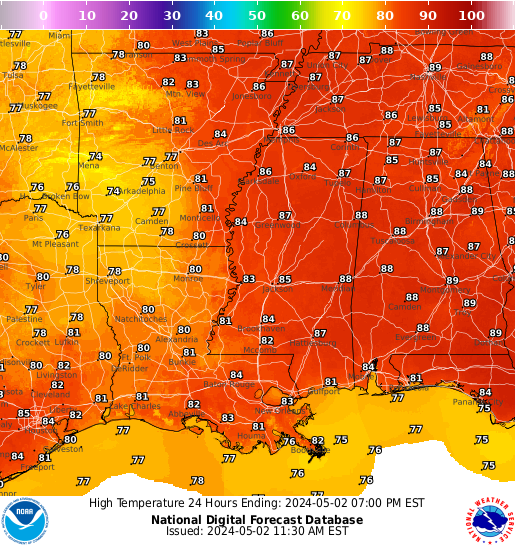

Tomorrow’s temperatures should bring more of what we have seen over the last few days, with hot and humid conditions expected. Areas along the coast should expect the highest temperatures, with readings approaching the low 90s. Heat index values are expected to reach over 100 Fahrenheit (38 Celsius). Even though this may be hot to some, remember that the average high is about 90 degrees Fahrenheit (32 Celsius). Although these are average temperatures, those in this area should be taking heat-related precautions and remember never to leave anyone in a car outside.
Unfortunately, overnight temperatures will not allow for much relief, with overnight lows only in the high 70s. The only relief from these scalding temperatures will be the scattered showers and thunderstorms, which I will get into.

Looking at the rainfall chances for tomorrow, the highest chance of seeing precipitation will be in southern Louisiana and Mississippi. As one would expect in this region, afternoon convective thunderstorms are always a possibility, so these rain chances should come as no surprise to residents of the area. Baton Rouge, New Orleans, and Gulfport have the highest chance of seeing rain or a thunderstorm. Remember that lightning is very dangerous and if you hear thunder, you are close enough to be struck by lightning.

[wpcode id=”41149″]
Extended Outlook

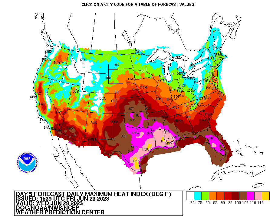
Looking at the extended outlook for the region, there is one thing that is catching my eye, which is how far north the sub-tropical jet is expected to move. Looking at the chart above, the red and orange colors show where stronger winds are, which represents the jet stream. Seeing how far north the subtropical jet is moving, there is one thing that this will bring.
That is hot, humid air from the tropics.
Expect temperatures to rise by the end of the weekend and stay high through this next week. Air temperatures could top hit 100 degrees Fahrenheit (38 degrees Celsius). That does not include the heat index values, which are expected to hit 120 degrees Fahrenheit (49 degrees Celsius) in some areas. These temperatures can induce heat-related illness in as little as 30 minutes, so please take proper heat-related precautions.
[wpcode id=”41149″]
Regional Day-to-Day Forecast.
Today: Scattered showers and thunderstorms. Highs in the low 90s and a 60% chance of rainfall. Winds from the south at 5-10 mph
Tonight: Mostly cloudy with lows in the high 70s. Winds from the southwest at 5-10mph
Tomorrow: Mostly sunny with highs in the mid-90s and heat index values in the mid-100s. There is a 20% chance of rain. Winds from the southwest at 5-10mph
Tomorrow Night: Mostly clear with lows in the high 70s. There is a 0% chance of rainfall. Winds from the southwest at 10mph
Monday: Mostly sunny with highs in the mid-90s and a heat index around 110. Winds will be light and variable.
Monday Night: Mostly clear with lows around 80. Winds from the southwest at 10-15 mph.
Tuesday: Sunny with a 20% chance of rainfall. Highs in the mid-90s with a heat index of around 110. Winds from the west at around 10 mph.
Tuesday Night: Mostly clear with lows around 80. Winds from the southwest at 10-15 mph.
Wednesday: Mostly sunny with highs in the mid-90s and a heat index around 110. Winds will be light and variable.
Wednesday Night: Mostly clear with lows around 80. Winds from the southwest at 10-15 mph


