This weekend, we are seeing rain all across the Eastern US as well the Pacific Northwest as several cold fronts sweeping across US. As our upper level ridge over Texas persists, much of the South Central US will be under extreme heat for the foreseeable future until this pattern breaks. But until then, temperatures into the 90s and and 100 in parts of Texas will continue during this unseasonably hot Summer for the region.
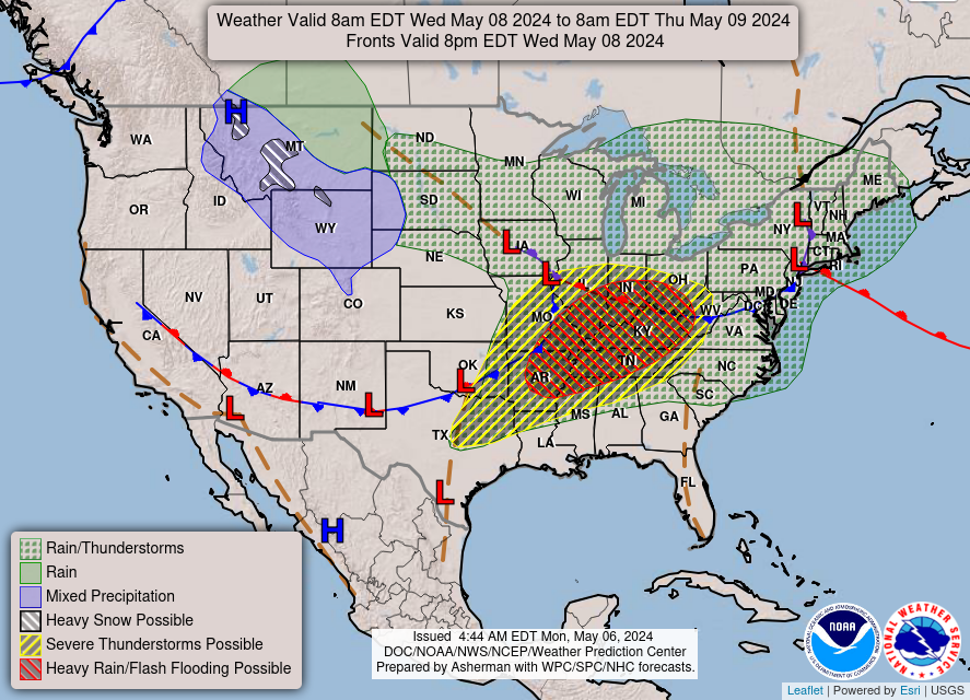
Severe weather across the US is calming down Sunday as the only main area of concern for servere thunderstorms will be Southwestern Ohio, Kentucky, and Central and Eastern Tennessee. The rest of the Eastern US will only be seeing rain and light thunderstorms that will persist into next week for the New England area.
[wpcode id=”41149″]
Rainy Week Ahead for the Eastern US
With one low pressure system over Pennsylvania by Sunday moving out towards the coast, another system will be moving in behind it for more rain for the start of the week. Heading into Monday, much of the rain that was sweeping over the Midwest this past weekend will continue to move east towards the coast. This will bring a possible threat of thunderstorms throughout the East Coast with the Storm Prediction Center issuing a 15% chance of severe weather along the active region show extending from North Carolina to Maryland.
This extended amount of rain will be of possible concern for the New England area as this low pressure system will possibly linger over this region for the rest of the week. Central New York is looking to face the brunt of this system in terms of rain totals.
[wpcode id=”41149″]
An Unseasonably Hot Summer for the South Central
High temperatures into the 90s and 100s will continue into the weekend across regions of Texas, Louisiana, and Southern Mississippi. As the upper-level ridge over Texas persists, hot air over the continental area traps in the hot air will continue to bring dangerous conditions for anyone that plans to stay outside for an extended amount of time. Over the past couple weeks, the heat index over the South Central has consistently been above average for the season. Central Texas will continue to experience the worst of this heat while along the rest of the Gulf Coast, temperatures will reach well into the mid 90s. With humid air along the coast seeping inland, the heat index in many areas could exceed past 110 degrees so be careful in these areas of risk.


[wpcode id=”41149″]
Extended Outlook
The upper-level ridge over Texas is currently looking to possibly breakdown by the next weekend which could bring some much needed relief of cool air to the region and finally end the heat wave. But in the time being, most of the United States will be expecting much of the same weather from last week with rain across the Midwest and Eastern US.
Conclusion
With much of the same weather patterns dominating the US at the start of this season, the weekend is looking to be very rainy and wet with some slight chance of thunderstorms. Excessively hot air will continue to be trapped around Central Texas to deliver warm temperatures all across the South Central region extending along the coast.


