Looking ahead to the 4/4/19 severe weather potential for south Mississippi
Author: Nick Lilja
|| Published: 4/2/2019 at 11:34pm
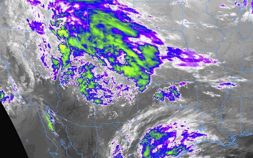
Infrared Satellite Data // Courtesy: College of DuPage Meteorology
Thankfully, there isn’t much to write home about with this round of potential severe weather. As a system slides by to the north, it will pull a warm front north during the day before pushing an MCS through the area in the evening.
This isn’t the a-typical Low-Pressure-With-A-Cold-Front-Swings-Through-And-Makes-It-Storm kind of setup. It is more wishy-washy and unpredictable. Really more of a May severe weather type of setup. Of note: unpredictable doesn’t necessarily mean, more volatile. It just means it is tough to pinpoint specifics.
4/4/19 700mb Vertical Velocity at 3pm from 4/3/19 00z GFS data // Courtesy: Pivotal Weather
And I know how much everyone values specifics, so I don’t want to over-promise something that I can’t deliver on.
But, everyone knows the routine. Because it is South Mississippi, that means the area isn’t ever completely “out of the woods” with respect to severe weather. Even if it isn’t an a-typical setup. If it storms, wind and hail are possible. The potential for some localized flooding is too. And, oh yeah, the chance for a tornadoes.
Blah. Blah. Blah. Am I right?
Even though this isn’t the a-typical setup, and even though the overall threat for severe weather seems limited, it is important o keep tabs on the weather on Thursday. Because if the chips fall in juuuust the right way, significant severe weather could develop. But, I’ll touch on that a bit later…
Timeline
The latest data (as of this writing) suggests the first raindrops will fall as early as 8am on Thursday. The same data also shows the first storms developing around 10am. The first batch of storms may linger through 1pm.
There looks to be a short break (depending on your specific location) between about 1pm and 4pm before more storms redevelop and move through again.
The second wave of storms will push through between 4pm and 9pm.
Threats
In general, the main concern is for gusty wind and hail up to the size of golfballs with storms on Thursday.
4/4/19 Forecast sounding for 7pm showing from 4/3/19 00z NAM3km data showing skinny CAPE, decent shear, and copious helicity
But the specific threats are going to be determined by what time of day the storms are affecting you. And the threats will also vary by location. The specifics, though, aren;t going to be terribly accurate at this point.
To borrow a line from Andre 3000, “I’m just being honest.”
I have data and maps I could show you that pinpoint where the rain will be at specific times, but I don’t believe them. There are limits to what these models can do accurately spatially and temporally. At this distance in time, beyond 36 hours, usually one is going to fail. That means, it might get the timing of the rain right, but it gets the placement wrong. Or it’ll get the placement spot on, but be of by a few hours (or more).
As for the tornado threat, and the significant severe weather threat, I think that will take a combination of factors that are currently unforecastable.
So, what would be need, you ask? Well, as the MCS pushes east through the area, if – BIG IF – storms linger along the southern and southwestern edge where a stationary boundary sets up, there may be sufficient turning of the wind with height in the mid and upper levels as well as the warm air and low LCL heights in the lower levels to promote the development of a tornado. But it is highly dependant on those things… PLUS! It is also dependent on the forward speed and trajectory of the storm versus the general flow in the atmosphere.
The specifics of all of those things are unknowable at this time. However because that scenario isn’t that farfetched, it is included in our threats.
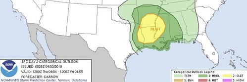
From the SPC
…SUMMARY…
Severe threat is expected to focus across the lower Mississippi Valley Thursday.
…Lower MS Valley…
Progressive short-wave trough is forecast to eject across the southern Rockies into OK/north TX by 04/12z. This feature should dislodge a lee trough off the southern High Plains to a position from southwestern AR into central TX by late afternoon. Early in the period, exit region of mid-level speed max is expected to focus ascent across eastern OK/AR. Aided by low-level warm advection, clusters of elevated convection are expected to spread east along nose of southwesterly LLJ. Hail may accompany the strongest elevated convection as steep mid-level lapse rates should advect into this region ahead of the short wave. During the day, higher boundary-layer moisture should advance into the ArkLaTex region which should enhance the prospect for potential surface-based thunderstorms near the aforementioned boundary draped across this region.
SPC Day 2 Outlook
However, short-wave trough quickly shifts east of this region and timing is not particularly favorable for late afternoon support along the southwest-northeast oriented boundary. For these reasons it appears low-level warm advection may be the primary forcing mechanism for potential strong/severe thunderstorm development through the period. Strong wind fields suggest rotating storms are possible and isolated supercells may be noted within a broader convective precip shield.
By the time the 12z models start to complete (around noon) on Wednesday we will start to get a better idea about specifics. But even then, it won’t be perfect.
Author of the article:
Nick Lilja
Nick is former television meteorologist with stints in Amarillo and Hattiesburg. During his time in Hattiesburg, he was also an adjunct professor at the University of Southern Mississippi. He is a graduate of both Oregon State and Syracuse University that now calls Houston home. Now that he is retired from TV, he runs this site and its app in his spare time.