Quieter weather is expected for the majority of the CONUS as a low pressure system brings in drier air behind its associated cold front beginning late Sunday into the beginning of this week. The Plains, Midwest, and Great Lakes will see these pleasant conditions first followed by the Mid Atlantic and Northeast as the front pushes eastward. The Southeast and near the Gulf however, will remain stormy the next several days as the front stalls and creates a boundary over those regions.
Transitioning Subtropical Ridge
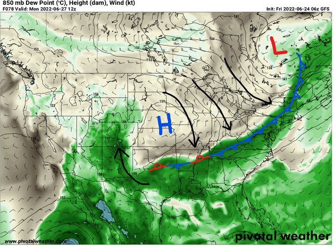
Our 500mb high pressure/ridge will have room to move westward toward the Pacific Coast as the Upper Plains low pressure system moves eastward. The transition is already evident when looking at the 500mb pressure map as a new ridge axis is developing to the west (as denoted by the orange line in the above image); however, this will only last a few days, as the upper-level ridging will return to the southern and central U.S. by Wednesday, albeit a less pronounced ridge than we have been previously experiencing.

Continental Cold Front
As the Great Plains low pressure system moves eastward, a cold front will sweep across the Midwest and Great Lakes by Monday and the East Coast by Tuesday. Drier air will arrive behind the front along with a surface high pressure, bringing with it sunny skies as the sinking air hinders most cloud development and precipitation chances. This calmer weather will also arrive at the East Coast; however, the front will stall across the South and Southeast causing summer-time thunderstorm development to be more widespread for the next several days.
The image below is an estimate of how much rainfall (in inches) is expected between late Monday into late Wednesday. A large portion of the U.S. is expected to stay dry after the front has pushed through and the majority of the rainfall will be focused across the Southeast and along the Gulf where the front is expected to stall.

Monsoon Flooding Threat
Monsoonal rainfall continues today across parts of Arizona, New Mexico, and southwestern portions of the Great Plains as there are marginal and slight risks of excessive rainfall. The image below was issued Friday for today and is valid through Sunday morning, depicting the risk for flash flooding associated with the developing showers and thunderstorms. If you see water covering the road, turn around, don’t drown! By next week a ridge will have moved over the Southwest, inhibiting the moonsoon moisture at least until the end of next week as the ridge shifts east again.