The Storm Prediction Center held onto – and even expanded – the threat for severe weather across parts of South Mississippi for tonight and into early tomorrow morning. Plus, model guidance is showing that the storms anticipated to move through have sped up a bit, too.
Quick hitter
The SPC actually extended the risk for severe weather southeast. This is a bit surprising given the atmospheric setup this far from the area of mid-level low pressure.
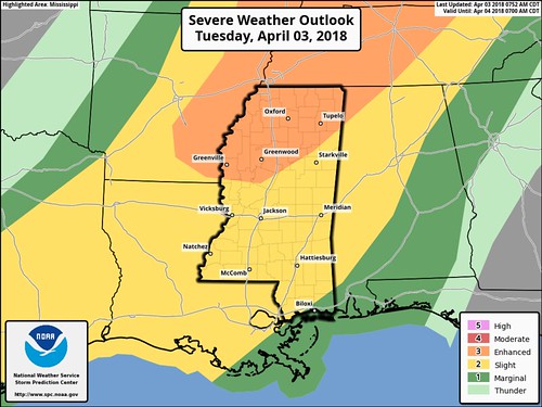
Short of a low-level or surface low developing and riding up the front, it may be difficult for storms to hold onto their strength as we move through the evening. It is something we will monitor closely as the threat for heavy rain, frequent lightning, gusty wind, small hail and even a tornado or two cannot be ruled out.
Timeline sped up
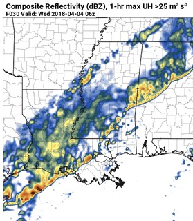
Looking at the model guidance for tonight, most have the line of storms showing up on the doorstep to South Mississippi between 7pm and 9pm (as opposed to 9pm to 11pm, like last night’s data was showing).
There is a chance this timeline could speed up even further. Keep an eye to the sky and your favorite weather app handy.
Still not sold
For the science enthusiasts out there, here is why I’m not sold – yet. Model guidance shows shortened, criss-crossing hodographs, lightrer low-leve wind speeds, low-level shear is thus quite limited, and thus the updraft helicity numbers aren’t very high.
For south Mississippi, that usually holds out severe chances in check. Doesn’t mean there will be no severe weahter, but rather, that it will be a here-and-there type of thing, not an everywhere type of thing.
I’m still cautiously optimistic we luck out like with previous severe weather threats where everyone – but South Mississippi – gets severe storms. That said, “hope for the best, prepare for the worst” applies. While we can all hope it passes us by, we’d better all be prepared for the threat for severe storms.
More details to come as we head through this morning and into the afternoon!


