Temps this morning are hovering around the freezing mark. If you’re headed out, make sure to grab the jacket – you’ll want it. As we move through the next few days, we will have a few shots for rain. Systems will be pushing through the area every few days and will keep the area generally damp.
THE NEXT 7 DAYS
The first shot for rain arrives Friday night and into Saturday morning. The map below, on the left, is from the Euro and shows the area of low pressure skirting by to our south. This will limit the risk for severe weather. The CIPS Analogs map is below the surface map and only highlights a few areas where severe weather is historically possible in this kind of setup.
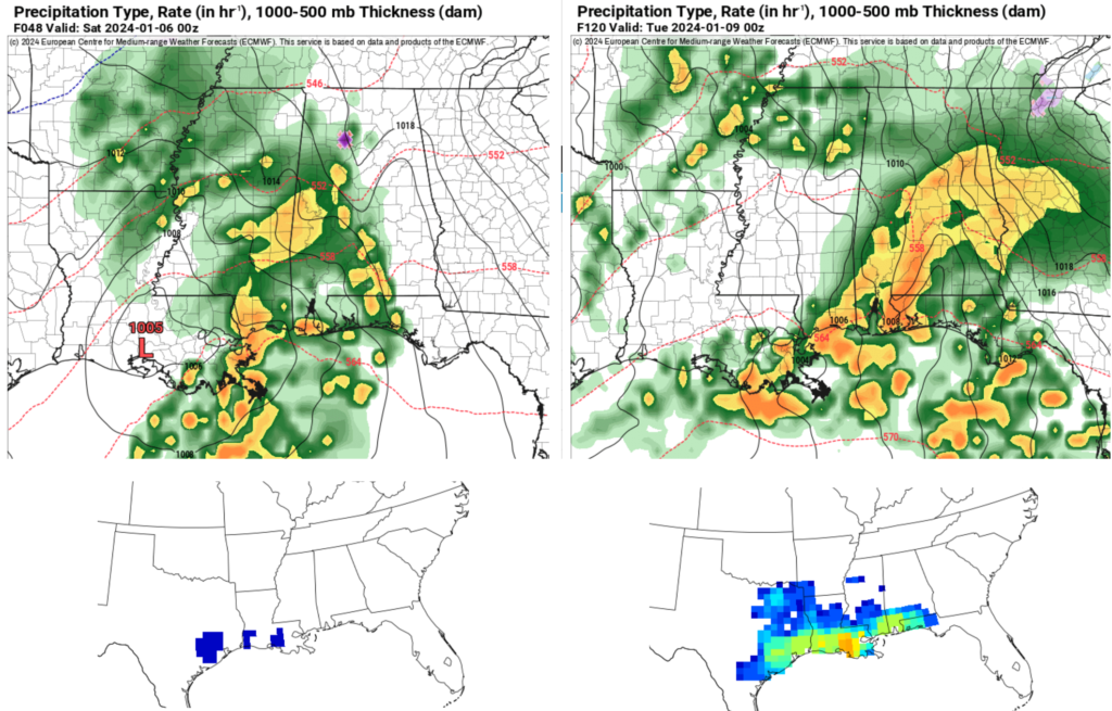
After that, above and on the right, is the next system that arrives Monday and into Tuesday. This one may have more of a bite – but there is still a fair bit of uncertainty about the specifics. The surface map shows a wide area of shower and thunderstorm activity ahead of a cold front slated to move through on Tuesday morning. But it looks like most of this is behind a warm front that is rather diffuse.
Model guidance shows dewpoints only rebounding into the upper 50s and low 60s. And, historically speaking, that is barely enough moisture for severe weather down here. Speaking of history, the CIPS Analogs show a reasonable shot for a few severe storms, but most of the risk is back into Texas and southern Louisiana and hugging the coastline.
The SPC has introduced a Slight Risk for the area on Monday and into Tuesday morning. That is a “2” on the 1-to-5 scale where a “5” is the highest risk for the most significant severe weather.
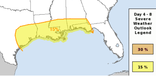
But given the current data, I think the Slight Risk is moved way too far northward in our area. It is worth monitoring, for certain, but given the data yesterday and today, we may be just barely too cool and too dry.
Once we get through that system, another one moves through Thursday and into Friday.
LATE JANUARY COLD SNAP CHATTER
Boy, oh boy! There is a lot of buzz on the ole interwebz about the Polar Vortex. It has even grabbed the attention of news outlets!

But before you dig out the snow gear and the big jackets from the attic, know that there are still a ton of unknowns with the potential for cold in late January. The big one is that we don’t know where it will be coldest yet. And we won’t know for another few weeks.
The buzz all started when someone pulled this map from an online data source and posted on social media. The map, as you can tell, shows some very, very cold temperatures for the Lower 48.
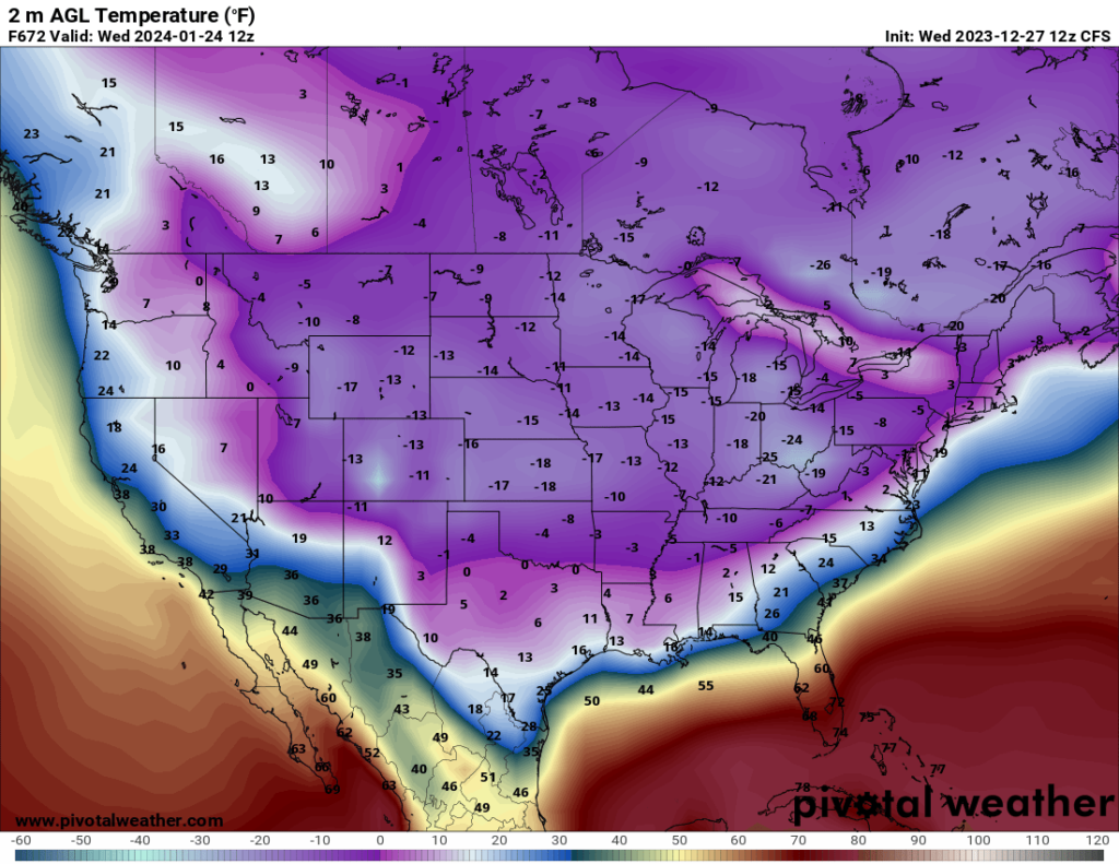
The biggest problem is: It isn’t accurate.
The point of the CFS model isn’t to produce a spot temperature forecast a month out. According to NOAA, the CFS, Climate Forecast System,” models the interactions between Earth’s oceans, land, and atmosphere on a global scale. The model is produced by several dozen scientists under guidance from the National Centers for Environmental Prediction (NCEP), and generates hourly data with a ½° horizontal resolution (approximately 56 km).”
It looks at big picture stuff because it doesn’t have the resolution to look at the smaller-scale stuff.
The GFS, the American model we use a lot, has a base horizontal resolution of 18 miles (28 kilometers) between grid points. Meaning the resolution of the data is twice as fine. It is like the difference between a metal rake with 8 prongs and one of those plastic rakes with 16. Which one is better to rake leaves on a dry fall day?
Plus the CFS changes, sometimes wildly, every 12 hours. So it isn’t a great idea to grab one map and claim anything. Anything at all.
Is there some truth to the risk for colder weather? Sure. I think so. But how cold and where the coldest of the cold will be going is still TBD.
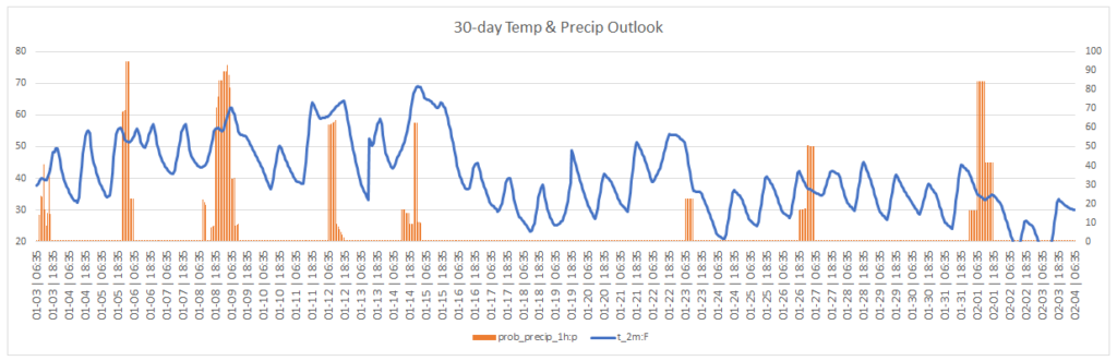
The Euro Weeklies model made its first turn colder last night. IT now suggests chilly weather for the region starting around the 23rd of January with a bigger shot of colder air arriving as we move into February.
But that is about all we can garner from this. I don’t put much stock in specific temperatures or precipitation chances.
Of note: This is also likely to change tonight.
But if you watch it, daily, you can pick up on trends and start to get a feel for how things may eventually shake out.
The bottom line is: Cooler is more likely than warmer for late January. But beyond “cooler” there isn’t much else we can say right now.
REGIONAL DAY-TO-DAY FORECAST
Thursday: Sunny. Highs in the mid 50s. North winds 5 to 10 mph.
Thursday Night: Mostly clear. Lows in the mid 30s. Northeast winds around 5 mph.
Friday: Partly sunny in the morning, then cloudy with rain showers in the afternoon. Highs around 60. East winds 10 to 15 mph with gusts up to 25 mph. Chance of rain 90 percent.
Friday Night: Cloudy with rain and storms possible. Locally heavy rainfall possible. Lows in the upper 40s. East winds 10 to 15 mph with gusts up to 30 mph, becoming southwest 5 to 10 mph after midnight. Chance of rain 90 percent.
Saturday: Mostly cloudy in the morning, then becoming partly sunny. Highs in the lower 60s.
Saturday Night: Mostly cloudy. Lows in the lower 40s.
Sunday: Partly sunny. Highs in the lower 60s.
Sunday Night: Mostly cloudy. Lows in the lower 40s.
Monday: Mostly cloudy with storms possible. Highs in the mid 60s. Chance of rain 70 percent.
Monday Night: Showers with a chance of thunderstorms. Breezy with lows in the lower 50s. Chance of rain near 60 percent.
Tuesday: Partly sunny. A chance of showers, mainly in the morning. Breezy with highs in the lower 60s. Chance of rain 30 percent.
Tuesday Night: Partly cloudy. Much cooler with lows in the mid 30s.
Wednesday: Mostly sunny. Highs in the mid 50s.


