It is a cloudy and cold start to your Wednesday. I’ve received a few reports from folks of snow mixing in with the rain this morning in a few spots near McComb, Brookhaven, Prentiss, and Magee. A few other folks across parts of Jones County said they saw some snow this morning, too.
Radar was lit up like a Christmas Tree, too. The cool thing about melty snowflakes is they send back a lot of energy to the radar, so it makes it look like it is pouring down rain in places that it may only be drizzling or have a light wintry mix.
As we move through the rest of the day, things should remain as regular rain. A cold rain, but rain.
Our attention turns to the next system that will zip through the region on Friday and into Saturday morning. This system should pass through pretty quickly. I think Friday during the daylight hours should be mostly dry. Same with Saturday. But overnight the rain will move through.
Model guidance keeps the surface warm front along the coast or out into the Gulf with this next system. That will help to keep the severe weather threat to a minimum.
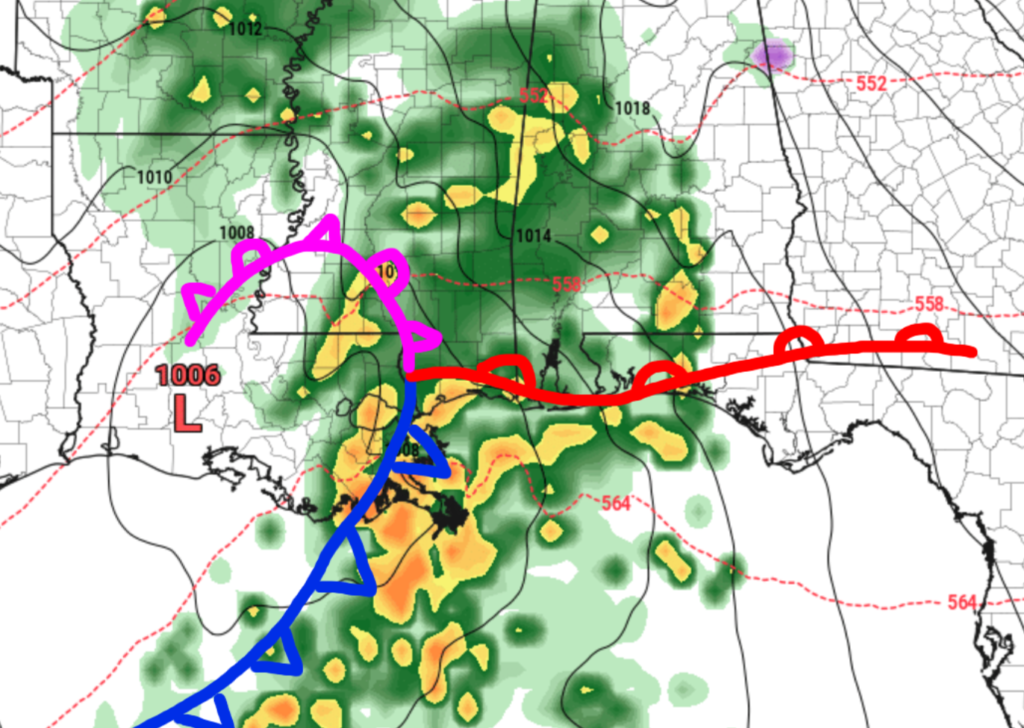
While we can’t rule out brief shots of heavy rain and thunder, the tornado threat is basically zero. And wind gusts should be held to under 35mph.
Behind this system it doesn’t look to be terribly cold, either. High temperatures on Saturday will be around 55F to 60F which is about normal for this time of year.
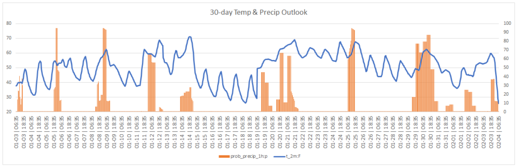
Since we are moving toward Parade Season, Mother Nature is having a parade of her own, because after this system rolls through, the next system is set to push through early next week.
And the parade keep rolling through all of January and into February. Looking at the 30-day outlook for the area, we will see a quick shot of cooler weather around the middle of the month and then rebound quite a bit warmer. But the parade of rain, shown by the orange areas which highlight when precip is most likely, looks to offer a shot for meaningful moisture every 3 to 5 days for the next month..
Notice that this outlook does not include the massive cooldown that is floating around social media. I covered this a few days ago, but I think it is worth showcasing again because those posts continue to circulate: Free to see computer weather model guidance that looks that far into the future is not accurate (that’s why I pay for access to the good stuff for you guys).
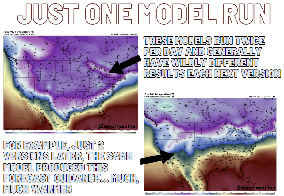
But on top of that, the model that created the map that is floating around isn’t designed to produce accurate spot temperature data. It is more for ‘big picture’ stuff.
So rest easy, the likelihood of single digit temperatures across the region in late January is quite low. Cold may be coming! But that cold? Not likely. And if it does come to be, it wasn’t because that one model run was “right” but rather the case of “a blind squirrel finding a nut.”
REGIONAL DAY TO DAY FORECAST
Wednesday: Showers, cooler with highs in the upper 40s. Northeast winds 10 to 15 mph. Chance of rain near 100 percent.
Wednesday Night: Mostly cloudy in the evening, then becoming partly cloudy. Lows in the lower 30s. North winds 5 to 10 mph.
Thursday: Sunny. Highs in the mid 50s. North winds 5 to 10 mph.
Thursday Night: Mostly clear. Lows in the mid 30s. Northeast winds around 5 mph.
Friday: Increasing clouds with a chance for showers and storms in the afternoon and evneing. Highs in the lower 60s. Chance of rain 40 percent.
Friday Night: Cloudy with showers and storms possible. Temperature in the mid 50s. Chance of rain 70 percent.
Saturday: Partly sunny in the morning, then clearing. Highs in the lower 60s.
Saturday Night: Partly cloudy in the evening, then becoming mostly cloudy. Lows in the lower 40s.
Sunday: Mostly sunny. Highs in the lower 60s.
Sunday Night: Partly cloudy. Lows in the lower 40s.
Monday: Partly sunny with showers and storms possible. Highs in the mid 60s. Chance of rain 60 percent.
Monday Night: A chance of thunderstorms. Showers. Locally heavy rainfall possible in the evening. Breezy and not as cool. Near steady temperature in the upper 50s. Chance of rain 40 percent.
Tuesday: Partly sunny with showers and storms possible in the morning. Breezy with highs in the lower 60s. Chance of rain 30 percent.


