A handful of folks have asked what I do now. Aasking why I left TV and if I’m still even doing anything with the weather.
There are many ways to explain what it is that I do now, but I think showing an example would be the easiest. Since I do a lot of different kinds of weather forecasts these days, I wanted to share an example of something that is close to – but not exactly like – a forecast I would/have perhaps send/sent to folks I work with these days.
This is a just a typical tropical weather forecast. But once (sometimes twice) per week I like to send one out with a theme. This week, with Tropical Storm Larry, I went with a Larry David theme. A few weeks ago it was The Big Bang Theory, I’ve used a few Star Trek references, and some Simpsons, and even one that featured 80s movies only.
But you may be asking, how do you theme a forecast?

Take a look:
The NHC has tagged that cluster of storms in the Caribbean has been dubbed Invest 91L. I can say that I personally appreciate the NHC designating this little area because it allows the tropical models to be run on it. That helps get a better idea of where it is heading.
Where is it heading?

Not far.
Most model guidance slides this thing into Central America while a few – very few – ensemble members try to hold 91L together into the Bay of Campeche. Though, there are, like, less than five different members that keep it , at all, intact, so I’m not concerned. Because, to be honest here, when even the ensembles are not all that enthusiastic, you know it is in trouble. Above and on the left is the EPS ensembles showing one little curly-cue that gets into the Bay of Campeche, while on the right the GEFS shows only two.
So the chances are, not great.

Eventually some piece of it may make it toward the Gulf. But at that point it will be a shell of its former self. I think it is interesting that if it does hold together, but remain disorganized, the prevailing flow would try to draw it close to the northern Gulf coast eventually.

On second thought, me either.
Alright. Now, let’s have a chat about whatever is left of whatever was Kate. . .

And. . .

Okay! Let’s talk about Tropical Storm Larry.
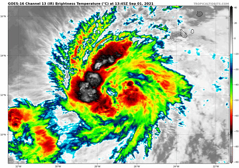
Larry is actually looking pretty good. It is currently roaming the open waters of the Atlantic and not bothering anyone. This is the best kind of tropical system. And there is a good chance it continues moving west-northwest for the next 72 hours before curling north. Staying out to sea.
But if you ask me if I’m 100-percent confident this things stays out to sea, I am not.
That ridge of high pressure that is building across the Atlantic from east to west continues to inch farther and farther west in the guidance. It is something that start a few days ago. And that continued again yesterday and again today. Recall that tropical systems ride around the edge of large areas of high pressure. So wherever the high drifts, Larry will drift around. .
And it did so on both the EPS (left) and GEFS (right) computer weather models.

Individual ensemble model members so show this thing ‘making the turn’ by Day 7. So there is that. But that turn continues to inch farther and farther west. As the system will just ridge around the edge of that ridge. Below, and on the left is today’s model run. On the right is from Saturday. The cluster was a little closer to 50W and is now a bit closer to 60W.

There is some good news here, though.

The good news is we are still talking about something to watch that is seven days from now. And even more could change between now and then – either good for us or bad for us. So it bares watching. While I find it very unlikely it makes it to the Gulf, there may be some folks on the east coast that need to keep an extra eye on Larry.
Of course, the final track will depend on how the high pressure situation plays out.
So, how do I feel about Larry?

Reasonably okay?
That isn’t an exact word-for-word forecast update. But close. GIFs and all.
It is nice to be able to have some “fun” while putting together a forecast and to work at a place that allows – and actually encourages – this type of thing. Plus I’ve found that people are much more apt to read and digest the information when it is presented in a “fun” way.
I even take the time most days to add in some extra tidbits and explainers. Just like I tried to do at WDAM.
One of my biggest hurdles at WDAM – and even KAMR before that – was always trying to make the point that we can remain professional and also have fun without looking foolish. It is a difficult line to walk, sure. Particularly on TV. But it is one worth trying to walk. Because life is heavy and its important to have fun when it is allowed.
A lot of people ask if I’ll ever get back into TV. Maybe. But I have to say that TV is a dying medium. And I can reach every single one of you on this blog just the same! So it makes me think that TV may not be in my future. For that reason, and others.
Hopefully you enjoyed this peek behind the curtain!


Huge fan of your work and writing style. Thank you for all you do for South MS. You make weather interesting and make me more knowledgeable. What you have is a God given talent and it’s a joy to watch you. I love watching people really enjoy their passions.