Good morning, and Happy Sunday! Hope this weekend has been full of rest, and college football (if you’re into that). I know I was excited to see it return yesterday.
Wet is still the name of the game over the next week, that much hasn’t changed. As I alluded to in the last forecast, it won’t be quite as much rain as we saw earlier in the week, but storms are still likely across much of the area.
As we stand right now, a large area of high pressure over the Atlantic is keeping Southerly flow over our area, advecting warm moist air into the region. In addition, there is a long string of vorticity being advected into this area. This can be a source for rising air, and then, thunderstorm formation.

That colorful zone over the Gulf Coast and extending out into the Gulf is the vorticity region we’re watching come onshore, and will probably lead to unsettled weather, while not being as strong as the troughing we saw last week.
With this Southerly flow, we mentioned seeing a lot of warm and moist air. Here’s a look at the PWAT values that are expected for this morning.

You might notice that these aren’t as high as they have been-and that’s completely correct. We’ve seen a lot of the atmospheric moisture decrease over the past few days. This means that when it does rain, the rainfall won’t be as “efficient”, and the rainfall rates won’t be as high.
With that being said, heavy rain is still possible, but we probably won’t see nearly the same rainfall rates as last week. Good news, if you ask me.

The HRRR develops spotty convection across the area this afternoon. Dry air entrainment aloft could lead to some scattered strong wind gusts, but that’s no different than most summer days, and we aren’t concerned about severe weather.
With the rain and storms in the area, temperatures will remain slightly below average, and we shouldn’t really get any higher than 90F this week.
High temperatures also struggle to increase very much when the ground is very waterlogged, and I don’t need to tell you, it definitely is very waterlogged at this point in time.
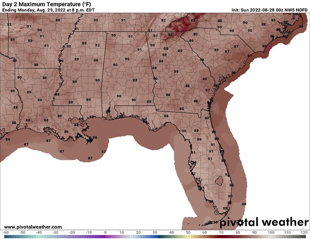
The Weather Service is forecasting highs just below 90F for today, and that’s the theme for most of the upcoming week. Areas that see rain and storms will get a nice cooloff, and might top off in the low 80s if the timing is right.
The 7-day rainfall outlook is still showing around 1-2” of rain across most of the area. Further South, where the sea breeze takes effect, and the enhanced moisture is located, those rainfall totals will be slightly higher. Either way, it should be pretty spread out over a long period of time, so flash flooding isn’t expected.
Since we’re talking about good news, it’s worth mentioning that most of the rivers in the area have already crested, or are going to crest today or tomorrow. The Pearl River is running high and still has more to gain, but most of the other rivers should be going down. Hopefully, it will do so without incident.
With all of that being said, the CPC 6-10 day outlook isn’t too surprising.

Cooler and wetter weather is going to continue across the area. I think back to the hot summer, and I’m not mad about this at all. I am upset that my clothes and shoes keep getting soaked, but that’s just part of living in the Southeast.
As this is my last forecast for NickelBlock, I seriously want to thank all of you who read and hopefully used my forecasts. It’s been a great honor to work with Nick, and learn about forecasting for this region.
It’s been just the experience I needed (and one heck of a resume booster!) I hope that one day you’ll hear from me again, at the National Weather Service. That’s always been the goal and I’m glad to work on getting there with you all. Thanks for choosing NickelBlock, and keep checking back for more!
Anyways, on to my last forecast.
Day-to-Day Forecast
Today
Mostly sunny in the morning, with increasing clouds and a 60-percent chance of showers in the afternoon. Highs in the upper-80s.
Tomorrow
Mostly sunny, with a 60-percent chance of afternoon thunderstorms. Highs around 90F. The Heat Index may reach 103F.
Tuesday
Partly cloudy, with a 70-percent chance of afternoon thunderstorms. Highs in the upper-80s.
Wednesday
Partly sunny, with a 60-percent chance of afternoon thunderstorms. Highs in the upper-80s.
Thursday
Mostly sunny, with a 30-percent chance of afternoon thunderstorms. Highs in the upper-80s.
Friday
Partly cloudy, with a 40-percent chance of afternoon thunderstorms. Highs in the mid-80s.
Saturday
Partly cloudy, with a 60-percent chance of afternoon thunderstorms. Highs in the mid-80s.


Y’all did a great job! Most days it was difficult to determine if Nick was forecasting or you. We need the best to keep us safe, and, in my opinion, that is your category!