Aside from a post here and there, today is the last day you’ll read a “regular” summer forecast from the interns. Man! It seems like they just started! They grow up so fast. Where does the time go?
As noted in the title, now I understand how you parents feel. All the sudden, one day, you turn around and your kids are all grown up!
The students did a fantastic job this summer. I’m really proud of the hard work they put in and I’m excited to see where they end up in the future.
But as much as you guys want to read about me bragging on my interns, you probably also want a weather forecast…. So here we go!
Rain is the main story. Still. But I know the interns are going to talk about that. Instead I want to toss out some info on our big puzzle pieces in the sky that will be dictating a lot of the weather during the next few days.
By Wednesday, we will have a ridge tot he west and another to the east. As shown on the map the blue arrows are how the wind circulates around the ridges of higher pressure in the mid-levels of the atmosphere. Those arrows tell us how any storms systems in the region would move around

The black dashed lines are the “fences” between the two ridges where anything in the tropics would likely travel if – big if – there was anything out there. At this point, there shouldn’t be on Wednesday. Unless the little area in the Caribbean gets its act together. But at this point, it looks to be so far west that it is more likely to be a problem for Mexico.
By Sunday, the ridging takes over most of the eastern 2/3rds of the country. Now the fence is pointing things toward the Gulf of Mexico.
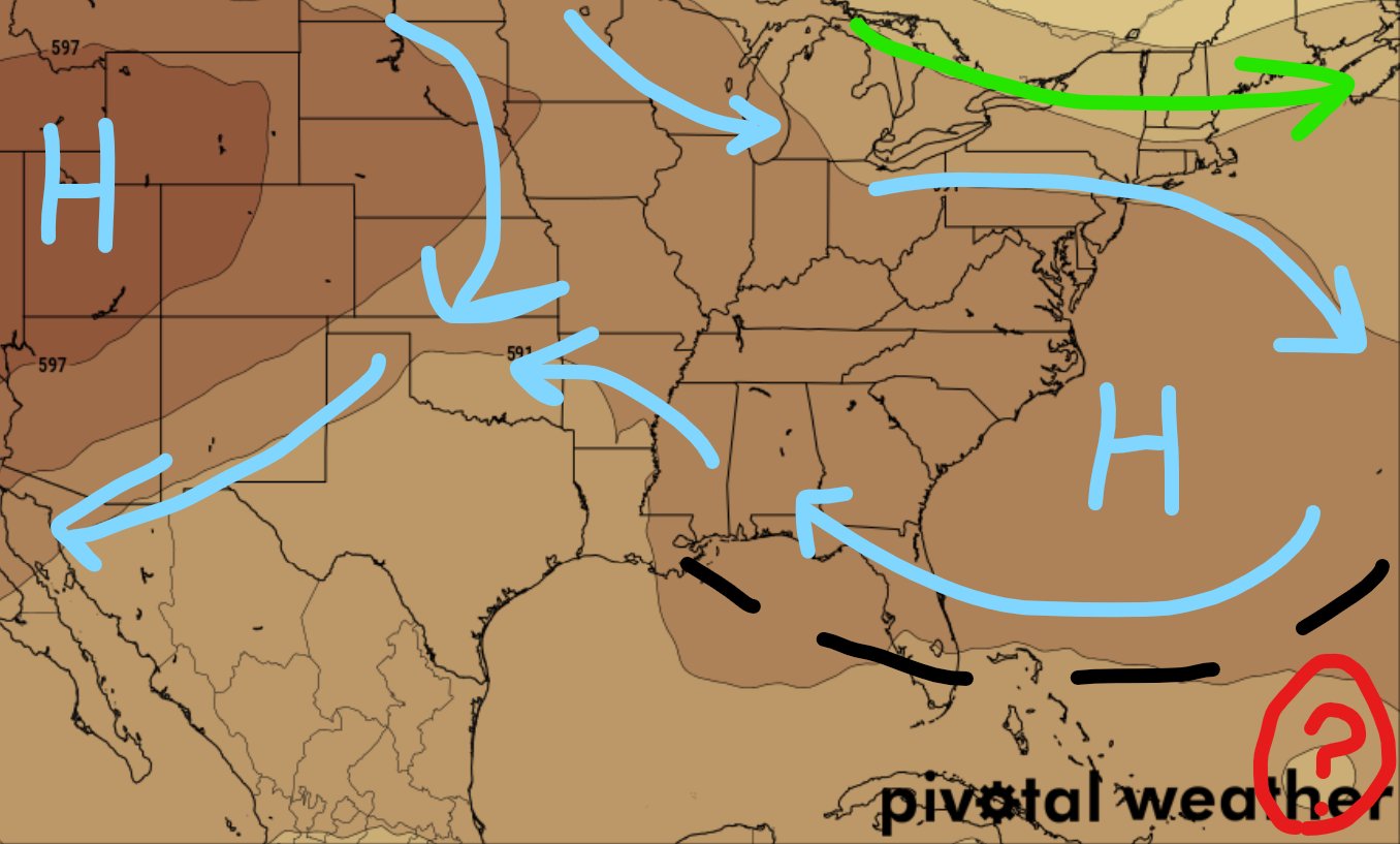
And the little “?” in the bottom right corner is where model guidance anticipates Invest 91L to be at this point. Oh, right! The tropical wave in the Atlantic was minted a new designation overnight. It is now Invest 91L. Recall that the NHC does this in order to run all of their special weather models related to the potential path and strength of potential tropical systems.

Back to the forecast: So, by Sunday, the puzzle pieces of the atmosphere, from this one model, are pointing the path of the storm toward the Gulf.
You may say, “Oh no!” But hang tight. While the GFS model shows something similar, both models also show something helpful, too.
Both models show troughing eroding away at the ridging across the eastern 2/3rds between this Sunday and next Wednesday. That moves the “fence” all the way back toward the Rockies. But it also means there is nothing stopping it from moving north and staying out to sea.

And the same time, That big trough would also mean some slightly cooler temps (Keyword here is “slightly”) and continued chances for rain.
But that is what we are watching in the coming days. The interaction between two ridges of high pressure and how that ends up playing a role in the movement of Invest 91L. On top of that, the movement will help to warm things up slightly and then cool things back down slightly durin gthe next 10 days.
Day to Day Forecast
The interns are tackling these on last time. Isaiah and Alexis are here with a look at the forecast for SE MS / SW AL and the Coastal counties of MS / AL as well as the parishes of Louisiana. Tap the headlines below for a full breakdown of the local forecast!


