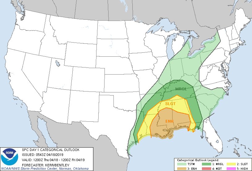
The Storm Prediction Center has released their first Day 1 Risk Outlook for the severe weather potential on Thursday (today). Take a look:
Locally, the threats and the forecast hasn’t changed much from earlier today – even with some of the overnight data. It still looks like heavy rain, localized flooding, frequent lightning, wind gusts up to 70mph, hail up to the size of quarters and tornadoes – some stronger than EF-2 – are possible, too.
The timeline is still from 2pm through 10pm for South Mississippi.
Here is the breakdown from the Storm Prediction Center:
…THERE IS AN ENHANCED RISK OF SEVERE THUNDERSTORMS TODAY INTO TONIGHT ACROSS PARTS OF THE CENTRAL GULF COAST STATES…
…SUMMARY…
Severe thunderstorms are possible today across the lower Mississippi Valley through the central Gulf Coast states, accompanied by the risk for damaging wind gusts and a few tornadoes, some of which could become strong.…Synopsis…
An amplification within the large-scale mid/upper flow now progressing inland of the Pacific coast appears likely to translate downstream, through the Mississippi Valley, where a deepening mid-level trough is expected to evolve by 12Z Friday. One significant short wave trough and mid-level low, already progressing through the southern Plains, appears likely to become increasingly sheared while accelerating across and northeast of the mid/lower Mississippi Valley vicinity. This may include one prominent embedded perturbation, associated with extensive ongoing convection across central/eastern Texas, which is forecast to pivot through the lower Mississippi Valley by late this afternoon. Thereafter, a significant upstream short wave trough, digging to the lee of the Rockies, is forecast to continue southeastward into the lower Mississippi Valley, where another embedded mid-level low may begin to evolve by the end of the period.
Models indicate primary low-level cyclogenesis during this period will accompany the lead perturbation, with a deepening surface low center probably migrating from east Texas through the lower Mississippi Valley, toward the western slopes of the central Appalachians. Considerable convection, and associated surface outflow, are expected to precede the trailing cold front across the lower Mississippi Valley and central Gulf Coast states.
While the low-level environment across much of the Southeast may be initially dry and or stable, models continue to indicate an influx of seasonably high boundary-layer moisture off the western Gulf of Mexico, across parts of the lower Mississippi Valley and central into eastern Gulf Coast states. The extent to which this precedes the eastward advancing convective outflow remains unclear, but potential exists for sufficient destabilization to support re-intensification of thunderstorm activity, with the evolution of an organized squall line accompanied by potential damaging wind gusts and a few tornadoes possible.
…Lower Mississippi Valley/Central Gulf Coast states…
Some uncertainty exists concerning how quickly thunderstorms will redevelop and intensify along eastward advancing outflow generated by ongoing thunderstorm activity now spreading through eastern Texas. There appears likely to be at least some stabilization of mid-level lapse rates. However, guidance indicates that southerly 850 mb flow may strengthen in excess of 50 kt, inland of the Louisiana coast through Mississippi, as early as the 18-21Z time frame. This probably will be accompanied by a corridor of considerable boundary layer moistening, with guidance indicating surface dew points increasing through the upper 60s to near 70 F as far north as at least much of southern/southwestern Mississippi, contributing to CAPE of 1000-1500 J/kg.Aided by strongly difluent and divergent upper flow, and strong vertical shear, a gradually intensifying and organizing squall line is expected to be accompanied by increasing potential for damaging wind gusts, and perhaps a few embedded tornadoes. As the convective system advances eastward, it may be preceded by discrete supercell development, and a weak warm frontal zone, which may provide the focus for large clockwise curved low-level hodographs supportive of a risk for tornadoes. A couple of these could become strong, perhaps as far east as southeastern Alabama by late tonight.
..Kerr/Bentley.. 04/18/2019
As a reminder, and as I’ve tried to kind of harp on, this forecast for severe storms isn’t a “Slam Dunk” by any means. And, let’s be real, even those can go awry.
New stuff / Good news
I want to start with the good news because there is some. It isn’t great news, but it is a subtle nuance-ish type thing that could be the start of a trend.
The storms under-performed today
Storms in Texas didn’t produce the expected large hail and weren’t as robust as expected. Honestly, I’m not completely sold that this is good news, but I’m putting it here anyway. Because there are two outcomes that can come of this, either (A) they weren’t as robust and the models are over-doing the threats for these storms and the ones headed toward Mississippi OR (B) The storms underperformed today, meaning they won’t make it as far to the east and that’ll leave our atmosphere untouched and even more ripe for the development of severe weather.
We will need to watch how things evolve overnight tonight and how fast some of these storms lose steam.
Forecast soundings in the pre-frontal, near storm environment aren’t looking as favorable
It is a small shift, but perhaps a worthwhile one to note…

The above image is from the 3z HRRR model. It is the forecast sounding showing a whole bunch of atmospheric data for Thursday afternoon out ahead of the storms. This is known as the “pre-frontal environment” in the weather world. It is also the “near storm environment” in this case.
There is a subtle difference between this sounding and say, this one from just 24 hours ago.
I’ll give you a second to look both over (if you choose).
Let’s zoom into the important part of the graphic posted above (not the link, the one actually on this page)…

The above image is a look at the hodograph from the HRRR, our super short-range computer weather model. The line, when trying to produce significant severe weather, should look like a sideways fish hook or a sickle. Notice, though, how the hodograph looks more like an “M” a toddler would draw. That little hiccup in the middle may be juuuust the thing needed to help keep severe weather in – relative – check in south Mississippi.
We didn’t we catch this earlier? And why did it look different? Well this is data, that sadly, we just can’t get a sharp enough resolution on from other model data. We have to be within about 18 hours of an event to see this stuff.
As an aside: this is why you never hear me say anything with severe weather is “likely” until about 12 to 18 hours out. We just can’t know some things. and I have to be honest about what we do and don’t know – with myself and with you guys.
Looking north of I-20, the hodograph looks smoother.

That doesn’t put south Mississippi in the clear. Not even close. But it is a kink in the chain, for sure. It just means that storms will have to overcome a bit more to get going in our area. Not much, but some.
And, hey, every little bit helps.
Let’s all hope this is the start to a trend, too. And not just a hiccup in the data.
Building a composite of data from the last 36 hours
Because hoping isn’t a plan and one or two model runs isn’t a trend yet…. We need to plan based on the available data from the previous 24 to 48 hours.
As the overnight model data continues to come in, I’ve taken a quite bite out of the proverbial consistency-between-the-models apple. I went back and looked at all over the “convection allowing models” Updraft Helicity tracks and laid them all on top of eachother and tried to find where the most common area was for tracks to occur.

Try not to get too caught up in the false-specifics offered here. I know it is tempting! This is not showing that some people have a risk and others have zero risk.
The entire area is under an Enhanced Risk from the Storm Prediction Center. So, the above map isn’t replace that SPC Risk. Think of it as a topping. The Risk area gives the overall risk, while this map shows a few areas that may see the strongest storms within that Risk area.
This is all great, but just tell me what will actually happen, Nick
I can’t. Unfortunately, I’m not a psychic. If I was, I’d win the lottery. Every week.
All I can do is offer a forecast. And the forecast I posted at the top is the forecast – and it takes all of this data into account.
It still looks like heavy rain, localized flooding, frequent lightning, wind gusts up to 70mph, hail up to the size of quarters and tornadoes – some stronger than EF-2 – are possible, too.
The timeline is still from 2pm through 10pm for South Mississippi.
The “Good news” showing a possible shift in the parameters lowering the severe weather threat is still good news. Absolutely. But there isn’t enough evidence available (yet) to change the forecast. Because all of the available data up until this point has said severe weather is possible. So don’t let your guard down.
We will continue to monitor the data overnight and assess things in the morning and through midday.


