For the past couple of weeks, much of the CONUS has been experiencing two extremes: excessive rainfall leading to dangerous flooding and worsening droughts with above average temperatures. On the other hand, monsoonal moisture has persisted and brought improvement to the drought conditions in the Southwest.

Subtropical ridging is the main influencer of the weather over the CONUS keeping temperatures above average for most of the U.S. and the overall steering pattern slow, causing any disturbances to move very slowly posing flooding risks.

The location of this ridge has brought the above average temperatures to the Great Plains and is expected to continue for at least the next 7 days as the ridge persists and begins to strengthen/amplify farther west by mid next week. The Climate Prediction Center of the National Weather Service has stated that it is likely for the above temperatures to continue into the 6-to-10 day timeframe, especially in the Upper Plains.

A weak area of low pressure over Kentucky is causing unsettled weather in portions of the Midwest and Southeast today. Nearby an axis of high pressure extending from Virginia to Mississippi from the Atlantic ridge which will cause the low pressure system to drift very slowly which has warranted a slight flooding risk around the Southern Appalachians.
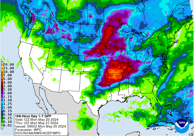
Overall, parts of the Midwest, Southwest, and Southeast will receive heavy rainfall over the next several days while the Plains and Pacific Northwest remain dry.
Drought Developments and Improvements

Monsoonal moisture has continued to make its way into the Southwest over the past month and has brought many benefits to the region despite the flash flooding, including drought conditions lessening and complete removal of the drought becoming likely by the end of this month; however, parts of the Pacific Northwest and Great Plains haven’t seen any substantial rainfall in months, and the droughts there are expected to persist.

Much of the Southwest still remains under extreme drought conditions, but with the help of the monsoon, these conditions will continue to improve over the course of the next couple of weeks.
For the most part, much of the U.S. will experience above average temperatures and dry conditions the next 7 days including the Great Plains and Pacific Northwest while others receive an abundance of rainfall (the Southwest, Southeast, and portions of the Midwest).


