Happy Saturday folks! Expect skies to be mostly clear early this morning becoming partly cloudy before noon as the Sun begins to heat the surface and cumulus clouds develop. Showers and thunderstorms may arrive a bit earlier than usual today but should pass quickly leaving the afternoon and evening mostly dry. Temperatures will reach the lower 90s today in combination with dew points around 75F, which will allow heat indices to approach the upper 90s.

High pressure at 500mb still dominates most of the U.S. but there are a few more moving parts included in the equation today: a weak cutoff-low pressure system over Kentucky drifting west-southwestward, an inverted trough/wave off of the coast of the Carolinas (as denoted by the dashed lines) drifting westward, and the axis of the Atlantic high pressure that extends from Virginia to Mississippi. The inverted trough is the main feature set to impact Coastal LA/MS/AL as it will bring a surplus of moisture and unsettled weather early next week with increased chances for rainfall.

Southeasterly and southerly low-level winds have been and will continue to supply ample moisture to the coast of LA/MS/AL over the next 7 days. With this moisture in place, daily thunderstorms are likely to affect the coast and surrounding areas with heavy rain and frequent lightning. These will primarily be pop-up thunderstorms that pass quickly, but some thunderstorm clusters may develop bringing gusty winds.
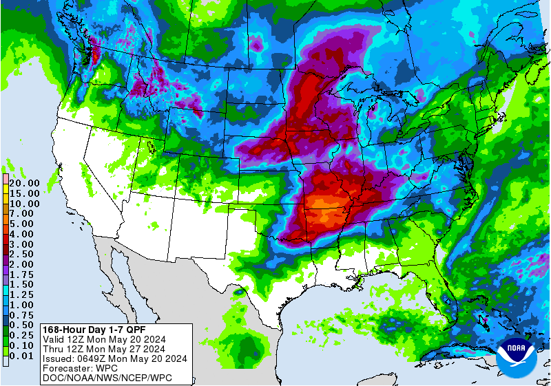
As the inverted trough and southerly low-level moisture feed overlap next week, and in combination with diurnal heating, rainfall amounts of 1″-2″ are expected to impact most of the forecast region, with some areas potentially reaching 3″ over the next 7 days.
Day to Day Forecast
Today
Partly cloudy with a 60-percent chance for showers and thunderstorms in the morning/afternoon. Highs in the lower 90s. Heat Index values around 98F.
Tonight
Partly cloudy. Lows in the lower 70s.
Sunday
Partly cloudy with a 70-percent chance for showers and thunderstorms. Highs in the lower 90s. Heat Index values around 97F.
Sunday Night
Mostly cloudy. Lows in the lower 70s.
Monday
Partly cloudy with a 70-percent chance for showers and thunderstorms. Highs in the upper 80s. Heat Index values around 96F.
Monday Night
Partly cloudy. Lows in the lower 70s.
Tuesday
Partly cloudy with a 80-percent chance for showers and thunderstorms. Highs in the upper 80s.
Tuesday Night
Partly cloudy. Lows in the lower 70s.
Wednesday
Partly cloudy with a 70-percent chance for showers and thunderstorms. Highs in the upper 80s.
Wednesday Night
Mostly cloudy. Lows in the lower 70s.
Thursday
Partly cloudy with a 60-percent chance for showers and thunderstorms. Highs in the upper 80s.
Thursday Night
Partly cloudy. Lows in the lower 70s.
Friday
Partly cloudy with a 60-percent chance for showers and thunderstorms. Highs in the lower 90s.
Friday Night
Mostly clear. Lows in the lower 70s.


