I’ve heard from a lot of my Panhandle friends recently asking about the threat for severe weather Saturday. The Storm Prediction Center has pegged parts of the area with a Moderate Risk for severe weather. That is a 4-out-of-5 on the 1-to-5 scale, where 5 is the highest risk for severe weather.

The SPC has broken down the threats to both tornadoes and hail for today.


Here is the discussion from the SPC:
…Southern High Plains through early tonight…
A deep closed low over AZ will progress eastward to the southern High Plains by the end of the period. In association with an embedded jet streak rotating northeastward around the eastern periphery of the low, a surface cyclone will develop north-northeastward from the TX Panhandle this afternoon to southwestern KS tonight.
The cyclogenesis will draw the surface warm sector northward across western OK and the TX Panhandle today to the east of a developing dryline, which will focus severe storm development this afternoon/evening.
Some elevated convection is expected this morning from northeast NM northeastward into southwest KS, within the exit region of the mid-upper jet. Midlevel lapse rates/buoyancy will be sufficient for isolated large hail with this convection. Farther southeast and following a lull in the overnight convection, the warm sector will spread northward today, beneath midlevel lapse rates greater than 8 C/km.
Moderate buoyancy (MLCAPE of 1500-2000 J/kg) is expected south of the warm front and east of the dryline this afternoon, with only weak convective inhibition along the dryline. Initial storm development is expected early-mid afternoon along the dryline in the vicinity of I-27 in TX Panhandle/South Plains.
These initial storms will move off the dryline and maintain more discrete character as they encounter a moist, destabilizing warm sector with strong vertical shear. Given boundary-layer dewpoints in the low 60s, afternoon temperatures of 65-70 F, effective bulk shear near 70 kt, and effective SRH in excess of 250 m2/s2, there will be a few hour window for a couple of supercells to produce long-track, strong tornadoes and very large hail across the east central/southeast TX Panhandle.
West of the initial supercells, squall line development is expected by evening as a Pacific cold front overtakes the dryline and the stronger height falls/ascent overspread the TX Panhandle and west central TX.
Embedded supercell structures within the line will be capable of producing all hazards, though the overall severe threat will weaken with eastward extent during the early overnight hours, as a result of diminishing buoyancy.
Courtesy: spc.noaa.gov
Quick breakdown
As the dryline mixes east, showers and storms will fire along the dryline and have a robust environment to work within. Model guidance suggests that most of the tornado-producing parameters will be met this afternoon off the caprock and across some of the eastern counties of the Texas and Oklahoma panhandles.

Comparing the numbers from that Skew-T against the historical tornado environment data from the SPC (below) you can see why the SPC has issued the Moderate Risk.
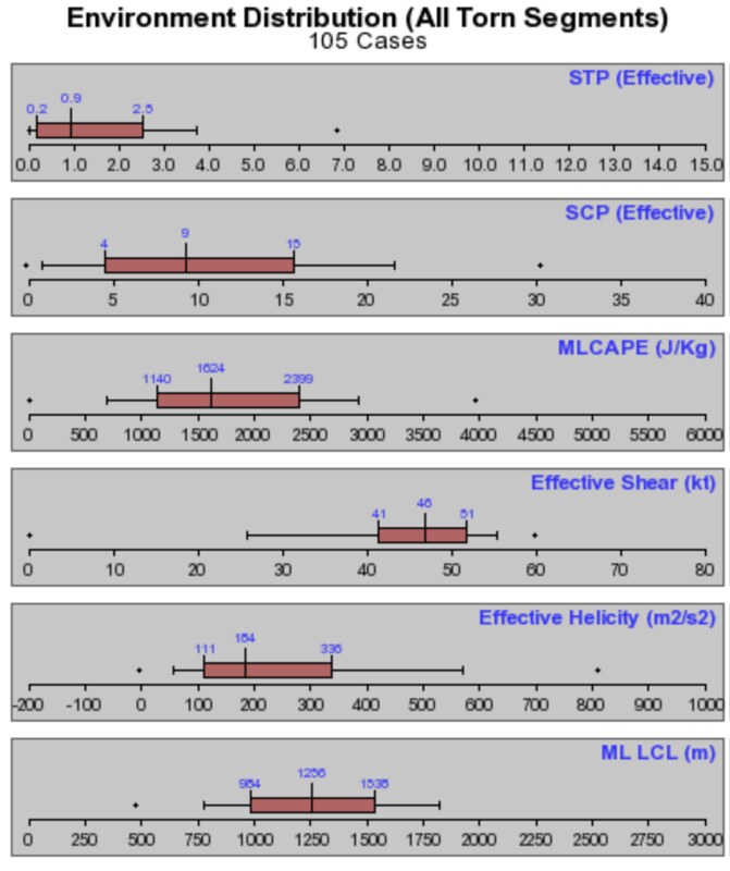
The numbers pulled from the Skew-T fall within the interquartile range for tornadic events. All but the last one, the ML LCL (Mixed Layer Lifted Condensation Level), which is much lower. But, in the case of ML LCL, a lower value means it is a bit easier for the atmosphere to produce a tornado.
In this particular case, would not be surprised to see very large “mesos” with wall clouds very close to the ground and tornadoes not as visible as they usually are for the Panhandles. This, coupled with the other parameters, also lends credence to the increased threat for strong tornadoes today.
Main Threats & Timeline
Today the main concern will be for heavy rain at times that may lead to localized short-term flooding, frequent lightning strikes, wind gusts up to 70mph, hailstones up to the size of baseballs, and tornadoes. There is also the potential for strong tornadoes (EF2 and EF3) today.

The timeline for severe weather will be between 11am and 9pm for most of the area. A wide timeline, I know, but this may be a longer-term event.
The Bottom Line
If you live across parts of the Texas and Oklahoma panhandles today, have a severe weather plan. Have your NOAA Weather radio programmed and turned on. Have a good weather app on your phone. And keep an eye to the sky.
Underneath the SPC risk for severe weather, based on the latest available data from some of the shorter-range guidance, I would suggest that these area have the highest risk for the most significant severe weather:

That doesn’t necessarily mean that that is where the only large tornadoes will be, or the only places that will see baseball-sized hail. Instead it suggests that if you live inside of the orange – or red – circles, please be extra aware of the weather today.
When the NWS issues a tornado warning for your area, take cover until the warning ends. And take cover inside of a sturdy building – or underground if possible.


