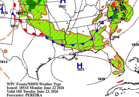
The next couple of days have afternoon and evening scattered storms in store for us. Winds aloft will be blowing out of the northwest, allowing several disturbances to ride those winds into our area. There’s also a nearby cold front, with rain and storms developing along it as it pushes southeast through Wednesday.
Together, these features will help spark scattered showers and thunderstorms each day from Tuesday through Thursday.
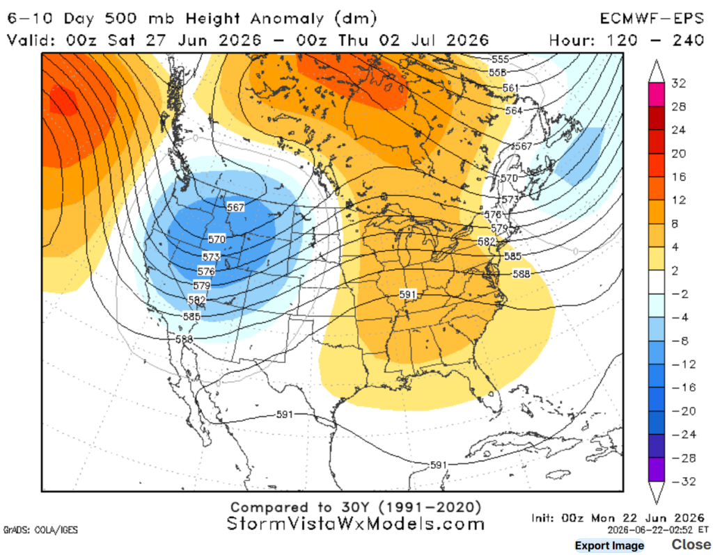
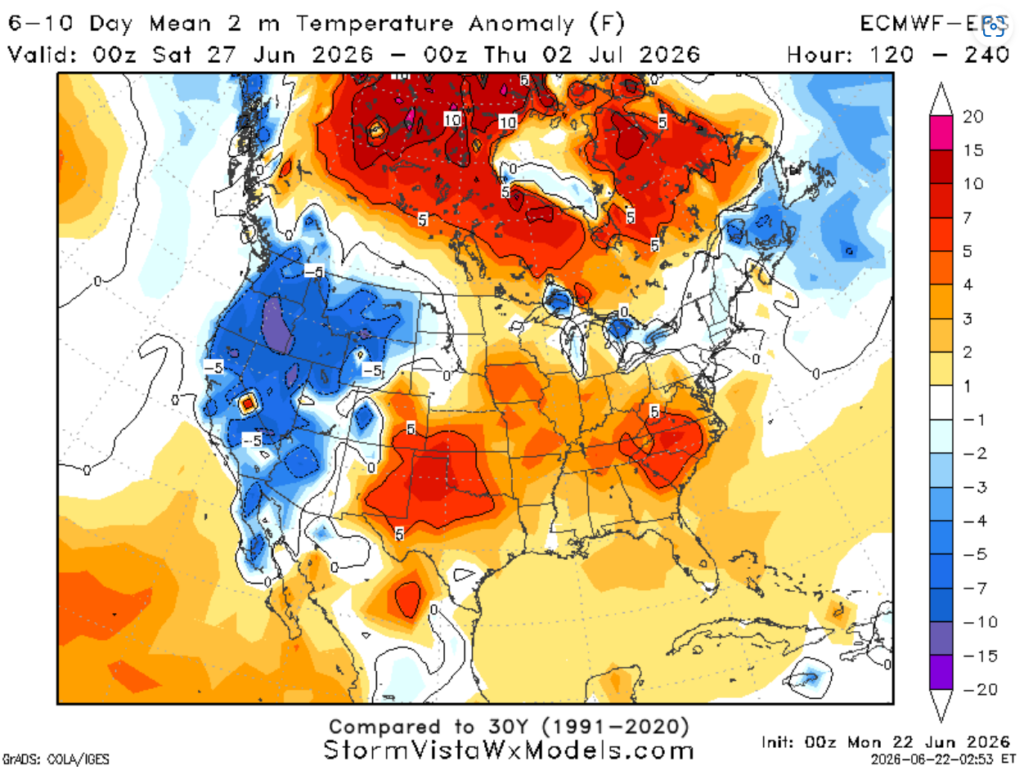
As we head into the weekend, ridging will shift eastward and build over the southeast, which is clearly shown in the 500 mb anomaly composite map below (left). For our region, this transition will take us from near-normal to above-normal temperatures, so keep an eye out for possible heat advisories that may be issued this weekend.
Overall, it looks like a nice weekend ahead, with mostly sunny skies expected across the region, and of course we can’t rule out an evening isolated storm near coastal cities.
3-DAY TRAVEL FORECAST
AIRPORTS
KIAH / KHOU (Houston) – No weather related issues anticipated through Wednesday.
KSHV (Shreveport) – Flood watch in effect tonight. Scattered showers and storms will continue through the night and into Tuesday morning. Watch for minor flooding on roadways, and intermittent flight delays are possible tonight. Flights after 10 AM tomorrow should be not be impacted by weather.
KBTR (Baton Rouge) – Low-end chance for afternoon showers and storms possible each day. Some intermittent flight delays are possible for lightning. But most flights between 10a and 4p should be not be impacted by weather.
KMSY (New Orleans) – Low-end chance for afternoon showers and storms possible each day. Some intermittent flight delays are possible for lightning. But most flights between 10a and 4p should be not be impacted by weather.
KJAN (Jackson) – Flood warning in effect. Watch for water on roads. Afternoon showers and thunderstorms possible each day. Some intermittent flight delays are possible for lightning.
KMOB (Mobile) – Afternoon showers and storms possible each day. Some intermittent flight delays are possible for lightning.
KBMH (Birmingham) – Showers/thunderstorms overnight, watch for ponding on roadways and flight delays may be possible until 4AM. Afternoon shower and thunderstorms on Wednesday. Some intermittent flight delays are possible for lightning.
KTLH (Tallahassee) – Afternoon showers and storms possible each day. Some intermittent flight delays are possible for lightning.
KATL (Atlanta) – Showers and thunderstorms possible tonight, mainly between now and 4 AM. Watch for water on the road and flight delays for lightning are possible. Aside from that, no weather related issues anticipated through Wednesday.
HIGHWAYS
I-10
Mostly dry tonight. Numerous isolated thunderstorms are possible Tuesday and Wednesday afternoon from Mobile, AL to the Florida Panhandle. Watch for water on roadways and visibility may be difficult at times.
I-20
Hit or miss scattered showers/ thunderstorms tonight through 4AM Tuesday all along I-20. Heavy downpours and strong wind gusts are possible. Watch for water on roadways.
Scattered showers and thunderstorms are possible both Tuesday and Wednesday afternoon. Highest rain totals between Shreveport and Jackson.
I-49
Flood watch in effect tonight for northern Louisiana, near Shreveport. Scattered showers and thunderstorms through this evening and into the overnight hours, some with heavy rainfall.
Tuesday and Wednesday look mostly dry, except for an isolated pop-up afternoon storm near Shreveport. Conditions will be drier the farther south you drive.
I-55 & I-59
Overnight showers and thunderstorms tonight near and north of Jackson. Watch for water on roadways.
Afternoon showers and thunderstorms are possible over the next three days in central Mississippi. Conditions will be drier the farther south you drive.
I-65
Hit or miss scattered showers/ thunderstorms tonight in central and northern Alabama. Heavy downpours and strong wind gusts are possible. Watch for water on roadways.
Afternoon isolated showers and thunderstorms possible Tuesday and Wednesday near Mobile.
I-75
Hit or miss scattered showers/ thunderstorms tonight in central and northern Georgia. Heavy downpours and strong wind gusts are possible. Watch for water on roadways.
Afternoon isolated showers and thunderstorms possible Tuesday and Wednesday in northern portions of Florida
CITY FORECASTS
Houston, TX
Tonight – Warm and humid. Cloud coverage expected to increase overnight. A few spotty overnight showers are possible, but many areas stay dry. Low around 79. South wind 5-10 mph
Tuesday – Another warm and humid day with mostly sunny skies and a high near 95, but may feel closer to 106. South wind 5-10 mph.
Wednesday – Another warm and humid day with mostly sunny skies and a high near 95, but may feel closer to 103. Calm wind from the south.
Shreveport, LA
Tonight –Flood watch in effect tonight until Tuesday 7AM. Watch for minor flooding on roadways. Scattered showers and thunderstorms through this evening and into the overnight hours, some with heavy rainfall and strong wind gusts. Low around 76. Rain chance: 60%
Tuesday – Lingering showers before 10AM before becoming sunny and humid with a high near 93, may feel closer to 102. Calm southwest wind.
Wednesday – Mostly sunny skies and a high near 93. Could see a quick pop-up storm in the morning. Light southwest wind. Rain chance: 10%
Baton Rouge, LA
Tonight – Warm and humid. Partly cloudy, with a low around 77. Southwest wind 5 to 10 mph.
Tuesday – Another hot and humid day, with a high near 94, may feel closer to 106. Mostly sunny with calm westerly winds. Low-end chance of a pop-up storm in the evening. Rain chance: 20%
Wednesday – Another hot and humid day, with a high near 94, may feel closer to 105. Mostly sunny with calm westerly winds.
New Orleans, LA
Tonight – Warm and humid with a low of 78, partly cloudy skies. Southwest wind 5 to 10 mph.
Tuesday – Heat advisory in effect. Sunny with a high near 95 but will feel closer to 110. Low-end chance of a pop-up storm in the afternoon. Calm westerly wind. Drink water! Rain chance: 20%
Wednesday – Low-end chance of afternoon showers and thunderstorms. Otherwise another sunny, hot, and humid day. High near 95, may feel like 107. Light northwest wind. Rain chance: 20%
Jackson, MS
Tonight – Flood warning in effect. Watch for water on roads. Showers and thunderstorms continuing overnight. Otherwise, mostly cloudy with a low around 75. Rain chance: 60%
Tuesday – Hot and humid day with showers/thunderstorms possible, mainly in the afternoon. High near 90, may feel 100. Calm west wind. Rain chance: 50%
Wednesday – Another hot and humid day with afternoon showers/thunderstorms, some with heavy rainfall and strong wind gusts. High near 90, but may feel 100. Showers may linger overnight. Rain chance: 70%
Birmingham, AL
Tonight– Showers and thunderstorms possible, mainly between now and 4 AM. Watch for water on the road and strong wind gusts. Otherwise, cloudy with a low around 70. Rain chance: 90%
Tuesday – A beautiful day, partly sunny, with a high near 85. Northwest wind 5 to 10 mph.
Wednesday – Showers/thunderstorms mainly in the afternoon. Otherwise, mostly sunny, with a high near 87. Showers may linger overnight. Rain chance: 40%
Mobile, AL
Tonight – Partly cloudy, with a low around 79. Southwest wind 5 to 10 mph.
Tuesday – Hot and humid with a chance of afternoon showers and thunderstorms. Otherwise, mostly sunny. High near 93, but may feel 107. Calm west wind. Storms may linger until 10PM. Rain chance: 40%
Wednesday – Afternoon showers and thunderstorms with a high of 92. Calm west wind. Rain chance: 70%
Tallahassee, FL
Tonight – Mostly clear tonight, low dropping down to 75 with a light wind from the southwest.
Tuesday – Hot and humid day with a chance of showers and thunderstorms in the afternoon and evening hours. Otherwise, mostly sunny with a high of 93, but humidity will make it feel closer to 103. Southwest wind 5-10 mph. Rain chance: 50%
Wednesday – Another hot and humid day with a low-end chance of afternoon storms. Increasing cloud, high near 92, may feel more like 100. Calm northerly wind. Rain chance: 30%
Atlanta, GA
Tonight – Showers and thunderstorms possible, mainly between now and 4 AM. Watch for water on the road and strong wind gusts. Otherwise, cloudy with a low around 70. Southwest wind 10 to 15 mph, with gusts as high as 20 mph. Rain chance: 70%
Tuesday– Warm and breezy day. Mostly sunny skies with a high near 86. Winds will be blowing from the west at 10mph, with gusts 20mph.
Wednesday – Beautiful sunny day, high near 87. Calm easterly wind.


