The title says it all.
Yes, that’s right, the rain is here to stay. While there are some low end chances for severe weather in the plains, the main story for our area is the never ending pattern of widespread afternoon thunderstorms. The pattern is relatively stagnant so unfortunately we may be stuck with it for a while. A flooding risk may also develop
Thankfully, the severe weather threat looks fairly low for the time being. As usual, we cannot rule out some isolated instances of damaging winds or a brief tornado but it will not be widespread issue.
I know this is bad news for those hoping to spend time outside, but the good news is that this pattern is likely to significantly improve the ongoing drought.

Tonight
Prepare for a steamy and potentially rainy evening. Thunderstorms are likely along the I-20 corridor from Pelahatchie west towards Rayville. These storms will likely be fairly benign but may still contain heavy downpours, frequent lightning, and maybe a flash flooding risk. Remember to “Turn Around, Don’t Drown” if you encounter a flooded road.
Most of the area should be cloudy with a chance of fog in low lying valleys. lows will be in the upper 60s with weak (if any) winds.
A separate area of thunderstorms may occur just before sunrise along the gulf cost area of Louisiana with similar hazards as further north.
Tomorrow
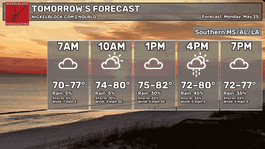
Widespread showers and thunderstorms will develop, die out, and redevelop throughout the day. No single location will be guaranteed to get hit but there will be numerous storms across the area.
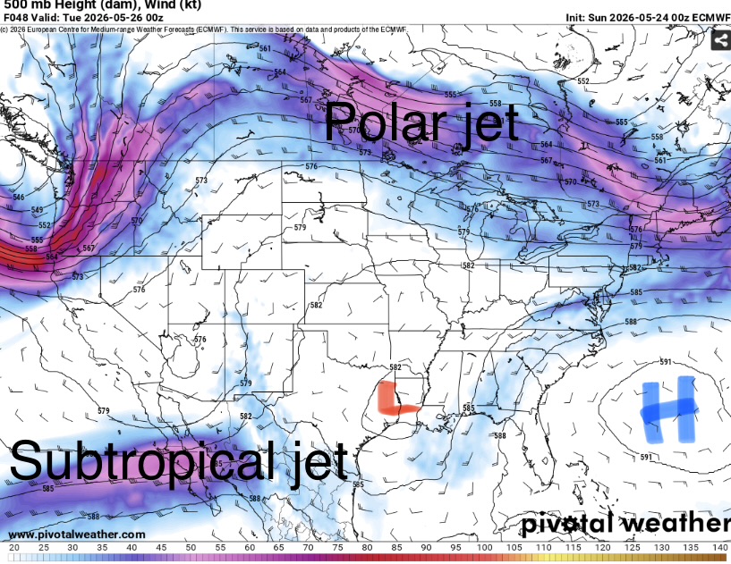
This is due to the position of the jet stream. While the more winds (polar jet) are far to the north, a weak low embedded in the subtropical jet is causing some increased increased lift. This is coupled with southerly winds in the low levels pulling moisture of the gulf.
Highs will be in the low 80s in the areas that can get some sun while areas that stay cloudy may be stuck in the upper 70s.
Winds will be very light and the humidity very high so even if your area is dry it may not be a super pleasant Memorial day to be outside for long.

The Day After Tomorrow
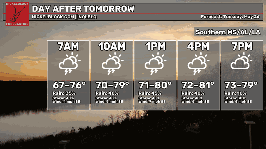
Yet another day of more storms and yucky humidity.
Clouds will build throughout the morning and become thunderstorms by mid-afternoon. Highs will again be in the low 80s with very high humidity.
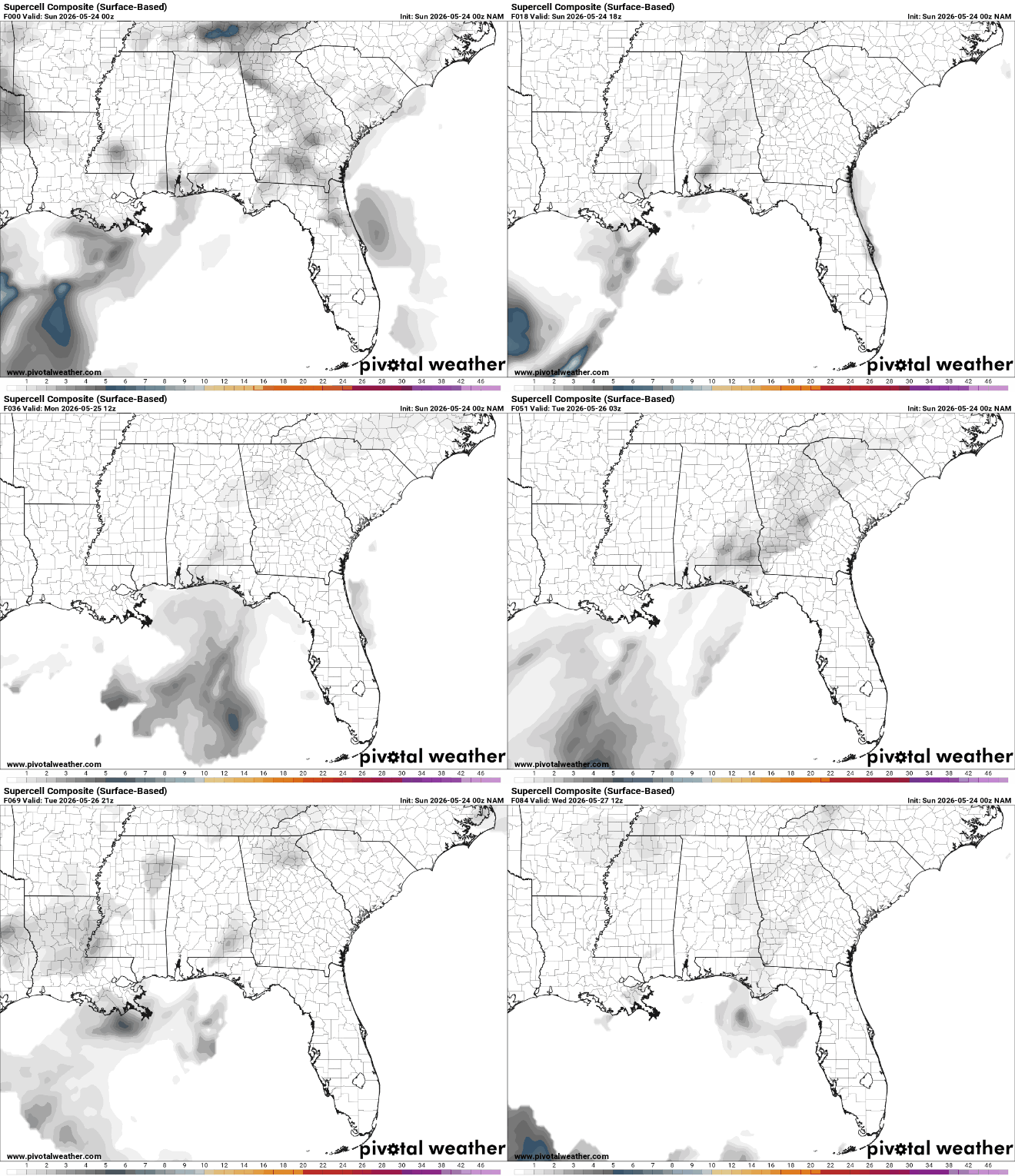
Thankfully, the threat for organized severe weather. The gif above shows a composite parameter that combines ingredients favorable for severe weather. Overall, the general pattern does look to support much besides maybe a strong downdraft or two and maybe (but probably not) a very weak tornado.
The bigger issue will be flooding. If thunderstorms are able to occur in the same place repeatedly, the soils will be unable to absorb any more water and flooding will occur. Be mindful of low water crossings or areas that are known to flood.

Extended Outlook
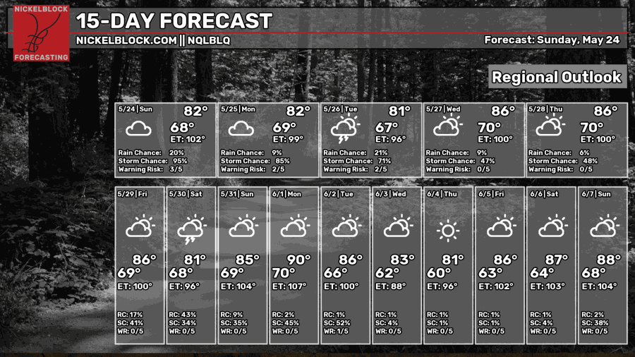
The following few days should be a continuation of the weekend. Widespread slow moving thunderstorms that are fairly weak.
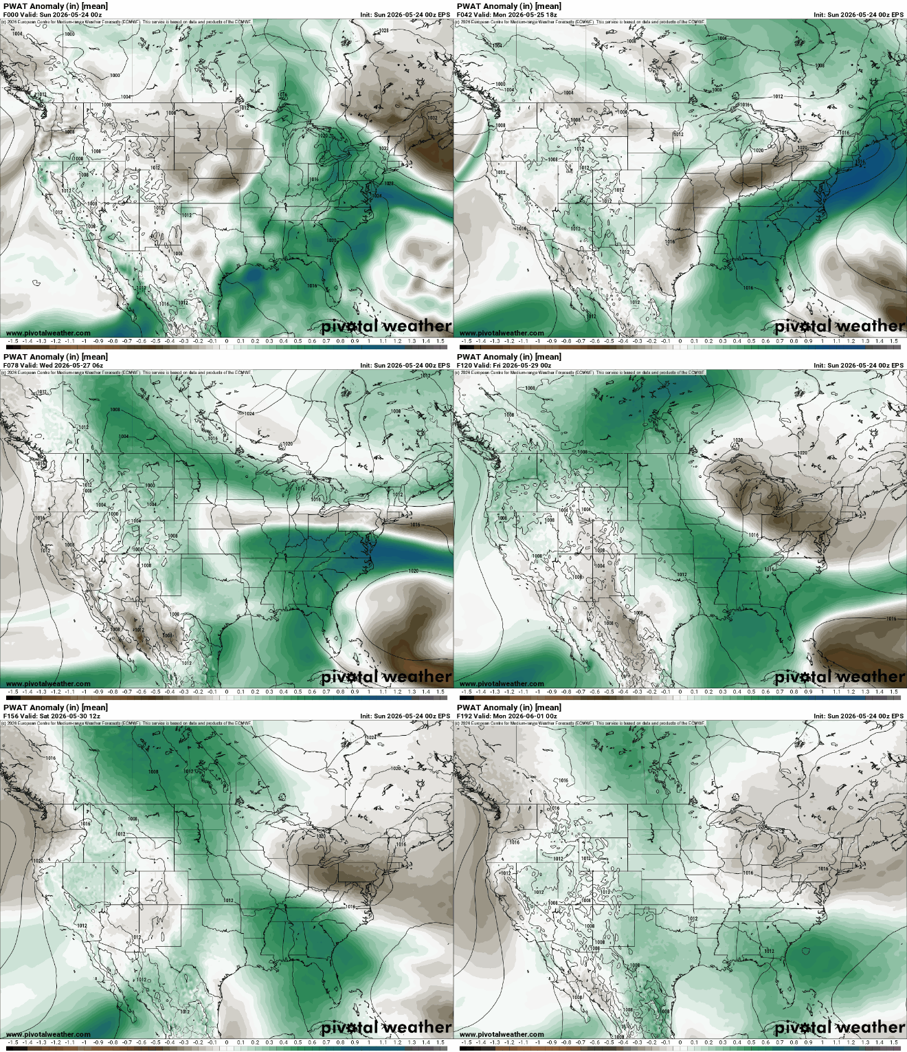
Above average moisture will remain in place in the short term which will provide plenty of fuel for rain and storms. The flooding threat will also increase as rainfall continues across the region. Fortunately, this will definitely improve the drought conditions.
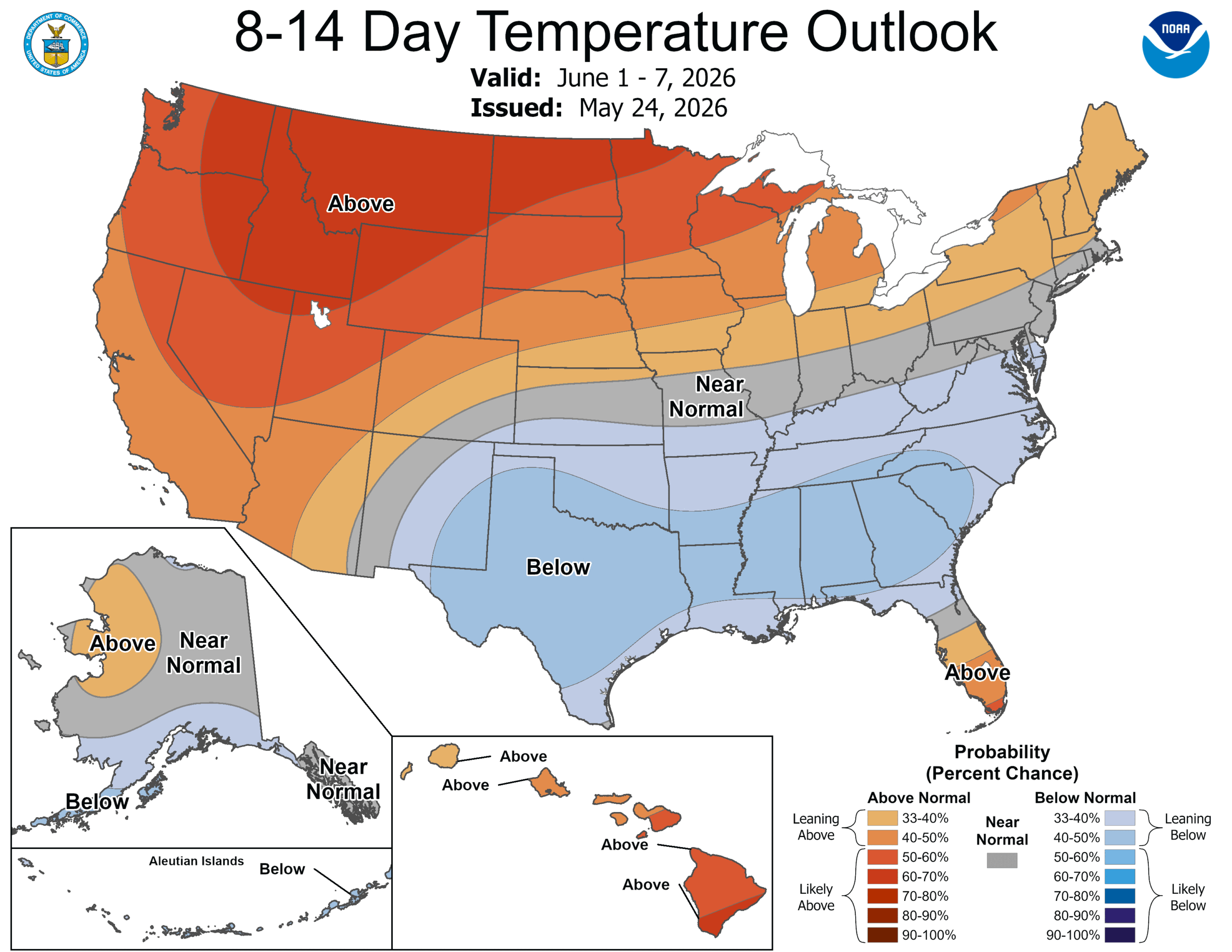
Due to the abundant clouds and precipitation, temperatures may be cooler than average (mainly due to lower daytime highs). There are signs that this pattern may flip around a few days into June but that’s too away to know for certain.
Day-By-Day Forecast
Tonight- Scattered Thunderstorms. Lows in the upper 60s and mostly cloudy. Light winds
Tomorrow- Widespread thunderstorms. Highs in the low 80s with mostly cloudy skies. Light south winds.
Tomorrow night- Thunderstorms likely and mostly cloudy. Humid with lows in the upper 60s.
Tuesday- Mostly cloudy with highs in the lower 80s. Thunderstorms likely and humid.
Tuesday night- Scattered thunderstorms with lows around 70. Mostly cloudy and humid.
Wednesday- Partly sunny with highs in the mid 80s. Scattered afternoon thunderstorms.
Wednesday night- Mostly cloudy with thunderstorms likely. Lows in lower 70s.
Thursday- Highs in the low to mid 80s. Mostly cloudy with widespread thunderstorms.
Thursday night- Mostly cloudy with lows around 70. Scattered thunderstorms.
Friday- Mostly cloudy with highs in the mid 80s. Scattered thunderstorms likely in the afternoon.
Friday night- Mostly cloudy with lows around 70. Scattered thunderstorms.
Saturday – Partly sunny with highs in the mid 80s. A few thunderstorms likely in the afternoon.
Saturday night- Mostly cloudy with highs in the upper 60s. Scattered thunderstorms possible.


