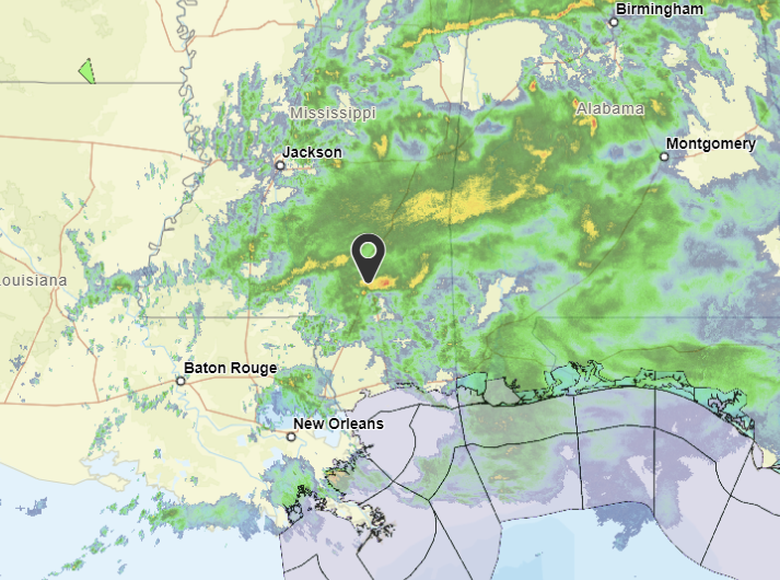
Quite the rainy morning. Thunder and brief heavy rain will be possible.
The reason? Right now, we’re seeing an upper-level weather system moving through western Missouri while at the same time, there’s a high-pressure system sitting over the Bay of Campeche, in the southern Gulf of Mexico and Caribbean Sea.
This setup is causing a lot of moisture to move in from the southwest, leading to scattered to numerous rain showers across the area. The heaviest rain is expected to be focused along the Gulf Coast, where a low-pressure system is developing. Rainfall totals could reach over an inch in some areas. Temperatures will be on the cool side, with highs in the upper 50s to low 60s and lows in the mid-upper 40s. There’s also a chance of dense fog overnight, especially in areas with lots of moisture.
As we head into the weekend, we’ll likely see a general break from the rain, and temperatures will start to warm up again. Highs will reach the low to upper 70s by Sunday, and lows will be in the 50s.
A weather system will move into the Pacific Northwest early next week, bringing more rain chances to our area. This system will interact with a frontal boundary draped across the Great Lakes and Midwest, leading to increased moisture and the potential for heavy rain. Rainfall totals could exceed 2-3 inches in some areas, especially southeast of the Natchez Trace.
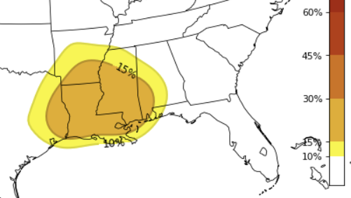
With the setup, there’s also a chance for some stronger storms on Monday and Tuesday. Temperatures will remain warm, with highs in the low to mid 70s and lows in the upper 50s to low 60s.
REGIONAL DAY TO DAY FORECAST
Today: Showers with a chance of thunderstorms in the morning, then showers likely with a slight chance of thunderstorms in the afternoon. Highs in the mid 60s. East winds 10 to 15 mph with gusts up to 25 mph. Chance of rain near 100 percent.
Tonight: Cloudy. A chance of showers with a slight chance of thunderstorms in the evening, then a slight chance of showers after midnight. Patchy fog in the evening, then areas of fog after midnight. Lows in the mid 50s. North winds around 5 mph. Chance of rain 20 percent.
Saturday: Mostly cloudy in the morning, then becoming partly sunny. A slight chance of showers and thunderstorms. Highs in the mid 70s. North winds around 5 mph, becoming east in the afternoon. Chance of rain 20 percent.
Saturday Night: Partly cloudy in the evening, then becoming mostly cloudy. Lows in the upper 50s. Southeast winds around 5 mph.
Sunday: Mostly cloudy in the morning, then partly sunny with a slight chance of showers and thunderstorms in the afternoon. Highs in the upper 70s. Chance of rain 20 percent.
Sunday Night: Mostly cloudy. Lows in the lower 60s.
Monday: Mostly cloudy with a slight chance of thunderstorms. A chance of showers in the morning, then showers likely in the afternoon. Highs in the mid 70s. Chance of rain 30 percent.
Monday Night: Mostly cloudy with a slight chance of thunderstorms. A chance of showers in the evening, then showers likely after midnight. Lows in the lower 60s. Chance of rain 70 percent.
Tuesday: Showers with a slight chance of thunderstorms. Highs in the lower 70s. Temperature falling into the upper 60s in the afternoon. Chance of rain 80 percent.
Tuesday Night: Mostly cloudy. A chance of showers with a slight chance of thunderstorms in the evening, then a chance of showers after midnight. Lows in the upper 50s. Chance of rain 50 percent.
Wednesday: Partly sunny with a chance of showers. A slight chance of thunderstorms in the afternoon. Highs in the upper 70s. Chance of rain 20 percent.
Wednesday Night: Partly cloudy with a slight chance of showers in the evening, then mostly cloudy with a chance of showers after midnight. Lows in the upper 50s. Chance of rain 20 percent.
Thursday: Partly sunny. Highs in the mid 70s.


