We really only have about three (maybe four) more chances to get truly organized severe weather across the area before Spring Severe Weather Season is over. And the atmosphere is already starting to look like “mid-to-late May” which is a good sign that it will be more difficult to get the typical severe weather – tornadoes, hail, damaging wind – going.
First things first: the rain on Wednesday and Thursday.
As a little area of low pressure lifts out of the Gulf, it will spin some showers and storms our direction. Some of the rain may be heavy at times, so brief localized flash flooding will be possible inland. Along the coast, coastal flooding may be a concern, too, with an onshore wind.
Severe weather is not anticipated.
For technical “severe” weather, we have to look out a bit further in time. The first of the next few chances for potentially severe storms show up this weekend. But it isn’t a slam dunk. As it rolls through, it looks like most of the storm activity will be out ahead of the front and be rather cluttered and disorganized.
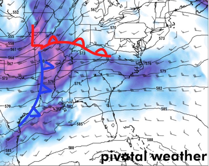
The parent area of low pressure will be up in the north-central Plains which means we will be a long way away from a bulk of the atmospheric torque.
The next chance for storms will be around the 18th of April. And the CIPS Analogs are already picking up on the potential for storms and severe weather (wind and hail) across a wide area.
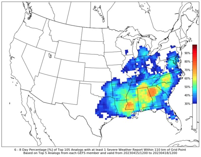
Often, though, when I see things like this I’m less concerned about a “big severe weather outbreak” and more skeptical that CIPS is identifying the true area facing the actual threat for severe weather.
Either way, next Tuesday may be a day to watch.
After that, the following weekend may feature yet another round. Then we start to sneak closer to May when the ability for the atmosphere to produce organized storms and significant severe weather down here becomes a bit more difficult.
NEW STUFF!
I’ve been hard at work trying to develop these new maps and they are coming along reasonably well. They still need some “cleaning up” but I’m happy to say I’ve gotten the ‘basic stuff’ figured out.
Scroll through a handful of parameters! Temperature, dewpoint, wind direction, wind speed, and a few others
AG FORECAST
Here is a look at the Ag Froecast

For a full-size image CLICK HERE
DAY TO DAY FORECAST
Today: Partly sunny. Highs in the mid 70s. Northeast winds 10 to 15 mph.
Tonight: Partly cloudy. Lows in the mid 50s. Northeast winds around 5 mph.
Wednesday: Partly sunny in the morning, then mostly cloudy with a chance of showers in the afternoon. Highs in the mid 70s. East winds 5 to 10 mph with gusts up to 20 mph. Chance of rain 20 percent.
Wednesday Night: Mostly cloudy with showers and storms possible. Severe weather unlikely. Lows in the upper 50s. East winds 5 to 10 mph. Chance of rain 70 percent.
Thursday: Showers likely with a chance of thunderstorms. Highs in the mid 70s. Chance of rain 70 percent.
Thursday Night: Mostly cloudy with lingering showers possible. Lows in the upper 50s. Chance of rain 20 percent.
Friday: Mostly sunny. Highs in the lower 80s.
Friday Night: Partly cloudy. Lows in the lower 60s.
Saturday: Partly sunny with a chance of showers with a slight chance of thunderstorms. Highs in the lower 80s. Chance of rain 40 percent.
Saturday Night: Mostly cloudy. Lows in the mid 60s.
Sunday: Mostly cloudy with a few storms possible Highs in the upper 70s. Chance of rain 30 percent.
Sunday Night: Partly cloudy. Cooler with lows in the lower 50s.
Monday: Sunny. Highs in the mid 70s.


