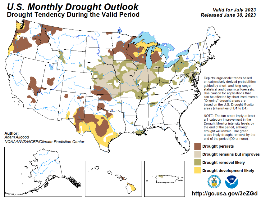
In what should continue to help make dents in the current drought conditions gripping the eastern half of the state, more opportunities for precipitation will exist throughout the rest of the week. Northwesterly flow aloft will more or less stay parked overhead us through the next week or two, giving us generally a broad chance at organized, sustained thunderstorm activity. With various different atmospheric conditions in play, some days may see chances at severe thunderstorms. Aside from all of this, we will still enjoy the relatively average to slightly below average (with the exception of today and tomorrow) temperatures everywhere, except for those in far southern Kansas who may see a few extra days of warmer temperatures.
Short-Term Outlook
Round 1 of showers and thunderstorms look to arrive from a potential MCS originating in central Nebraska and propagating south-southwest through central Kansas by midnight, before exiting the state by 7am. Primary locations most likely to see these thunderstorms will be west of K-99. More specific areas may see thunderstorms during the following times: Concordia – 11pm to 1am, Ellsworth/Salina – 12am to 3am, Hutchinson/Wichita – 2am to 4am and Winfield – 4am to 6am. Those with best odds at seeing these showers and thunderstorms may generally see rainfall totals between a quarter and half an inch, with the strongest of storms potentially dropping up to an inch of rainfall. By the afternoon, temperatures should recover well enough and will see widespread high temperatures in the mid to upper 90s.
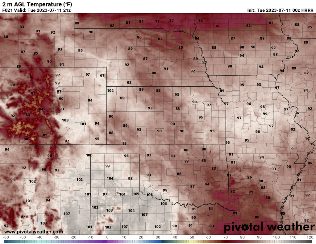
Wednesday will mostly see the hottest temperatures across the state throughout the afternoon, with temperatures in the upper 90s to low 100s common across central and eastern Kansas. By the late afternoon hours (around 3-4pm), a passing shortwave trough will help initiate thunderstorms in southeastern Nebraska/northeastern Kansas. These storms will attain supercell characteristics early before clustering together and marching southeast throughout the evening hours. Moderate to strong vertical wind shear, modest ML CAPE (Mixed-Layer Convective Available Potential Energy, “atmospheric juice”) in the order of ~1500 J/kg, and steep low-level lapse rates (rate temperature changes with height) of 7-8 C/km will help support a large hail and damaging wind threat with these storms. While not anticipated, a tornado cannot be ruled out with the amount of low-level wind shear in place. Timing on these storms for cities and surrounding areas are as follows: Marysville – 5pm to 7pm, Topeka/Lawrence – 6pm to 8pm, and Louisburg – 7pm to 9pm. Further isolated development may occur for areas west of US-75 and east of I-135 between 4pm and 10pm, but confidence is low at this time. Rainfall will generally be more confined to northeast Kansas but may be approaching 1.5 inches with the heaviest of downpours in these storms.
Thursday will see temperatures come down somewhat, with highs in the upper 80s to low 90s. Continued northwest flow aloft may help provide enough lift for the development of scattered showers and thunderstorms throughout central and eastern Kansas from 4pm to 10pm. Rainfall amounts will also be light and specific areas that have the best chance at seeing precipitation are too uncertain to tell at this moment.
Long-Term Outlook
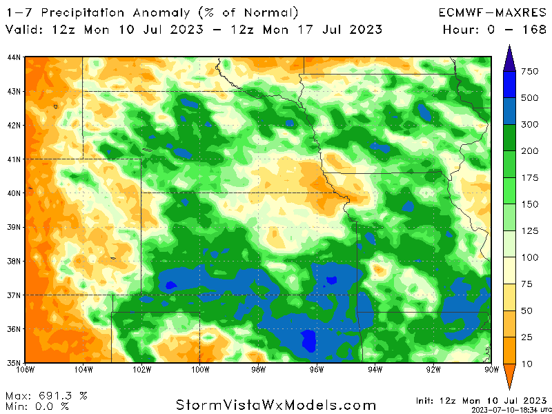
Late week into early next week will continue to see chances for scattered showers and thunderstorms at some point every single day. Total QPF amounts throughout central and eastern Kansas over the next 7 days will be around 1.5-2 inches, or around 125% to 200% of normal, with some locations potentially exceeding that mark. Temperatures will continue to remain right around average throughout the forecast period, staying mostly in the upper 80s to lower 90s. This trend of daily thunderstorm chances and average temperatures perhaps may continue over the next couple weeks, as this upper air regime of high pressure in the west, low pressure in the east, and northwest flow overhead us does not seem to want to budge currently.
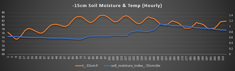
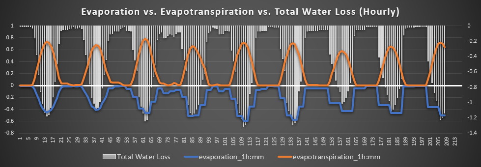
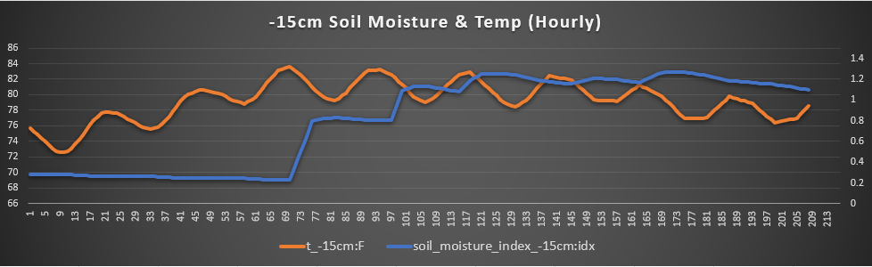
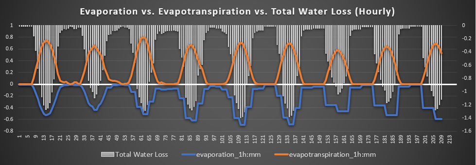
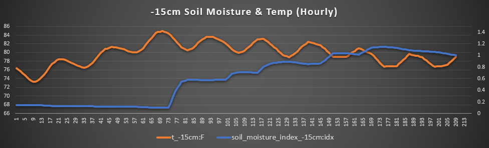
Agriculture Forecast
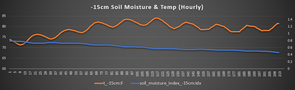
Salina, Ellsworth, and Lindsborg – One of the drier regions in the area, this trend will largely continue over the next week. Temperatures will range between the upper 80s to low/mid 90s, with winds largely being quiet at 5 to 10 mph out of the east. Chances for rainfall will be lesser over here, and as such, we will see gradual drying of the soil at the 15 cm level over the next 7 days. Soil temperatures will remain fairly warm as well, with 15 cm soil temperatures ranging from 78 to 84 degrees. Hopefully these rain chances perform, and even overperform, to help crops out here and keep slowly improving drought conditions.
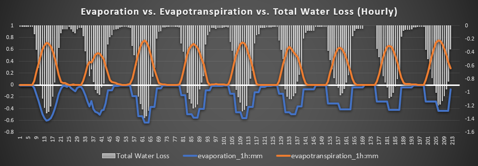
Chanute, Fredonia, and Neodesha – Out here in southeastern Kansas, the soil is fairly saturated down here and will continue to be so over the next week. Starting in the atmosphere, temperatures will fluctuate between the mid 80s to mid 90s over the next 7 days. Winds will largely be out of the south-southwest at 5 to 15 mph. Total water loss throughout the next 7 days do not look to exceed 1.3 mm/hr on any given day. Soil temperatures look to raise into the lower to mid 80s, but will also see continued recharge with the multiple opportunities for showers and thunderstorms throughout the week.

Olathe, Ottawa, and Lawrence – Much needed rainfall will be on the way for this area to help battle the very dry soil moisture that has been around for a while now. Air temperatures will stay in the upper 80s to mid 90s, with the hottest day on Wednesday potentially reaching 100 degrees. Winds will stay fairly light at 5 to 10 mph out of the south. Soil temperatures will stay in the upper 70s to low 80s and should see a noticeable increase in moisture content by mid to late week. Total water loss looks to remain at or below 1.3 mm/hr.
Osage City, Lyndon, and Burlingame – Another area that badly needs rainfall, relief will be on the way over the next 7 days. Firstly, air temperatures will stay between the mid 80s and low 90s, with winds breezy at times at 5 to 15 mph mostly out of the south. 15 cm soil temperatures will peak to around 85 degrees by Thursday before slowly tapering off to the upper 70s and low 80s by the late week/early next week timeframe. Total water loss may be the worst here, with some days reaching a loss rate of 1.4 mm/hr, but hopefully enough rain will fall to mitigate this loss.
Climate/ENSO Update
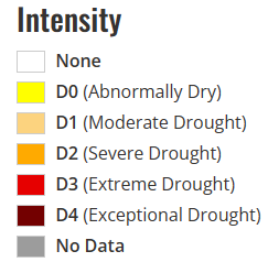
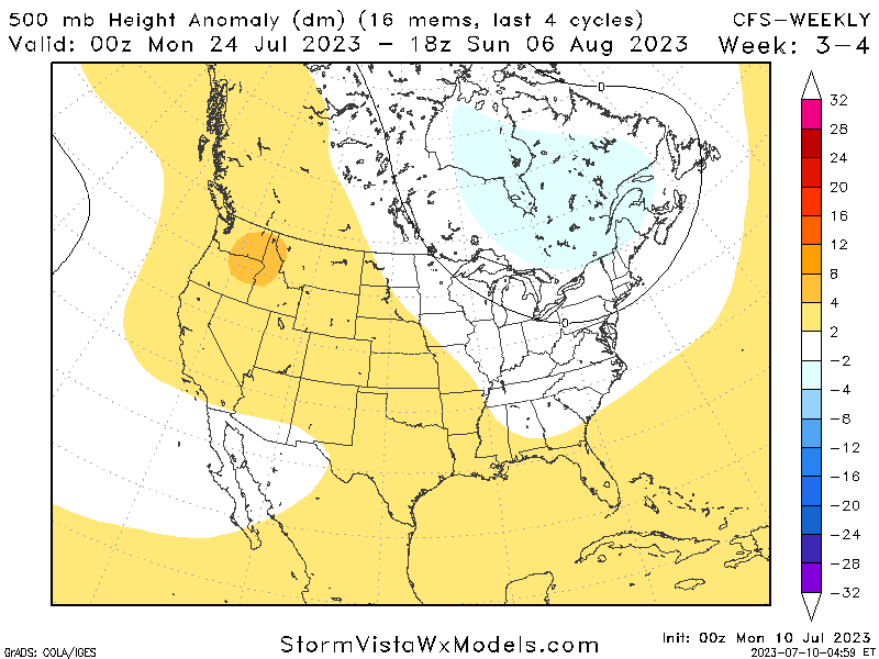
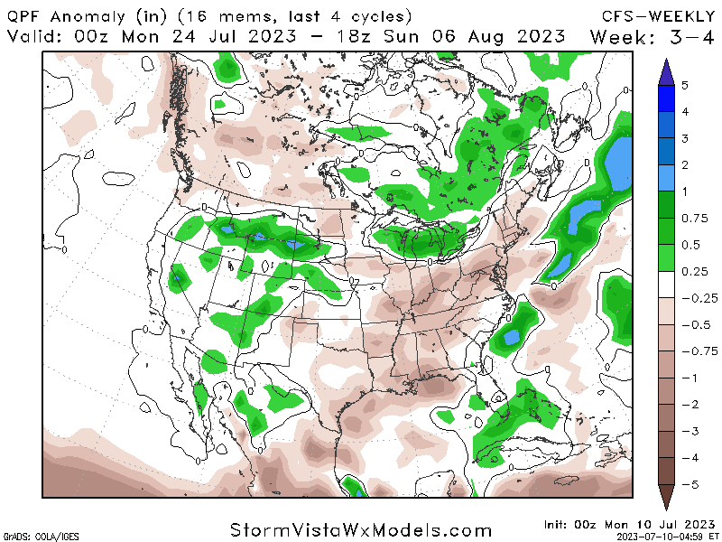
El Nino conditions are firmly in place across the East Pacific and will continue to strengthen throughout the rest of the summer. Climatologically over the next 16-30 days, high pressure will look to keep building out in the western half of the US and eventually make more of its presence felt here in the form of reduced rainfall chances and increased temperatures. Day to day conditions may vary greatly from the mean, but overall, reduced total rainfall and slightly warmer temperatures will be favored here, as is on par for this time of the year.
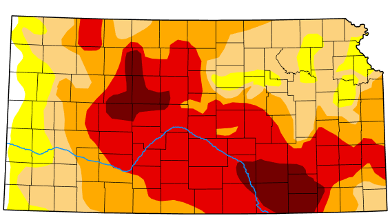
Drought Update
Currently, virtually all of Kansas is in some form of drought condition, with the worst still being found in central and south-central Kansas. Drought improvement in the eastern half of the state is still favored over the rest of the month and some drought removal possible. Temperatures look to remain around average the rest of the month and above-average precipitation is still favored heading into August.