We’ve set for a cold front to move through the area on late Friday and into Saturday morning. Then the front will hang up off the coast and lift back north over the weekend and may leave us with a bit of a soggy go of it here and there as we move through Saturday, Sunday and into next week.
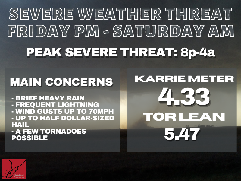
Fir things first: The chance for storms on Friday night and into Saturday morning…
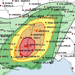
The Storm Prediction Center has issued a Moderate Risk for severe weather back to the NW of the area. That is a “4” on the 1-to-5 scale where “5” is the highest risk for the most significant severe weather.
In our area, we will be in a “2” and a “3” on the same scale.
The main concern right now is for brief heavy rain, lightning, brief wind gusts up to 70mph, hail up to the size of half dollars, and the potential for a few tornadoes.
But not everyone will see all of these things.
WHO SEES WHAT DURING THE STORMS?
EVERYONE — Breezy conditions, brief rain shower, wind gusts up to 35mph
MOST AREAS — Breezy conditions, brief heavy rain, lightning, wind gusts up to 45mph
SOME PEOPLE — Breezy conditions, one extended round of heavy rain, frequent lightning, wind gusts up to 60mph, small hail
FEW SPOTS — Breezy conditions, very heavy rain, brief localized flash flooding, frequent lightning, wind gusts up to 70mph, hail up to the size of quarters, the chance for a tornado (up to EF-3 in strength)
TIMELINE
WEST — 6p through 1a
CENTRAL — 8p through 3a
EAST — 10p through 5a
The timeline has shifted a bit toward the overnight hours Friday and into Saturday morning. But, simultaneously, the highest risk area has shifted northwest of the our area. So, yes, the timeline has moved things into the overnight hours, but the highest risk (but not the only risk) has moved to the northwest.
Once this all moves through, then we are left with hit and miss storms returning by Sunday. These should be generally just ‘regular’ storms and not severe, but I am a bit concerned about flooding and storms with lightning and small hail. Storms will be pretty hit and miss, though, so I don’t know if I would cancel weekend plans yet. Instead, I’d just make sure to have a way to see the radar and get alerts from the NWS.
Like, the NickelBlock Forecasting weather app!

REGIONAL DAY-TO-DAY FORECAST
Today
Patchy fog this morning. Mostly sunny. Highs in the mid 80s. South winds 10 to 15 mph.
Tonight
Partly cloudy in the evening, then becoming mostly cloudy. Patchy fog after midnight. Not as cool with lows in the mid 60s. South winds 5 to 10 mph with gusts up to 20 mph.
Friday
Mostly cloudy with some patchy AM fog. Highs in the mid 80s. South winds 10 to 15 mph with gusts up to 25 mph.
Friday Night
Mostly cloudy with a chance of showers and thunderstorms Some severe. Lows in the upper 60s. South winds 15 to 20 mph with gusts up to 30 mph. Chance of rain 50 percent.
Saturday
Pre-dawn storms possible, then clearing. Highs in the mid 80s. Southwest winds 10 to 15 mph with gusts up to 25 mph. Chance for rain around 40 percent
Saturday Night
Mostly clear. A slight chance of showers after midnight. Lows around 60. Chance of rain 20 percent.
Sunday
Partly sunny with a few storms possible. Highs in the upper 70s. Chance of rain 40 percent.
Sunday Night
Mostly cloudy with a few storms possible. Lows in the mid 60s. Chance of rain 40 percent.
Monday
Mostly cloudy with a few storms possible. Highs in the upper 70s. Chance of rain 40 percent.
Monday Night
Mostly cloudy. Lows in the mid 50s.
Tuesday
Mostly sunny. Highs in the lower 70s.
Tuesday Night
Partly cloudy in the evening, then becoming mostly clear. Lows in the upper 40s.
Wednesday
Sunny. Highs in the lower 70s.


