After a beautiful weekend, we’ll be back into our cycle of possible severe weather come this Wednesday. With it comes a lot of rain, some hail, and some gusty winds.

To start us off, let’s look at the upper-levels. A stout low pressure system over the northern plains is extending much further south and stalling. Another low pressure system from the desert southwest is developing and moving east, however it will remain over the southern US which will affect its behavior.
With the low in the northern plains stalling over eastern Canada, this will cause the southern low to slow down as it reaches Texas and Louisiana. A broad line of storms will develop with plenty of Gulf moisture inflow over Texas, Louisiana, and Arkansas. This will start the first line of storms on Monday which will reach as far as southeastern Louisiana and northeastern Mississippi. Isolated and scattered thunderstorms will be possible across Mississippi on Monday.
Come Tuesday, the line of storms will become more organized with the warm sector developing out of the northwestern Gulf. While this won’t have a big effect of heavy rain on southern Mississippi, areas in north Louisiana, Arkansas, north Mississippi and Tennessee will see quite a bit.
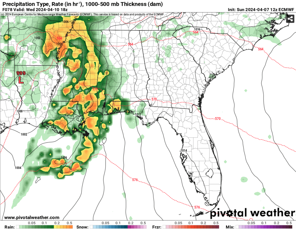
Come Wednesday is when the low begins to organize and move into the southeast. With this, a stout line of storms will develop over Louisiana and Arkansas and make their way east into Mississippi and Alabama. Precipitable water amounts are quite high with this system meaning that rainfall amounts during the day will be at least 1.5 inches and could reach up to 3 inches in some areas of south and central Mississippi and southeastern Louisiana. Areas in northern Mississippi could reach upwards of 5 inches of rain by Thursday.
Other concerns with this storm system would be gusty winds and hail. Hail the size of golf balls will be possible with a slight dry sector in the mid levels helping to develop it. Strong winds will also be possible with plenty of mixing in the atmosphere as the storm passes. The tornado threat looks fairly low, but it doesn’t mean that one won’t pop up during this event. This looks to affect most of the southeast from early Tuesday morning to early Thursday morning as it moves into Alabama. We will keep you updated as the model guidance improves and the Storm Prediction Center is able to hone in on the severe weather threat.
The rest of the week looks to be quite pleasant! Temperatures will be just above average with a few clouds in the sky as we go into the weekend, so expect another good weekend to be outside.
[wpcode id=”41179″]
Regional Day-to-Day Forecast
This Afternoon
Mostly sunny, with a high in the low 80s. South wind around 10 mph.
Tonight
Mostly cloudy, with a low in the low 60s. South southeast wind 5 to 10 mph.
Monday
A 50 percent chance of showers and thunderstorms, mainly in the afternoon. Increasing clouds, with a high near 80. South southeast wind 5 to 10 mph. New rainfall amounts of less than a tenth of an inch, except higher amounts possible in thunderstorms.
Monday Night
A 30 percent chance of showers and thunderstorms, mainly before 1am. Mostly cloudy, with a low in the low 60s. Southeast wind around 10 mph.
Tuesday
A 20 percent chance of showers and thunderstorms. Cloudy, with a high in the low 80s. South southeast wind 10 to 15 mph, with gusts as high as 20 mph.
Tuesday Night
A 40 percent chance of showers and thunderstorms, mainly after midnight. Mostly cloudy, with a low in the mid 60s. Southeast wind 10 to 15 mph, with gusts as high as 25 mph.
Wednesday
Showers and thunderstorms. Some of the storms could be severe. High in the mid 70s. Southeast wind 10 to 15 mph, with gusts as high as 30 mph. Chance of precipitation is 100%.
Wednesday Night
A chance of showers and thunderstorms before midnight, then a slight chance of showers. Some of the storms could be severe. Mostly cloudy, with a low in the upper 50s. South wind 10 to 15 mph becoming west after midnight. Winds could gust as high as 25 mph. Chance of precipitation is 50%.
Thursday
Mostly sunny, with a high in the low 70s. Northwest wind 10 to 15 mph, with gusts as high as 30 mph.
Thursday Night
Clear, with a low in the upper 40s.
Friday
Sunny, with a high in the mid 70s
Friday Night
Mostly clear, with a low in the upper 40s.
Saturday
Sunny, with a high in the low 80s.
[wpcode id=”41149″]


