Summertime patterns are in full swing for the Continental U.S. (CONUS) will high temperatures and plenty of thunderstorms and rain to go around. Currently, we have been seeing rounds of severe weather in the upper-plains wrapping around the ridge into the Mid-Atlantic states. Plenty of thunderstorm activity has been blanketing the Southeast while excessive heat is parked over the Central U.S. Also, monsoonal rain is expected in the Southwest over New Mexico into Colorado.
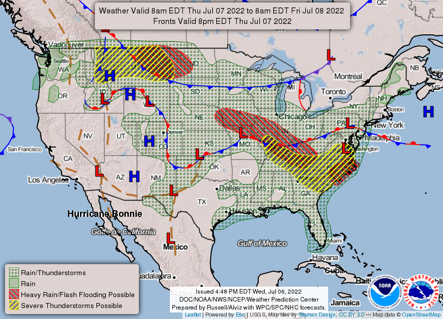
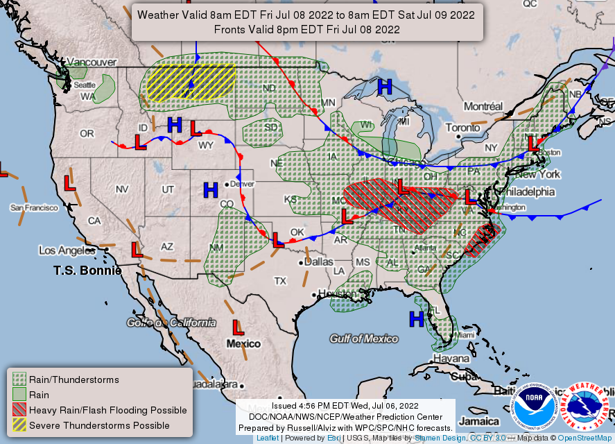
A stationary front over the Ohio Valley into the Plains will remain mostly put the next couple days while a cold front associated with a trough over Eastern Canada will dip past the Great Lakes by Friday. This cold front will bring some drier and cooler temperatures into the Northeast. For Thursday and Friday, the same pattern from the past couple of days will persists before the upper-level high pressure ridge retrogrades back to the West.
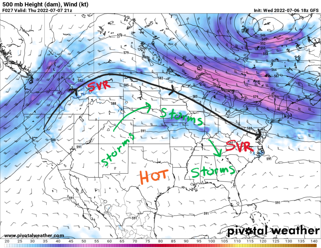
More Severe Storms Expected on the Perimeter of the Ridge
Similar to the past couple of days, severe weather is expected to roll through parts of the country again in the next few days. These systems could take on the form of a mesoscale convective system (MCS) as we saw on Tuesday with the derecho (a type of MCS) that moved through the Dakotas into the Corn Belt. A MCS is a collection of thunderstorms in a cloud system that is around 60+ miles in length and exhibits moist, deep convection. These systems, so-called ridge riders, will ride around the perimeter of the ridge along the sharper pressure gradient.
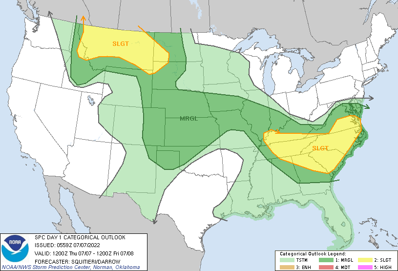
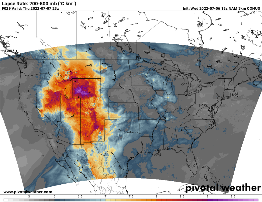
Over Montana, there will exist moderate CAPE values, or available energy in the atmosphere, of around 2000 J/kg along with strong winds aloft. Steep lapse rates above 7.8 C/km could support large hail in some of the stronger storms. Damaging, severe wind gusts 58+mph are a possibility as well in these storms. Tornado risk will be minimal, but a thunderstorm with a rotating updraft to produce a tornado cannot be ruled out.
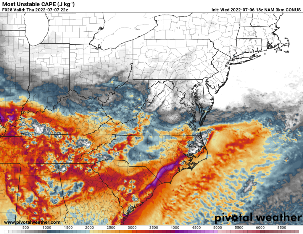
Over Kentucky, Tennessee, and the Carolinas, weaker flow aloft will be present, but higher CAPE values of around 3000 J/Kg will help storms get going along with the moist airmass seeing dewpoint values in the 70s. Damaging wind gusts will be the main threat with the stringer storms. Storms will be scattered in nature with any cell becoming severe.
Over the high plains exists a moderate risk for severe weather as some model guidance suggest storms using the energy from convection in the morning. Plenty of daytime heating will exists along with a very moist airmass to support a good amount of instability. Severe wind gusts are possible along with a brief tornado.
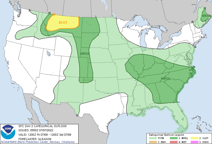
Friday will see a similar set-up again as severe storms will work their way up and around the ridge. Plenty of instability will be present again in the Northern Rockies into Montana and High Plains for storms to initiate with daytime heating. Severe wind gusts and large hail will the most prevalent threats. In the Ohio Valley and Coastal Southeastern states, that persistent moist air mass coupled with string daytime heating will aid in sufficient instability for scattered severe storms. Strong to severe wind gusts should be the main concern.
Excessive Heat Continues in the Central U.S.
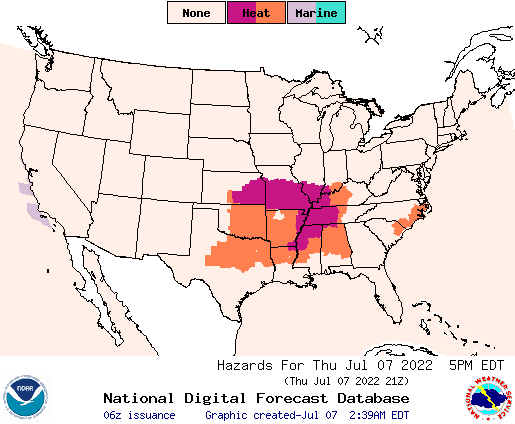
The upper-level high pressure ridge is over the Central U.S. bringing very high temperatures upwards of 100F to some parts. Highs for Thursday in the Southern Plains and Texas will range between 100F and 105F. Sufficient moisture will be present for the heat indices to reach 110F in some places. For this reason, heat advisories and warnings will be in place for these areas as well as the Mississippi Valley. With a low pressure system/trough over Eastern Canada, temperatures will be cooler in the upper 70s for the high in the Northeast.
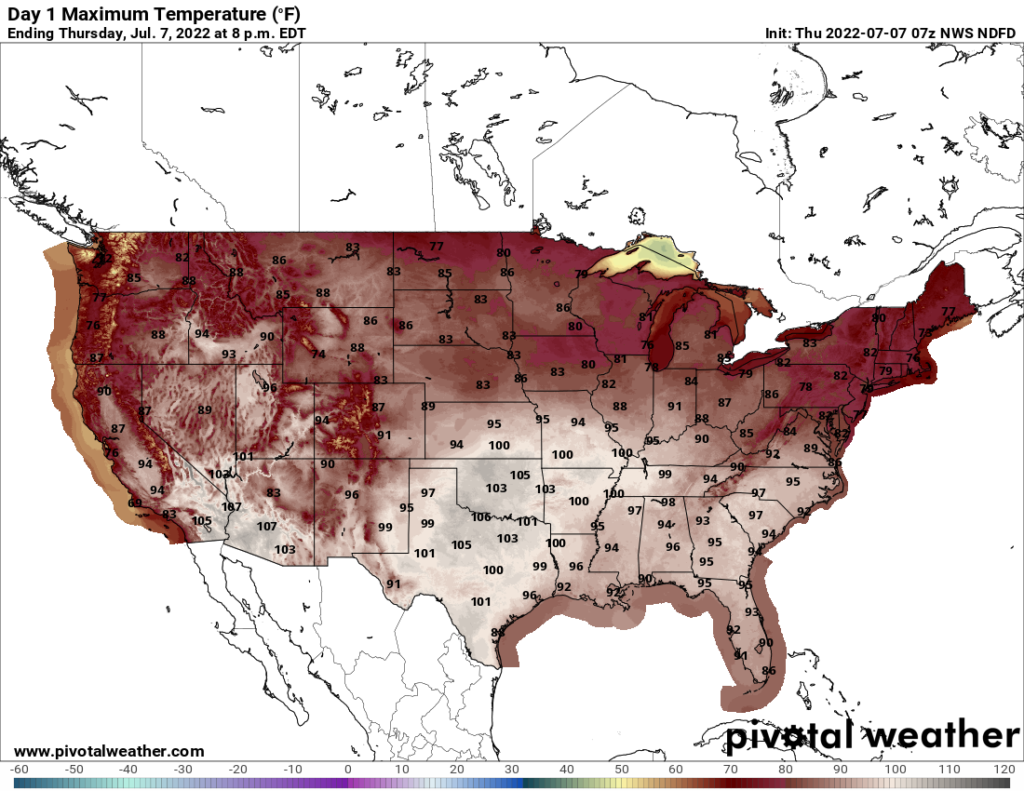
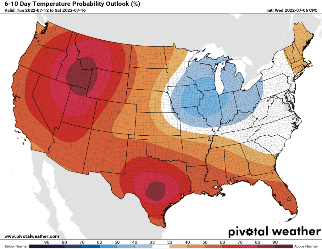
As the week moves ahead, the ridge will back up towards the West and strengthen bringing warmer temperatures westward. These above average temperatures will persist through the next week as well. By next Monday, the Southern Plains and the SE California SW Arizona region could see heat indices up to 110F. Overnight lows will also bring no relief either as they will be in the upper 70s/lower 80s.
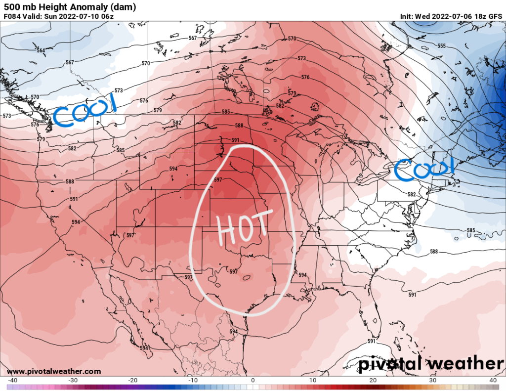
For the next week, the west will warm up with above average temperatures while the Great Lakes and Ohio Valley region will get some relief with cooler temperatures.
Rain and Thunderstorms for the Southwest
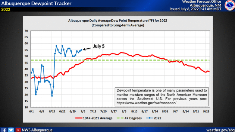
Monsoon season has kicked off for this year in the Southwest region. Into the weekend, showers and storms will roll through New Mexico. Upper-level steering is not particularly strong; therefore, these storms could be slow movers. This presents the risk of locally heavy rainfall and even flash flooding in areas that have seen burn scars from wildfire. This area is seeing an above average moisture content in the atmosphere with the recent moisture surge in the Southwest.