There is still a chance for showers and storms this afternoon with the potential for some severe weather. The Storm Prediction Center didn’t make many changes overnight. And as of this writing (about 430am) the Risk areas are in roughly the same spots.
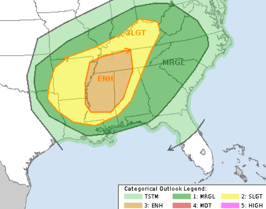
It looks like the only change was to slide the Enhanced area slightly north and cut off some of the edges.


It also looks like they shaved a bit from the hatched tornado area where the SPC is forecasting the best chance to see a tornado that is stronger than EF-2.
Down across our neck of the woods, the model guidance is still in a bit of disagreement with how much instability we get at the surface, and thus still at odds when it comes to outcome. Looking across three of the (roughly) seven available models, they all show different outcomes.


The NAM computer weather model keeps everything across northern Mississippi, Alabama and into Tennessee. The HRW shows a few stronger storms across southern Mississippi and central Alabama. As well as another cluster up in Tennessee. While the HRRR model shows a swatch of multiple stronger storms across much of the region.
I would argue that, given the maps, the highest risk for tornadoes is probably across northern Mississippi, Alabama and Tennessee. With a second area of higher, but not as high, concern along I-20 in Mississippi and Alabama.
The Usual Suspects, I suppose.
But I really do think that for the most part, the Southern MS/AL/LA region will be more likely to see rain and wind than tornadoes. That is why the potentials still hold.

Timeline & Threats
Here is another look at the timeline and threats. This may shift slightly later this morning, but this should be pretty locked in by this point. This timeline is for everyone. I tried to break it out into sections, too, as I’m unlikely going to be able to do a county-by-county breakdown.
6a-10a — Instability showers will be widespread as storms begin to develop toward 10a across parts of southeast Louisiana. Severe weather is less likely during this time period, but not impossible. Main concerns with storms during this time period will be…
– Brief heavy rain
– Lightning
– Gusty wind
10a-2p — Showers and storms, some severe, move across southeastern Louisiana, and southern Mississippi. Main threats with storms during this time will be…
– Very heavy rain
– Brief localized flash flooding
– Frequent lightning
– Wind gusts up to 70mph
– Hail up to the size of quarters
– Tornadoes (up to EF-3 in strength)
2p-6p — Storms ending for Louisiana and parts of southern Mississippi while eastern counties of southern Mississippi and southwest Alabama still deal with storms. Some severe. Main threats with storms during this time will be…
– Very heavy rain
– Localized flash flooding
– Frequent lightning
– Wind gusts up to 70mph
– Hail up to the size of quarters
– Tornadoes (up to EF-3 in strength)
6p-10p — Storms moving out of the area. Some lingering storms across parts of Alabama. Main concerns with storms during this time period will be…
– Heavy rain
– Frequent lightning
– Gusty wind
– Small hail
It still looks like 0.5″ to 2.0″ of rain is the best best across the region in terms of rainfall totals, but I’d bet that a few spots will have a chance to see up to 4″ of rain where some of stronger storms end up moving.
The Karrie Meter is down about 0.15 this morning. And the “TOR POTENTIAL” number you see below is a subset of the Karrie Meter number. In general, if that number is higher than the Karrie Meter it means that tornadoes become more likely if it is lower it means tornadoes are less likely.

It looks like for the Southern MS/AL/LA region this type of setup is less likely to produce tornadoes. That said, “less likely” doesn’t mean “impossible” or even “unlikely” it just means that there are more hurdles in the way for Mother Nature to produce a tornado than in other situations.
Day to Day Forecast
Today
Mostly cloudy with a chance for storms. Some storms may be severe. Windy. Highs in the mid 70s. South winds 15 to 20 mph increasing to 20 to 25 mph in the afternoon. Gusts up to 30 mph increasing to 40 mph in the afternoon. The chance of rain around 100-percent.
Tonight
Mostly cloudy with storms ending. Breezy. Much cooler. Lows in the lower 40s. West winds 10 to 20 mph becoming northwest 10 to 15 mph after midnight. The chance of rain around 40-percent.
Friday
Clearing skies. Cooler. Highs in the mid 50s. North winds 5 to 10 mph.
Friday Night
Partly cloudy with some frost overnight. Chilly. Lows around 30.
Saturday
Morning frost possible. Sunny. Highs in the lower 60s.
Saturday Night
Partly cloudy. Lows in the mid 30s.
Sunday
Patchy morning frost possible. Partly cloudy. Highs in the upper 60s.
Sunday Night
Mostly cloudy. Warmer. Lows in the lower 50s.
Washingtons Birthday
Mostly cloudy with a chance for showers and storms. Highs in the mid 70s. The chance of rain 40-percent.
Monday Night
Cloudy with a few showers possible. Warmer. Lows in the lower 60s. The chance of rain 30-percent.
Tuesday
Mostly cloudy with chance of showers and thunderstorms in the afternoon. Highs around 80. The chance of rain 40-percent.
Tuesday Night
Partly cloudy. Lows in the lower 60s.
Wednesday
Mostly cloudy with another round of showers and storms possible. Highs in the upper 70s. The chance of rain 40-percent.


Nick thank you so very much for your thorough forecast. I always check your blogs for the latest accurate info. Love ya
Nick is the most honest, reliable and dependable meteorologist around! On a side note he’s an awesome person as well, very approachable and kind.
I appreciate the kind words. I try my best to be as straightforward as possible!