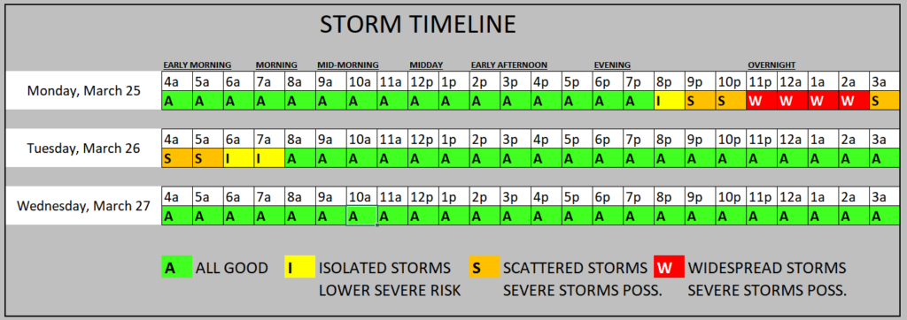
We have another shot for storms as we head through the overnight hours tonight. The general timeline is between 10p and 6a. But I tend to think that may be skewed a bit toward later into the overnight hours than earlier.
Here is a brief breakdown of what to expect:
EVERYONE — Brief heavy rain, some lightning, wind gusts up to 45mph
MOST FOLKS — A few rounds of brief heavy rain, brief localized flash flooding, lightning, wind gusts up to 50mph
SOME SPOTS — A few rounds of extended heavy rain, brief flash flooding, a lot of lightning, wind gusts up to 60mph, small hail
FEW PLACES — A few rounds of extended heavy rain, brief flash flooding, a lot of lightning, wind gusts up to 65mph, ping-pong ball sized hail
VERY SELECT LOCATIONS — A few rounds of extended heavy rain, brief flash flooding, a lot of lightning, wind gusts up to 70mph, ping-pong ball sized hail and a tornado
That is to say that not everyone will see the worst of the weather and not everyone will see a severe storm. But a few spots will, so it is important to prepare for the worst, while hoping for the best.
The Storm Prediction Center has parts of our area under an Enhanced Risk for severe weather. That is a “3” on the 1-to-5 scale where a “5” is the highest risk for the most significant severe weather. Other parts of the area are under a Slight Risk, which is a “2” on the same scale.
The Karrie Meter is at a 4.37 which is a bit lower than the SPC risk would suggest But the “TOR LEAN” which is a measurement of “how primed is the atmosphere going to be to produce tornadoes” is at an 8.16. The scale for that is relative and is measured against the Karrie Meter. So seeing it as nearly twice as much at the Karrie Meter is a good indicator that tornadoes are possible.

I think there will also be a brief window where strong tornadoes will be possible, too. The threat for stronger tornadoes is most likely between 9p and 1a across the area.
The general timeline is below. But keep in mind we are talking about a developing line of storms, so the farther west you live the earlier the storms will be near you and the farther east you live the longer it will take for storms to arrive.
I will try to have a County-by-County forecast posted later today.
REGIONAL DAY-TO-DAY FORECAST
Today: Mostly cloudy. A slight chance of showers this morning, then a chance of showers this afternoon. Windy with highs in the mid 70s. Southeast winds 20 to 30 mph with gusts up to 45 mph. Chance of rain 30 percent.
Tonight: Cloudy. A chance of showers with a slight chance of thunderstorms in the evening, then showers with a chance of thunderstorms after midnight. Windy with lows in the lower 60s. South winds 20 to 30 mph with gusts up to 45 mph. Chance of rain 90 percent.
Tuesday: Mostly cloudy with a chance of showers with a slight chance of thunderstorms in the morning, then mostly sunny with a slight chance of showers in the afternoon. Highs around 80. Southwest winds 15 to 20 mph with gusts up to 30 mph, becoming northwest 5 to 10 mph in the afternoon. Chance of rain 50 percent.
Tuesday Night: Mostly clear. Cooler with lows around 50. Northeast winds 5 to 10 mph, becoming north after midnight.
Wednesday: Sunny. Highs in the mid 70s. North winds 5 to 10 mph.
Wednesday Night: Partly cloudy in the evening, then becoming mostly clear. Lows in the upper 40s.
Thursday: Sunny. Highs in the lower 70s.
Thursday Night: Clear. Lows in the lower 40s.
Friday: Sunny. Highs in the mid 70s.
Friday Night: Mostly clear. Lows in the mid 40s.
Saturday: Mostly sunny. Highs in the upper 70s.
Saturday Night: Mostly clear in the evening, then becoming partly cloudy. Lows in the mid 50s.
Sunday: Mostly sunny. Highs in the lower 80s.


