With the weather getting more warm and humid the next few days, we’re getting set up for some strong winds and possible tornadoes from Monday into Tuesday. Afterwards, we’ll have some beautiful Spring weather to close out the week!
As I mentioned yesterday, a tight gradient at the surface from a low-level jet will allow for strong southeasterly winds to gust up the Gulf coast and further inland. Sustained winds of 10-15mph and wind gusts around 40mph will be possible throughout the day Monday.
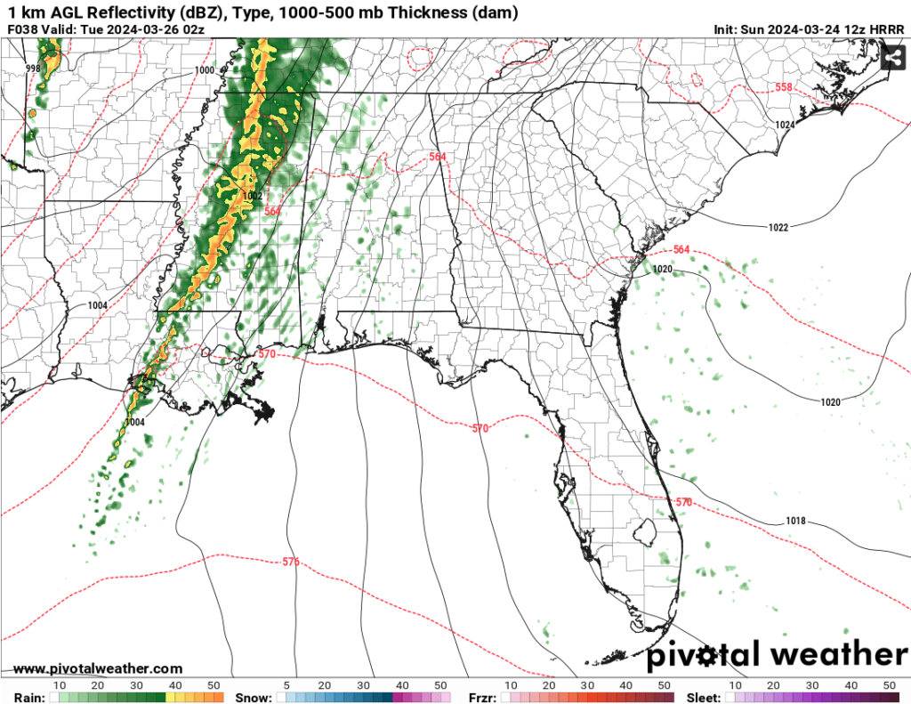
Towards the afternoon, our main line of storms will exit due east from east Texas to Louisiana and Mississippi. The SPC has placed the highest risk of severe weather towards the Louisiana/Mississippi Delta region and as far east as Jackson. A 10% risk of tornadoes and 30% risk of high winds are possible with the incoming line. Strong winds up to 70mph are possible and tornadoes will likely be in the line of storms instead of discrete cells ahead of it. Although the strongest looks to be around the Delta region, areas of central and southeast Mississippi will likely see the same conditions. As the line exits, it will begin to deteriorate by the time it reaches Alabama, but will still bring a slight chance of severe weather as it moves eastward.


Due to the strength of the low and the high pressure right behind it, we’ll have a few windy days after the front has passed. Overall, temperatures will be seasonable around the 70s during the day and into the mid 40s by night. A strong high pressure will even keep the rain further north and bring us a few sunny days into the weekend. Overall, not a bad way to end the week and into the weekend.
[wpcode id=”41179″]
Regional Day-to-Day Forecast
This Afternoon – Mostly cloudy, with a high in the low 70s. South southeast wind around 10 mph.
Tonight – Mostly cloudy, with a low in the mid 50s. Southeast wind around 10 mph, with gusts as high as 25 mph.
Monday – A 30 percent chance of showers and thunderstorms in the mid-afternoon. Mostly cloudy, with a high near 74. Windy, with a southeast wind 15 to 25 mph, with gusts as high as 45 mph.
Monday Night – A chance of showers and thunderstorms, then showers and possibly a thunderstorm after sunset. Some of the storms could be severe. Low in the low 60s. South southeast wind 15 to 20 mph decreasing to 10 to 15 mph after midnight. Winds could gust as high as 45 mph. Chance of precipitation is 90%. New rainfall amounts between three quarters and one inch possible.
Tuesday – A chance of showers and thunderstorms until the early afternoon. Some of the storms could be severe. Partly sunny, with a high in the upper 70s. Southwest wind around 5 mph. Chance of precipitation is 50%. New rainfall amounts between a quarter and half of an inch possible.
Tuesday Night – Mostly clear, with a low in the upper 40s. North northwest wind around 5 mph.
Wednesday – Sunny, with a high in the low 70s. North wind 5 to 10 mph, with gusts as high as 20 mph.
Wednesday Night – Mostly clear, with a low in the mid 40s. North wind 5 to 10 mph, with gusts as high as 20 mph.
Thursday – Sunny, with a high in the upper 60s to low 70s. North wind around 10 mph, with gusts as high as 20 mph.
Thursday Night – Clear, with a low around 40.
Friday – Sunny, with a high in the mid 70s.
Friday Night – Mostly clear, with a low in the mid 40s.
Saturday – Sunny, with a high in the upper 70s.
[wpcode id=”41149″]


