After our brief stint with the rain yesterday, a cold front is passing through today to bring in a couple of days worth of beautiful weather to the Deep South. Temperatures will roll back into the upper 60s/lower 70s and lows jumping from the 40s to 50s to close out the weekend. Our main concern will not only be the severe weather coming overnight on Monday into Tuesday, but also the high wind gusts associated with the incoming front during the day on Monday.

As the high pressure system moves towards the Atlantic coast, we’ll see winds shift from north to east on Sunday, and eventually to the southeast on Monday. Since the cold front in Texas is very close behind the high pressure system, a fairly strong gradient is present (notice how many isobar lines we have over Louisiana to Alabama). This low pressure system is fairly deep, around 988 mb, contrasting from the 1022 mb high to the east, creating a gradient which causes instability and will cause some strong winds to form over most of the deep south, namely Louisiana and Mississippi. With sustained winds of 10-15 mph during the day and mixing throughout from the sun, wind gusts will be prevalent reaching up to 40 miles per hour. Yes, you heard me right. The storm hasn’t even arrived yet and we’re already getting some winds that’ll blow stuff over.
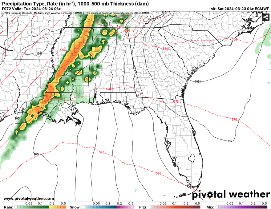

Okay, time for the severe forecast. Areas in northern Mississippi are looking at more of a flash flooding threat, whereas south will see more of the severe weather, but these both won’t be completely mutually exclusive. Looking at both models, this looks to be mostly a squall line system with the severe weather forming in the main line of storms. There may be a few discrete cells ahead of the storm, but this system looks to be plowing through with just the main line. Our main concern will be strong straightline winds, lightning, flash flooding, and tornadoes. Looking at the Skew-T above, from the surface to the atmosphere, there is enough backing in the winds (counter-clockwise up the column) and wind shear to help with both straightline winds and tornadic development. The Storm Prediction Center may increase the risk in the next day or so if all this comes to fruition. In the development of the occluding front, we’ll see a sharp spike in dewpoints to the mid and upper 60s with plenty of south winds and Gulf moisture to support this system. Be on the alert Monday night into Tuesday morning for any warnings that may occur.
The line should move out by mid-Tuesday morning and we’ll see a shift in conditions as the front exits due east. Clouds will clear out and we’ll have some windy but more pleasant weather as it dries up for the next few days.
[wpcode id=”41179″]
Regional Day-to-Day Forecast
Today – Partly sunny, then gradually becoming sunny, with a high in the low 70s. North wind around 15 mph, with gusts as high as 30 mph.
Tonight – Clear, with a low in the low 40s. North wind 5 to 10 mph, with gusts as high as 20 mph.
Sunday – Increasing clouds, with a high in the low 70s. Northeast wind 5 to 10 mph becoming south southeast in the afternoon.
Sunday Night – Mostly cloudy, with a low in the mid 50s. Southeast wind 5 to 10 mph, with gusts as high as 20 mph.
Monday – Mostly cloudy, with a high in the low 70s. Southeast wind 10 to 15 mph, with gusts as high as 40 mph.
Monday Night – A chance of showers and thunderstorms, then showers and possibly a thunderstorm after 1am. Some of the storms could be severe. Low around 60. Southeast wind around 15 mph, with gusts as high as 45 mph. Chance of precipitation is 80%. New rainfall amounts between three quarters and one inch possible.
Tuesday – Showers likely and possibly a thunderstorm before sunrise, then showers and thunderstorms possible until noon. Some of the storms could be severe. Partly sunny, with a high in the mid 70s. South wind 5 to 15 mph becoming north northwest in the afternoon. Winds could gust as high as 30 mph. Chance of precipitation is 70%.
Tuesday Night – Mostly clear, with a low around 49. North wind 5 to 10 mph.
Wednesday – Mostly sunny, with a high in the low 70s. North wind 5 to 10 mph, with gusts as high as 20 mph.
Wednesday Night – Partly cloudy, with a low in the mid 40s.
Thursday – Sunny, with a high near 70.
Thursday Night – Clear, with a low in the low 40s.
Friday – Sunny, with a high in the mid 70s.
[wpcode id=”41149″]


Thanks, Nick