Doing some quick estimates, using NQLBOT our AI weather helper, on a timeline for next week’s storm and the potential outcomes, I wanted to post a quick county-by-county outlook for southern Mississippi.
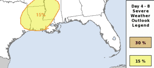
The Storm Prediction Center has maintained the Slight Risk over parts of the area. That is the “@” ont he 1-to-5 scale where “5” is the highest risk for the most significant severe weather. And the model guidance continues to support the risk for some severe weather, too.
The model guidance shows a Karrie Meter for the area around a 4.10 this morning with a TOR LEAN of 3.89. That means a severe even with a barely-lower-than-normal risk for tornadoes. It also converts back to a 2.05 on the SPC scale, which is a Slight Risk. So, everyone is in agreement.
A bit like I mentioned previously, if you assume the global model guidance is undercutting certain parameters that they historically do, I could make an argument for a Karrie Meter value as high as a 5.43 today (as an aside, this is one project I have NQLBOT working on solving) with a TOR LEAN of 7.42. That means a higher-than-normal risk for tornadoes.
So, as you can tell, we still have a lot to shake out.
But I wanted to take some time to give everyone a bit of a “base case” (a place to start) county-by-county outlook for Monday night and into Tuesday morning. This is more of an “outlook” rather than a “forecast” because we still have a good number of moving pieces, but I think as a “base case” it will give everyone an early heads up as to what we expect and generally when to expect it.
Currently, this is only for southern Mississippi but as we get closer I will expand it to cover a few more counties and parishes in SE Louisiana and more of Mississippi, as well as a few in Lower Alabama. That said, if you are in Alabama, I would highly recommend you find Spinks Megginson on social media and follow him for more detailed info and specifics for your area.
I-20 CORRIDOR
Forecast for Simpson County:
NQLBOT-aided Forecast
8p — 12a – As things get started, a few isolated storms are possible. A few may be severe. The main concerns are brief heavy rain, some lightning, gusty wind, small hail. Rainfall totals up to 1 inch possible.
1a — 5a – There is a chance for showers and storms. Some severe. the main concerns are heavy rain, frequent lightning, wind gusts up to 70mph, ping pong ball-sized hail, and a few tornadoes (up to EF2 in strength). Rainfall totals are estimated to be around 1-3 inches.
6a — 10a – All Clear! Though, there is a chance for some lingering brief heavy rain, some lightning, gusty wind, small hail. Rainfall totals up to 1 inch possible.
How it will impact you:
- Roads may be briefly impassable due to short-term flash flooding
- With a lot of lightning expected, make sure to be inside
- Trees may be knocked down, and scattered power outages are likely
- Hail damage is possible, park vehicles under cover if possible
- A Tornado Watch is possible
- Wind-driven hail is possible which could damaging siding, go through windows, and dent cars.
Best to be where you want to be by 11p
Forecast for Smith County:
NQLBOT-aided Forecast
9p — 1a – As things get started, a few isolated storms are possible. A few may be severe. The main concerns are brief heavy rain, some lightning, gusty wind, small hail. Rainfall totals up to 1 inch possible.
2a — 6a – There is a chance for showers and storms. Some severe. the main concerns are heavy rain, frequent lightning, wind gusts up to 70mph, ping pong ball-sized hail, and a few tornadoes (up to EF2 in strength). Rainfall totals are estimated to be around 1-3 inches.
7a — 11a – All Clear! Though, there is a chance for some lingering brief heavy rain, some lightning, gusty wind, small hail. Rainfall totals up to 1 inch possible.
How it will impact you:
- Roads may be briefly impassable due to short-term flash flooding
- With a lot of lightning expected, make sure to be inside
- Trees may be knocked down, and scattered power outages are likely
- Hail damage is possible, park vehicles under cover if possible
- A Tornado Watch is possible
- Wind-driven hail is possible which could damaging siding, go through windows, and dent cars.
Best to be where you want to be by 12a
Forecast for Jasper County:
NQLBOT-aided Forecast
10p — 2a – As things get started, a few isolated storms are possible. A few may be severe. The main concerns are brief heavy rain, some lightning, gusty wind, small hail. Rainfall totals up to 1 inch possible.
3a — 7a – There is a chance for showers and storms. Some severe. the main concerns are heavy rain, frequent lightning, wind gusts up to 70mph, ping pong ball-sized hail, and a few tornadoes (up to EF2 in strength). Rainfall totals are estimated to be around 1-3 inches.
8a — 12a – All Clear! Though, there is a chance for some lingering brief heavy rain, some lightning, gusty wind, small hail. Rainfall totals up to 1 inch possible.
How it will impact you:
- Roads may be briefly impassable due to short-term flash flooding
- With a lot of lightning expected, make sure to be inside
- Trees may be knocked down, and scattered power outages are likely
- Hail damage is possible, park vehicles under cover if possible
- A Tornado Watch is possible
- Wind-driven hail is possible which could damaging siding, go through windows, and dent cars.
Best to be where you want to be by 1a
Forecast for Clarke County:
NQLBOT-aided Forecast
11p — 3a – As things get started, a few isolated storms are possible. A few may be severe. The main concerns are brief heavy rain, some lightning, gusty wind, small hail. Rainfall totals up to 1 inch possible.
4a — 8a – There is a chance for showers and storms. Some severe. the main concerns are heavy rain, frequent lightning, wind gusts up to 70mph, ping pong ball-sized hail, and a few tornadoes (up to EF2 in strength). Rainfall totals are estimated to be around 1-3 inches.
9a — 1p – All Clear! Though, there is a chance for some lingering brief heavy rain, some lightning, gusty wind, small hail. Rainfall totals up to 1 inch possible.
How it will impact you:
- Roads may be briefly impassable due to short-term flash flooding
- With a lot of lightning expected, make sure to be inside
- Trees may be knocked down, and scattered power outages are likely
- Hail damage is possible, park vehicles under cover if possible
- A Tornado Watch is possible
- Wind-driven hail is possible which could damaging siding, go through windows, and dent cars.
Best to be where you want to be by 2a
HWY 84 CORRIDOR
Forecast for Lawrence County:
NQLBOT-aided Forecast
8p — 12a – As things get started, a few isolated storms are possible. A few may be severe. The main concerns are brief heavy rain, some lightning, gusty wind, small hail. Rainfall totals up to 1 inch possible.
1a — 5a – There is a chance for showers and storms. Some severe. the main concerns are heavy rain, frequent lightning, wind gusts up to 70mph, ping pong ball-sized hail, and a few tornadoes (up to EF2 in strength). Rainfall totals are estimated to be around 1-3 inches.
6a — 10a – All Clear! Though, there is a chance for some lingering brief heavy rain, some lightning, gusty wind, small hail. Rainfall totals up to 1 inch possible.
How it will impact you:
- Roads may be briefly impassable due to short-term flash flooding
- With a lot of lightning expected, make sure to be inside
- Trees may be knocked down, and scattered power outages are likely
- Hail damage is possible, park vehicles under cover if possible
- A Tornado Watch is possible
- Wind-driven hail is possible which could damaging siding, go through windows, and dent cars.
Best to be where you want to be by 11p
Forecast for Jeff Davis County:
NQLBOT-aided Forecast
9p — 1a – As things get started, a few isolated storms are possible. A few may be severe. The main concerns are brief heavy rain, some lightning, gusty wind, small hail. Rainfall totals up to 1 inch possible.
2a — 6a – There is a chance for showers and storms. Some severe. the main concerns are heavy rain, frequent lightning, wind gusts up to 70mph, ping pong ball-sized hail, and a few tornadoes (up to EF2 in strength). Rainfall totals are estimated to be around 1-3 inches.
7a — 11a – All Clear! Though, there is a chance for some lingering brief heavy rain, some lightning, gusty wind, small hail. Rainfall totals up to 1 inch possible.
How it will impact you:
- Roads may be briefly impassable due to short-term flash flooding
- With a lot of lightning expected, make sure to be inside
- Trees may be knocked down, and scattered power outages are likely
- Hail damage is possible, park vehicles under cover if possible
- A Tornado Watch is possible
- Wind-driven hail is possible which could damaging siding, go through windows, and dent cars.
Best to be where you want to be by 12a
Forecast for Covington County:
NQLBOT-aided Forecast
10p — 2a – As things get started, a few isolated storms are possible. A few may be severe. The main concerns are brief heavy rain, some lightning, gusty wind, small hail. Rainfall totals up to 1 inch possible.
3a — 7a – There is a chance for showers and storms. Some severe. the main concerns are heavy rain, frequent lightning, wind gusts up to 70mph, ping pong ball-sized hail, and a few tornadoes (up to EF2 in strength). Rainfall totals are estimated to be around 1-3 inches.
8a — 12a – All Clear! Though, there is a chance for some lingering brief heavy rain, some lightning, gusty wind, small hail. Rainfall totals up to 1 inch possible.
How it will impact you:
- Roads may be briefly impassable due to short-term flash flooding
- With a lot of lightning expected, make sure to be inside
- Trees may be knocked down, and scattered power outages are likely
- Hail damage is possible, park vehicles under cover if possible
- A Tornado Watch is possible
- Wind-driven hail is possible which could damaging siding, go through windows, and dent cars.
Best to be where you want to be by 1a
Forecast for Jones County:
NQLBOT-aided Forecast
11p — 3a – As things get started, a few isolated storms are possible. A few may be severe. The main concerns are brief heavy rain, some lightning, gusty wind, small hail. Rainfall totals up to 1 inch possible.
4a — 8a – There is a chance for showers and storms. Some severe. the main concerns are heavy rain, frequent lightning, wind gusts up to 70mph, ping pong ball-sized hail, and a few tornadoes (up to EF2 in strength). Rainfall totals are estimated to be around 1-3 inches.
9a — 1p – All Clear! Though, there is a chance for some lingering brief heavy rain, some lightning, gusty wind, small hail. Rainfall totals up to 1 inch possible.
How it will impact you:
- Roads may be briefly impassable due to short-term flash flooding
- With a lot of lightning expected, make sure to be inside
- Trees may be knocked down, and scattered power outages are likely
- Hail damage is possible, park vehicles under cover if possible
- A Tornado Watch is possible
- Wind-driven hail is possible which could damaging siding, go through windows, and dent cars.
Best to be where you want to be by 2a
Forecast for Wayne County:
NQLBOT-aided Forecast
12a — 4a – As things get started, a few isolated storms are possible. A few may be severe. The main concerns are brief heavy rain, some lightning, gusty wind, small hail. Rainfall totals up to 1 inch possible.
5a — 9a – There is a chance for showers and storms. Some severe. the main concerns are heavy rain, frequent lightning, wind gusts up to 70mph, ping pong ball-sized hail, and a few tornadoes (up to EF2 in strength). Rainfall totals are estimated to be around 1-3 inches.
10a — 2p – All Clear! Though, there is a chance for some lingering brief heavy rain, some lightning, gusty wind, small hail. Rainfall totals up to 1 inch possible.
How it will impact you:
- Roads may be briefly impassable due to short-term flash flooding
- With a lot of lightning expected, make sure to be inside
- Trees may be knocked down, and scattered power outages are likely
- Hail damage is possible, park vehicles under cover if possible
- A Tornado Watch is possible
- Wind-driven hail is possible which could damaging siding, go through windows, and dent cars.
Best to be where you want to be by 3a
HWY 98 CORRIDOR
Forecast for Walthall County:
NQLBOT-aided Forecast
9p — 1a – As things get started, a few isolated storms are possible. A few may be severe. The main concerns are brief heavy rain, some lightning, gusty wind, small hail. Rainfall totals up to 1 inch possible.
2a — 6a – There is a chance for showers and storms. Some severe. the main concerns are heavy rain, frequent lightning, wind gusts up to 70mph, ping pong ball-sized hail, and a few tornadoes (up to EF2 in strength). Rainfall totals are estimated to be around 1-3 inches.
7a — 11a – All Clear! Though, there is a chance for some lingering brief heavy rain, some lightning, gusty wind, small hail. Rainfall totals up to 1 inch possible.
How it will impact you:
- Roads may be briefly impassable due to short-term flash flooding
- With a lot of lightning expected, make sure to be inside
- Trees may be knocked down, and scattered power outages are likely
- Hail damage is possible, park vehicles under cover if possible
- A Tornado Watch is possible
- Wind-driven hail is possible which could damaging siding, go through windows, and dent cars.
Best to be where you want to be by 11p
Forecast for Marion County:
NQLBOT-aided Forecast
10p — 2a – As things get started, a few isolated storms are possible. A few may be severe. The main concerns are brief heavy rain, some lightning, gusty wind, small hail. Rainfall totals up to 1 inch possible.
3a — 7a – There is a chance for showers and storms. Some severe. the main concerns are heavy rain, frequent lightning, wind gusts up to 70mph, ping pong ball-sized hail, and a few tornadoes (up to EF2 in strength). Rainfall totals are estimated to be around 1-3 inches.
8a — 12a – All Clear! Though, there is a chance for some lingering brief heavy rain, some lightning, gusty wind, small hail. Rainfall totals up to 1 inch possible.
How it will impact you:
- Roads may be briefly impassable due to short-term flash flooding
- With a lot of lightning expected, make sure to be inside
- Trees may be knocked down, and scattered power outages are likely
- Hail damage is possible, park vehicles under cover if possible
- A Tornado Watch is possible
- Wind-driven hail is possible which could damaging siding, go through windows, and dent cars.
Best to be where you want to be by 12a
Forecast for Lamar County:
NQLBOT-aided Forecast
11p — 3a – As things get started, a few isolated storms are possible. A few may be severe. The main concerns are brief heavy rain, some lightning, gusty wind, small hail. Rainfall totals up to 1 inch possible.
4a — 8a – There is a chance for showers and storms. Some severe. the main concerns are heavy rain, frequent lightning, wind gusts up to 70mph, ping pong ball-sized hail, and a few tornadoes (up to EF2 in strength). Rainfall totals are estimated to be around 1-3 inches.
9a — 1p – All Clear! Though, there is a chance for some lingering brief heavy rain, some lightning, gusty wind, small hail. Rainfall totals up to 1 inch possible.
How it will impact you:
- Roads may be briefly impassable due to short-term flash flooding
- With a lot of lightning expected, make sure to be inside
- Trees may be knocked down, and scattered power outages are likely
- Hail damage is possible, park vehicles under cover if possible
- A Tornado Watch is possible
- Wind-driven hail is possible which could damaging siding, go through windows, and dent cars.
Best to be where you want to be by 1a
Forecast for Forrest County:
NQLBOT-aided Forecast
12a — 4a – As things get started, a few isolated storms are possible. A few may be severe. The main concerns are brief heavy rain, some lightning, gusty wind, small hail. Rainfall totals up to 1 inch possible.
5a — 9a – There is a chance for showers and storms. Some severe. the main concerns are heavy rain, frequent lightning, wind gusts up to 70mph, ping pong ball-sized hail, and a few tornadoes (up to EF2 in strength). Rainfall totals are estimated to be around 1-3 inches.
10a — 2p – All Clear! Though, there is a chance for some lingering brief heavy rain, some lightning, gusty wind, small hail. Rainfall totals up to 1 inch possible.
How it will impact you:
- Roads may be briefly impassable due to short-term flash flooding
- With a lot of lightning expected, make sure to be inside
- Trees may be knocked down, and scattered power outages are likely
- Hail damage is possible, park vehicles under cover if possible
- A Tornado Watch is possible
- Wind-driven hail is possible which could damaging siding, go through windows, and dent cars.
Best to be where you want to be by 2a
Forecast for Perry County:
NQLBOT-aided Forecast
1a — 5a – As things get started, a few isolated storms are possible. A few may be severe. The main concerns are brief heavy rain, some lightning, gusty wind, small hail. Rainfall totals up to 1 inch possible.
6a — 10a – There is a chance for showers and storms. Some severe. the main concerns are heavy rain, frequent lightning, wind gusts up to 70mph, ping pong ball-sized hail, and a few tornadoes (up to EF2 in strength). Rainfall totals are estimated to be around 1-3 inches.
11a — 3p – All Clear! Though, there is a chance for some lingering brief heavy rain, some lightning, gusty wind, small hail. Rainfall totals up to 1 inch possible.
How it will impact you:
- Roads may be briefly impassable due to short-term flash flooding
- With a lot of lightning expected, make sure to be inside
- Trees may be knocked down, and scattered power outages are likely
- Hail damage is possible, park vehicles under cover if possible
- A Tornado Watch is possible
- Wind-driven hail is possible which could damaging siding, go through windows, and dent cars.
Best to be where you want to be by 3a
Forecast for Greene County:
NQLBOT-aided Forecast
2a — 6a – As things get started, a few isolated storms are possible. A few may be severe. The main concerns are brief heavy rain, some lightning, gusty wind, small hail. Rainfall totals up to 1 inch possible.
7a — 11a – There is a chance for showers and storms. Some severe. the main concerns are heavy rain, frequent lightning, wind gusts up to 70mph, ping pong ball-sized hail, and a few tornadoes (up to EF2 in strength). Rainfall totals are estimated to be around 1-3 inches.
12p — 4p – All Clear! Though, there is a chance for some lingering brief heavy rain, some lightning, gusty wind, small hail. Rainfall totals up to 1 inch possible.
How it will impact you:
- Roads may be briefly impassable due to short-term flash flooding
- With a lot of lightning expected, make sure to be inside
- Trees may be knocked down, and scattered power outages are likely
- Hail damage is possible, park vehicles under cover if possible
- A Tornado Watch is possible
- Wind-driven hail is possible which could damaging siding, go through windows, and dent cars.
Best to be where you want to be by 4a
HEY 26 CORRIDOR
Forecast for Pearl River County:
NQLBOT-aided Forecast
10p — 2a – As things get started, a few isolated storms are possible. A few may be severe. The main concerns are brief heavy rain, some lightning, gusty wind, small hail. Rainfall totals up to 1 inch possible.
3a — 7a – There is a chance for showers and storms. Some severe. the main concerns are heavy rain, frequent lightning, wind gusts up to 70mph, ping pong ball-sized hail, and a few tornadoes (up to EF2 in strength). Rainfall totals are estimated to be around 1-3 inches.
8a — 12a – All Clear! Though, there is a chance for some lingering brief heavy rain, some lightning, gusty wind, small hail. Rainfall totals up to 1 inch possible.
How it will impact you:
- Roads may be briefly impassable due to short-term flash flooding
- With a lot of lightning expected, make sure to be inside
- Trees may be knocked down, and scattered power outages are likely
- Hail damage is possible, park vehicles under cover if possible
- A Tornado Watch is possible
- Wind-driven hail is possible which could damaging siding, go through windows, and dent cars.
Best to be where you want to be by 11p
Forecast for Stone County:
NQLBOT-aided Forecast
11p — 3a – As things get started, a few isolated storms are possible. A few may be severe. The main concerns are brief heavy rain, some lightning, gusty wind, small hail. Rainfall totals up to 1 inch possible.
4a — 8a – There is a chance for showers and storms. Some severe. the main concerns are heavy rain, frequent lightning, wind gusts up to 70mph, ping pong ball-sized hail, and a few tornadoes (up to EF2 in strength). Rainfall totals are estimated to be around 1-3 inches.
9a — 1p – All Clear! Though, there is a chance for some lingering brief heavy rain, some lightning, gusty wind, small hail. Rainfall totals up to 1 inch possible.
How it will impact you:
- Roads may be briefly impassable due to short-term flash flooding
- With a lot of lightning expected, make sure to be inside
- Trees may be knocked down, and scattered power outages are likely
- Hail damage is possible, park vehicles under cover if possible
- A Tornado Watch is possible
- Wind-driven hail is possible which could damaging siding, go through windows, and dent cars.
Best to be where you want to be by 12a
Forecast for George County:
NQLBOT-aided Forecast
12a — 4a – As things get started, a few isolated storms are possible. A few may be severe. The main concerns are brief heavy rain, some lightning, gusty wind, small hail. Rainfall totals up to 1 inch possible.
5a — 9a – There is a chance for showers and storms. Some severe. the main concerns are heavy rain, frequent lightning, wind gusts up to 70mph, ping pong ball-sized hail, and a few tornadoes (up to EF2 in strength). Rainfall totals are estimated to be around 1-3 inches.
10a — 2p – All Clear! Though, there is a chance for some lingering brief heavy rain, some lightning, gusty wind, small hail. Rainfall totals up to 1 inch possible.
How it will impact you:
- Roads may be briefly impassable due to short-term flash flooding
- With a lot of lightning expected, make sure to be inside
- Trees may be knocked down, and scattered power outages are likely
- Hail damage is possible, park vehicles under cover if possible
- A Tornado Watch is possible
- Wind-driven hail is possible which could damaging siding, go through windows, and dent cars.
Best to be where you want to be by 1a


