There is the potential for some severe weather tonight. I broke down the potential by county below. But I want to remind everyone that the potential for severe weather is not the guarantee for severe weather. There are going to be places that end up with some rain and wind and that’s all, while others may see big hail and tornado.
Here is how I like to think of it:
EVERYONE — Brief heavy rain, some lightning, wind gusts up to 45mph
MOST FOLKS — A few rounds of brief heavy rain, brief localized flash flooding, lightning, wind gusts up to 50mph
SOME SPOTS — A few rounds of extended heavy rain, brief flash flooding, a lot of lightning, wind gusts up to 60mph, small hail
FEW PLACES — A few rounds of extended heavy rain, brief flash flooding, a lot of lightning, wind gusts up to 65mph, ping-pong ball sized hail
VERY SELECT LOCATIONS — A few rounds of extended heavy rain, brief flash flooding, a lot of lightning, wind gusts up to 70mph, ping-pong ball sized hail and a tornado
Sadly, as good as we try to be in the meteorology enterprise, we are only so good, so I can’t tell you if one county will have a tornado and another won’t nor can I tell you which street in your city will have the worst of the weather.
We are getting there, but aren’t there yet.
So, please know that the county-by-county breakdown below include the potential threats and the timeline for the worst of the worst. Things may not get that bad at your specific house, but the county – as a whole – is looking at the potential for what I outlined below.
Also! The Karrie Meter is mostly unchanged this afternoon.

What has changed in the data is I’m starting to see the potential for the line of storms to – perhaps – remain more broken as it passes through the area. This would be both good and bad.
The good would be that not as many people are affected by severe weather.
The bad would be that the people impacted by severe weather would be facing the potential for severe weather that would be slightly more potent.
Also, don’t forget to download the app! It will monitor your location for threatening weather, and alert you when lightning is within 15 miles, when a storm is approaching your location and when teh NWS issues any watches or warnings.

I really put a lot of effort into making the most comprehensive – and accurate – weather app out there.
TAP-THROUGH MAPS
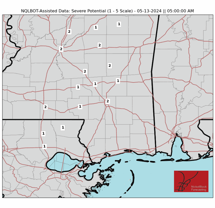
I want to give you guys some control here, so here are some of the data I’ve gathered related to the weather that you guys can tap-through (or click-through). That includes the Storm Potential Scale which is where we ask the computer to gives us an idea about where the strongest storms will be at a given time.
MAPS
Select Data Set:
I continue to work on updating these and adding to the availability of data. Let me know if you’d like to see something.
COUNTY BY COUNTY BREAKDOWN
Here is the breakdown, county-by-county, with respect to the severe weather threat for our coverage area.

If you felt like I’ve left out an county, please let me know. These take a while to make (even with NQLBOT, our AI weather-helper) and sometimes while going through and building each counties forecast, I skip over one when copying that forecast over to the site/app.
And yes, these forecasts are aided by NQLBOT, our AI weather helper. Hopefully he did a good job today!
Along I-20

Rankin County:
5p — 9p – As things get started, a few isolated storms are possible. A few may be severe. The main concerns are brief heavy rain, some lightning, gusty wind, small hail. Rainfall totals up to 1 inch possible.
10p — 2a – There is a chance for showers and storms. Some severe. the main concerns are heavy rain, frequent lightning, wind gusts up to 70mph, ping pong ball-sized hail, and a few tornadoes (up to EF3 in strength). Rainfall totals are estimated to be around 1-3 inches.
3a — 7a – All Clear! Though, there is a chance for some lingering brief heavy rain, some lightning, gusty wind, small hail. Rainfall totals up to 1 inch possible.
How it will impact you:
– Roads may be briefly impassable due to short-term flash flooding
– With a lot of lightning expected, make sure to be inside
– Trees may be knocked down, and scattered power outages are likely
– Hail damage is possible, park vehicles under cover if possible
– A Tornado Watch is likely
– Wind-driven hail is possible which could damaging siding, go through windows, and dent cars.
Best to be where you want to be by 8p
Scott County:
6p — 10p – As things get started, a few isolated storms are possible. A few may be severe. The main concerns are brief heavy rain, some lightning, gusty wind, small hail. Rainfall totals up to 1 inch possible.
11p — 3a – There is a chance for showers and storms. Some severe. the main concerns are heavy rain, frequent lightning, wind gusts up to 70mph, ping pong ball-sized hail, and a few tornadoes (up to EF2 in strength). Rainfall totals are estimated to be around 1-3 inches.
4a — 8a – All Clear! Though, there is a chance for some lingering brief heavy rain, some lightning, gusty wind, small hail. Rainfall totals up to 1 inch possible.
How it will impact you:
– Roads may be briefly impassable due to short-term flash flooding
– With a lot of lightning expected, make sure to be inside
– Trees may be knocked down, and scattered power outages are likely
– Hail damage is possible, park vehicles under cover if possible
– A Tornado Watch is likely
– Wind-driven hail is possible which could damaging siding, go through windows, and dent cars.
Best to be where you want to be by 9p
Newton County:
7p — 11p – As things get started, a few isolated storms are possible. A few may be severe. The main concerns are brief heavy rain, some lightning, gusty wind, small hail. Rainfall totals up to 1 inch possible.
12a — 4a – There is a chance for showers and storms. Some severe. the main concerns are heavy rain, frequent lightning, wind gusts up to 70mph, ping pong ball-sized hail, and a few tornadoes (up to EF2 in strength). Rainfall totals are estimated to be around 1-3 inches.
5a — 9a – All Clear! Though, there is a chance for some lingering brief heavy rain, some lightning, gusty wind, small hail. Rainfall totals up to 1 inch possible.
How it will impact you:
– Roads may be briefly impassable due to short-term flash flooding
– With a lot of lightning expected, make sure to be inside
– Trees may be knocked down, and scattered power outages are likely
– Hail damage is possible, park vehicles under cover if possible
– A Tornado Watch is liekly
– Wind-driven hail is possible which could damaging siding, go through windows, and dent cars.
Best to be where you want to be by 10p
Lauderdale County:
8p — 12a – As things get started, a few isolated storms are possible. A few may be severe. The main concerns are brief heavy rain, some lightning, gusty wind, small hail. Rainfall totals up to 1 inch possible.
1a — 5a – There is a chance for showers and storms. Some severe. the main concerns are heavy rain, frequent lightning, wind gusts up to 70mph, ping pong ball-sized hail, and a few tornadoes (up to EF2 in strength). Rainfall totals are estimated to be around 1-3 inches.
6a — 10a – All Clear! Though, there is a chance for some lingering brief heavy rain, some lightning, gusty wind, small hail. Rainfall totals up to 1 inch possible.
How it will impact you:
– Roads may be briefly impassable due to short-term flash flooding
– With a lot of lightning expected, make sure to be inside
– Trees may be knocked down, and scattered power outages are likely
– Hail damage is possible, park vehicles under cover if possible
– A Tornado Watch is likely
– Wind-driven hail is possible which could damaging siding, go through windows, and dent cars.
Best to be where you want to be by 11p
Near I-20
Simpson County:
5p — 9p – As things get started, a few isolated storms are possible. A few may be severe. The main concerns are brief heavy rain, some lightning, gusty wind, small hail. Rainfall totals up to 1 inch possible.
10p — 2a – There is a chance for showers and storms. Some severe. the main concerns are heavy rain, frequent lightning, wind gusts up to 70mph, ping pong ball-sized hail, and a few tornadoes (up to EF3 in strength). Rainfall totals are estimated to be around 1-3 inches.
3a — 7a – All Clear! Though, there is a chance for some lingering brief heavy rain, some lightning, gusty wind, small hail. Rainfall totals up to 1 inch possible.
How it will impact you:
– Roads may be briefly impassable due to short-term flash flooding
– With a lot of lightning expected, make sure to be inside
– Trees may be knocked down, and scattered power outages are likely
– Hail damage is possible, park vehicles under cover if possible
– A Tornado Watch is likely
– Wind-driven hail is possible which could damaging siding, go through windows, and dent cars.
Best to be where you want to be by 9p
Smith County:
6p — 10p – As things get started, a few isolated storms are possible. A few may be severe. The main concerns are brief heavy rain, some lightning, gusty wind, small hail. Rainfall totals up to 1 inch possible.
11p — 3a – There is a chance for showers and storms. Some severe. the main concerns are heavy rain, frequent lightning, wind gusts up to 70mph, ping pong ball-sized hail, and a few tornadoes (up to EF3 in strength). Rainfall totals are estimated to be around 1-3 inches.
4a — 8a – All Clear! Though, there is a chance for some lingering brief heavy rain, some lightning, gusty wind, small hail. Rainfall totals up to 1 inch possible.
How it will impact you:
– Roads may be briefly impassable due to short-term flash flooding
– With a lot of lightning expected, make sure to be inside
– Trees may be knocked down, and scattered power outages are likely
– Hail damage is possible, park vehicles under cover if possible
– A Tornado Watch is likely
– Wind-driven hail is possible which could damaging siding, go through windows, and dent cars.
Best to be where you want to be by 10p
Jasper County:
7p — 11p – As things get started, a few isolated storms are possible. A few may be severe. The main concerns are brief heavy rain, some lightning, gusty wind, small hail. Rainfall totals up to 1 inch possible.
12a — 4a – There is a chance for showers and storms. Some severe. the main concerns are heavy rain, frequent lightning, wind gusts up to 70mph, ping pong ball-sized hail, and a few tornadoes (up to EF2 in strength). Rainfall totals are estimated to be around 1-3 inches.
5a — 9a – All Clear! Though, there is a chance for some lingering brief heavy rain, some lightning, gusty wind, small hail. Rainfall totals up to 1 inch possible.
How it will impact you:
– Roads may be briefly impassable due to short-term flash flooding
– With a lot of lightning expected, make sure to be inside
– Trees may be knocked down, and scattered power outages are likely
– Hail damage is possible, park vehicles under cover if possible
– A Tornado Watch is likely
– Wind-driven hail is possible which could damaging siding, go through windows, and dent cars.
Best to be where you want to be by 11p
Clarke County:
8p — 12a – As things get started, a few isolated storms are possible. A few may be severe. The main concerns are brief heavy rain, some lightning, gusty wind, small hail. Rainfall totals up to 1 inch possible.
1a — 5a – There is a chance for showers and storms. Some severe. the main concerns are heavy rain, frequent lightning, wind gusts up to 70mph, ping pong ball-sized hail, and a few tornadoes (up to EF2 in strength). Rainfall totals are estimated to be around 1-3 inches.
6a — 10a – All Clear! Though, there is a chance for some lingering brief heavy rain, some lightning, gusty wind, small hail. Rainfall totals up to 1 inch possible.
How it will impact you:
– Roads may be briefly impassable due to short-term flash flooding
– With a lot of lightning expected, make sure to be inside
– Trees may be knocked down, and scattered power outages are likely
– Hail damage is possible, park vehicles under cover if possible
– A Tornado Watch is possible
– Wind-driven hail is possible which could damaging siding, go through windows, and dent cars.
Best to be where you want to be by 12a
HWY 84 Corridor
Lawrence County:
5p — 9p – As things get started, a few isolated storms are possible. A few may be severe. The main concerns are brief heavy rain, some lightning, gusty wind, small hail. Rainfall totals up to 1 inch possible.
10p — 2a – There is a chance for showers and storms. Some severe. the main concerns are heavy rain, frequent lightning, wind gusts up to 70mph, ping pong ball-sized hail, and a few tornadoes (up to EF3 in strength). Rainfall totals are estimated to be around 1-3 inches.
3a — 7a – All Clear! Though, there is a chance for some lingering brief heavy rain, some lightning, gusty wind, small hail. Rainfall totals up to 1 inch possible.
How it will impact you:
– Roads may be briefly impassable due to short-term flash flooding
– With a lot of lightning expected, make sure to be inside
– Trees may be knocked down, and scattered power outages are likely
– Hail damage is possible, park vehicles under cover if possible
– A Tornado Watch is likely
– Wind-driven hail is possible which could damaging siding, go through windows, and dent cars.
Best to be where you want to be by 9p
Jeff Davis County:
6p — 10p – As things get started, a few isolated storms are possible. A few may be severe. The main concerns are brief heavy rain, some lightning, gusty wind, small hail. Rainfall totals up to 1 inch possible.
11p — 3a – There is a chance for showers and storms. Some severe. the main concerns are heavy rain, frequent lightning, wind gusts up to 70mph, ping pong ball-sized hail, and a few tornadoes (up to EF3 in strength). Rainfall totals are estimated to be around 1-3 inches.
4a — 8a – All Clear! Though, there is a chance for some lingering brief heavy rain, some lightning, gusty wind, small hail. Rainfall totals up to 1 inch possible.
How it will impact you:
– Roads may be briefly impassable due to short-term flash flooding
– With a lot of lightning expected, make sure to be inside
– Trees may be knocked down, and scattered power outages are likely
– Hail damage is possible, park vehicles under cover if possible
– A Tornado Watch is likely
– Wind-driven hail is possible which could damaging siding, go through windows, and dent cars.
Best to be where you want to be by 10p
Covington County:
7p — 11p – As things get started, a few isolated storms are possible. A few may be severe. The main concerns are brief heavy rain, some lightning, gusty wind, small hail. Rainfall totals up to 1 inch possible.
12a — 4a – There is a chance for showers and storms. Some severe. the main concerns are heavy rain, frequent lightning, wind gusts up to 70mph, ping pong ball-sized hail, and a few tornadoes (up to EF3 in strength). Rainfall totals are estimated to be around 1-3 inches.
5a — 9a – All Clear! Though, there is a chance for some lingering brief heavy rain, some lightning, gusty wind, small hail. Rainfall totals up to 1 inch possible.
How it will impact you:
– Roads may be briefly impassable due to short-term flash flooding
– With a lot of lightning expected, make sure to be inside
– Trees may be knocked down, and scattered power outages are likely
– Hail damage is possible, park vehicles under cover if possible
– A Tornado Watch is likely
– Wind-driven hail is possible which could damaging siding, go through windows, and dent cars.
Best to be where you want to be by 11p
Jones County:
8p — 12a – As things get started, a few isolated storms are possible. A few may be severe. The main concerns are brief heavy rain, some lightning, gusty wind, small hail. Rainfall totals up to 1 inch possible.
1a — 5a – There is a chance for showers and storms. Some severe. the main concerns are heavy rain, frequent lightning, wind gusts up to 70mph, ping pong ball-sized hail, and a few tornadoes (up to EF2 in strength). Rainfall totals are estimated to be around 1-3 inches.
6a — 10a – All Clear! Though, there is a chance for some lingering brief heavy rain, some lightning, gusty wind, small hail. Rainfall totals up to 1 inch possible.
How it will impact you:
– Roads may be briefly impassable due to short-term flash flooding
– With a lot of lightning expected, make sure to be inside
– Trees may be knocked down, and scattered power outages are likely
– Hail damage is possible, park vehicles under cover if possible
– A Tornado Watch is likely
– Wind-driven hail is possible which could damaging siding, go through windows, and dent cars.
Best to be where you want to be by 12a
Wayne County:
9p — 1a – As things get started, a few isolated storms are possible. A few may be severe. The main concerns are brief heavy rain, some lightning, gusty wind, small hail. Rainfall totals up to 1 inch possible.
2a — 6a – There is a chance for showers and storms. Some severe. the main concerns are heavy rain, frequent lightning, wind gusts up to 70mph, ping pong ball-sized hail, and a few tornadoes (up to EF2 in strength). Rainfall totals are estimated to be around 1-3 inches.
7a — 11a – All Clear! Though, there is a chance for some lingering brief heavy rain, some lightning, gusty wind, small hail. Rainfall totals up to 1 inch possible.
How it will impact you:
– Roads may be briefly impassable due to short-term flash flooding
– With a lot of lightning expected, make sure to be inside
– Trees may be knocked down, and scattered power outages are likely
– Hail damage is possible, park vehicles under cover if possible
– A Tornado Watch is likely
– Wind-driven hail is possible which could damaging siding, go through windows, and dent cars.
Best to be where you want to be by 1a
HWY 98 Corridor
Walthall County:
6p — 10p – As things get started, a few isolated storms are possible. A few may be severe. The main concerns are brief heavy rain, some lightning, gusty wind, small hail. Rainfall totals up to 1 inch possible.
11p — 3a – There is a chance for showers and storms. Some severe. the main concerns are heavy rain, frequent lightning, wind gusts up to 70mph, ping pong ball-sized hail, and a few tornadoes (up to EF3 in strength). Rainfall totals are estimated to be around 1-3 inches.
4a — 8a – All Clear! Though, there is a chance for some lingering brief heavy rain, some lightning, gusty wind, small hail. Rainfall totals up to 1 inch possible.
How it will impact you:
– Roads may be briefly impassable due to short-term flash flooding
– With a lot of lightning expected, make sure to be inside
– Trees may be knocked down, and scattered power outages are likely
– Hail damage is possible, park vehicles under cover if possible
– A Tornado Watch is likely
– Wind-driven hail is possible which could damaging siding, go through windows, and dent cars.
Best to be where you want to be by 10p
Marion County:
7p — 11p – As things get started, a few isolated storms are possible. A few may be severe. The main concerns are brief heavy rain, some lightning, gusty wind, small hail. Rainfall totals up to 1 inch possible.
12a — 4a – There is a chance for showers and storms. Some severe. the main concerns are heavy rain, frequent lightning, wind gusts up to 70mph, ping pong ball-sized hail, and a few tornadoes (up to EF3 in strength). Rainfall totals are estimated to be around 1-3 inches.
5a — 9a – All Clear! Though, there is a chance for some lingering brief heavy rain, some lightning, gusty wind, small hail. Rainfall totals up to 1 inch possible.
How it will impact you:
– Roads may be briefly impassable due to short-term flash flooding
– With a lot of lightning expected, make sure to be inside
– Trees may be knocked down, and scattered power outages are likely
– Hail damage is possible, park vehicles under cover if possible
– A Tornado Watch is likely
– Wind-driven hail is possible which could damaging siding, go through windows, and dent cars.
Best to be where you want to be by 11p
Lamar County:
8p — 12a – As things get started, a few isolated storms are possible. A few may be severe. The main concerns are brief heavy rain, some lightning, gusty wind, small hail. Rainfall totals up to 1 inch possible.
1a — 5a – There is a chance for showers and storms. Some severe. the main concerns are heavy rain, frequent lightning, wind gusts up to 70mph, ping pong ball-sized hail, and a few tornadoes (up to EF3 in strength). Rainfall totals are estimated to be around 1-3 inches.
6a — 10a – All Clear! Though, there is a chance for some lingering brief heavy rain, some lightning, gusty wind, small hail. Rainfall totals up to 1 inch possible.
How it will impact you:
– Roads may be briefly impassable due to short-term flash flooding
– With a lot of lightning expected, make sure to be inside
– Trees may be knocked down, and scattered power outages are likely
– Hail damage is possible, park vehicles under cover if possible
– A Tornado Watch is likely
– Wind-driven hail is possible which could damaging siding, go through windows, and dent cars.
Best to be where you want to be by 12a
Forrest County:
9p — 1a – As things get started, a few isolated storms are possible. A few may be severe. The main concerns are brief heavy rain, some lightning, gusty wind, small hail. Rainfall totals up to 1 inch possible.
2a — 6a – There is a chance for showers and storms. Some severe. the main concerns are heavy rain, frequent lightning, wind gusts up to 70mph, ping pong ball-sized hail, and a few tornadoes (up to EF2 in strength). Rainfall totals are estimated to be around 1-3 inches.
7a — 11a – All Clear! Though, there is a chance for some lingering brief heavy rain, some lightning, gusty wind, small hail. Rainfall totals up to 1 inch possible.
How it will impact you:
– Roads may be briefly impassable due to short-term flash flooding
– With a lot of lightning expected, make sure to be inside
– Trees may be knocked down, and scattered power outages are likely
– Hail damage is possible, park vehicles under cover if possible
– A Tornado Watch is likely
– Wind-driven hail is possible which could damaging siding, go through windows, and dent cars.
Best to be where you want to be by 1a
Perry County:
10p — 2a – As things get started, a few isolated storms are possible. A few may be severe. The main concerns are brief heavy rain, some lightning, gusty wind, small hail. Rainfall totals up to 1 inch possible.
3a — 7a – There is a chance for showers and storms. Some severe. the main concerns are heavy rain, frequent lightning, wind gusts up to 70mph, ping pong ball-sized hail, and a few tornadoes (up to EF2 in strength). Rainfall totals are estimated to be around 1-3 inches.
8a — 12a – All Clear! Though, there is a chance for some lingering brief heavy rain, some lightning, gusty wind, small hail. Rainfall totals up to 1 inch possible.
How it will impact you:
– Roads may be briefly impassable due to short-term flash flooding
– With a lot of lightning expected, make sure to be inside
– Trees may be knocked down, and scattered power outages are likely
– Hail damage is possible, park vehicles under cover if possible
– A Tornado Watch is likely
– Wind-driven hail is possible which could damaging siding, go through windows, and dent cars.
Best to be where you want to be by 2a
Greene County:
11p — 3a – As things get started, a few isolated storms are possible. A few may be severe. The main concerns are brief heavy rain, some lightning, gusty wind, small hail. Rainfall totals up to 1 inch possible.
4a — 8a – There is a chance for showers and storms. Some severe. the main concerns are heavy rain, frequent lightning, wind gusts up to 70mph, ping pong ball-sized hail, and a few tornadoes (up to EF2 in strength). Rainfall totals are estimated to be around 1-3 inches.
9a — 1p – All Clear! Though, there is a chance for some lingering brief heavy rain, some lightning, gusty wind, small hail. Rainfall totals up to 1 inch possible.
How it will impact you:
– Roads may be briefly impassable due to short-term flash flooding
– With a lot of lightning expected, make sure to be inside
– Trees may be knocked down, and scattered power outages are likely
– Hail damage is possible, park vehicles under cover if possible
– A Tornado Watch is possible
– Wind-driven hail is possible which could damaging siding, go through windows, and dent cars.
Best to be where you want to be by 3a
HWY 26 Corridor
Pearl River County:
8p — 12a – As things get started, a few isolated storms are possible. A few may be severe. The main concerns are brief heavy rain, some lightning, gusty wind, small hail. Rainfall totals up to 1 inch possible.
1a – 5a – There is a chance for showers and storms. Some severe. the main concerns are heavy rain, frequent lightning, wind gusts up to 70mph, ping pong ball-sized hail, and a few tornadoes (up to EF2 in strength). Rainfall totals are estimated to be around 1-3 inches.
6a — 10a – All Clear! Though, there is a chance for some lingering brief heavy rain, some lightning, gusty wind, small hail. Rainfall totals up to 1 inch possible.
How it will impact you:
– Roads may be briefly impassable due to short-term flash flooding
– With a lot of lightning expected, make sure to be inside
– Trees may be knocked down, and scattered power outages are likely
– Hail damage is possible, park vehicles under cover if possible
– A Tornado Watch is possible
– Wind-driven hail is possible which could damaging siding, go through windows, and dent cars.
Best to be where you want to be by 12a
Stone County:
9p — 1a – As things get started, a few isolated storms are possible. A few may be severe. The main concerns are brief heavy rain, some lightning, gusty wind, small hail. Rainfall totals up to 1 inch possible.
2a — 6a – There is a chance for showers and storms. Some severe. the main concerns are heavy rain, frequent lightning, wind gusts up to 70mph, ping pong ball-sized hail, and a few tornadoes (up to EF2 in strength). Rainfall totals are estimated to be around 1-3 inches.
7a — 11a – All Clear! Though, there is a chance for some lingering brief heavy rain, some lightning, gusty wind, small hail. Rainfall totals up to 1 inch possible.
How it will impact you:
– Roads may be briefly impassable due to short-term flash flooding
– With a lot of lightning expected, make sure to be inside
– Trees may be knocked down, and scattered power outages are likely
– Hail damage is possible, park vehicles under cover if possible
– A Tornado Watch is possible
– Wind-driven hail is possible which could damaging siding, go through windows, and dent cars.
Best to be where you want to be by 1a
George County:
10p — 2a – As things get started, a few isolated storms are possible. A few may be severe. The main concerns are brief heavy rain, some lightning, gusty wind, small hail. Rainfall totals up to 1 inch possible.
3a — 7a – There is a chance for showers and storms. Some severe. the main concerns are heavy rain, frequent lightning, wind gusts up to 70mph, ping pong ball-sized hail, and a few tornadoes (up to EF2 in strength). Rainfall totals are estimated to be around 1-3 inches.
8a — 12a – All Clear! Though, there is a chance for some lingering brief heavy rain, some lightning, gusty wind, small hail. Rainfall totals up to 1 inch possible.
How it will impact you:
– Roads may be briefly impassable due to short-term flash flooding
– With a lot of lightning expected, make sure to be inside
– Trees may be knocked down, and scattered power outages are likely
– Hail damage is possible, park vehicles under cover if possible
– A Tornado Watch is possible
– Wind-driven hail is possible which could damaging siding, go through windows, and dent cars.
Best to be where you want to be by 2a
Coastal Mississippi
Hancock County:
8p — 12a – As things get started, a few isolated storms are possible. A few may be severe. The main concerns are brief heavy rain, some lightning, gusty wind, small hail. Rainfall totals up to 1 inch possible.
1a – 5a – There is a chance for showers and storms. Some severe. the main concerns are heavy rain, frequent lightning, wind gusts up to 70mph, ping pong ball-sized hail, and a few tornadoes (up to EF1 in strength). Rainfall totals are estimated to be around 1-3 inches.
6a — 10a – All Clear! Though, there is a chance for some lingering brief heavy rain, some lightning, gusty wind, small hail. Rainfall totals up to 1 inch possible.
How it will impact you:
– Roads may be briefly impassable due to short-term flash flooding
– With a lot of lightning expected, make sure to be inside
– Trees may be knocked down, and scattered power outages are likely
– Hail damage is possible, park vehicles under cover if possible
– A Tornado Watch is possible
– Wind-driven hail is possible which could damaging siding, go through windows, and dent cars.
Best to be where you want to be by 12a
Harrison County:
9p — 1a – As things get started, a few isolated storms are possible. A few may be severe. The main concerns are brief heavy rain, some lightning, gusty wind, small hail. Rainfall totals up to 1 inch possible.
2a — 6a – There is a chance for showers and storms. Some severe. the main concerns are heavy rain, frequent lightning, wind gusts up to 70mph, ping pong ball-sized hail, and a few tornadoes (up to EF1 in strength). Rainfall totals are estimated to be around 1-3 inches.
7a — 11a – All Clear! Though, there is a chance for some lingering brief heavy rain, some lightning, gusty wind, small hail. Rainfall totals up to 1 inch possible.
How it will impact you:
– Roads may be briefly impassable due to short-term flash flooding
– With a lot of lightning expected, make sure to be inside
– Trees may be knocked down, and scattered power outages are likely
– Hail damage is possible, park vehicles under cover if possible
– A Tornado Watch is possible
– Wind-driven hail is possible which could damaging siding, go through windows, and dent cars.
Best to be where you want to be by 1a
Jackson County:
10p — 2a – As things get started, a few isolated storms are possible. A few may be severe. The main concerns are brief heavy rain, some lightning, gusty wind, small hail. Rainfall totals up to 1 inch possible.
3a — 7a – There is a chance for showers and storms. Some severe. the main concerns are heavy rain, frequent lightning, wind gusts up to 70mph, ping pong ball-sized hail, and a few tornadoes (up to EF1 in strength). Rainfall totals are estimated to be around 1-3 inches.
8a — 12a – All Clear! Though, there is a chance for some lingering brief heavy rain, some lightning, gusty wind, small hail. Rainfall totals up to 1 inch possible.
How it will impact you:
– Roads may be briefly impassable due to short-term flash flooding
– With a lot of lightning expected, make sure to be inside
– Trees may be knocked down, and scattered power outages are likely
– Hail damage is possible, park vehicles under cover if possible
– A Tornado Watch is possible
– Wind-driven hail is possible which could damaging siding, go through windows, and dent cars.
Best to be where you want to be by 2a
LOUISIANA PARISHES
St. Helena Parish:
6p — 10p – As things get started, a few isolated storms are possible. A few may be severe. The main concerns are brief heavy rain, some lightning, gusty wind, small hail. Rainfall totals up to 1 inch possible.
11p — 3a – There is a chance for showers and storms. Some severe. the main concerns are heavy rain, frequent lightning, wind gusts up to 70mph, ping pong ball-sized hail, and a few tornadoes (up to EF3 in strength). Rainfall totals are estimated to be around 1-3 inches.
4a — 8a – All Clear! Though, there is a chance for some lingering brief heavy rain, some lightning, gusty wind, small hail. Rainfall totals up to 1 inch possible.
How it will impact you:
– Roads may be briefly impassable due to short-term flash flooding
– With a lot of lightning expected, make sure to be inside
– Trees may be knocked down, and scattered power outages are likely
– Hail damage is possible, park vehicles under cover if possible
– A Tornado Watch is likely
– Wind-driven hail is possible which could damaging siding, go through windows, and dent cars.
Best to be where you want to be by 10p
Livingston Parish
6p — 10p – As things get started, a few isolated storms are possible. A few may be severe. The main concerns are brief heavy rain, some lightning, gusty wind, small hail. Rainfall totals up to 1 inch possible.
11p — 3a – There is a chance for showers and storms. Some severe. the main concerns are heavy rain, frequent lightning, wind gusts up to 70mph, ping pong ball-sized hail, and a few tornadoes (up to EF3 in strength). Rainfall totals are estimated to be around 1-3 inches.
4a — 8a – All Clear! Though, there is a chance for some lingering brief heavy rain, some lightning, gusty wind, small hail. Rainfall totals up to 1 inch possible.
How it will impact you:
– Roads may be briefly impassable due to short-term flash flooding
– With a lot of lightning expected, make sure to be inside
– Trees may be knocked down, and scattered power outages are likely
– Hail damage is possible, park vehicles under cover if possible
– A Tornado Watch is possible
– Wind-driven hail is possible which could damaging siding, go through windows, and dent cars.
Best to be where you want to be by 10p
Tangipahoa Parish
7p — 11p – As things get started, a few isolated storms are possible. A few may be severe. The main concerns are brief heavy rain, some lightning, gusty wind, small hail. Rainfall totals up to 1 inch possible.
12a — 4a – There is a chance for showers and storms. Some severe. the main concerns are heavy rain, frequent lightning, wind gusts up to 70mph, ping pong ball-sized hail, and a few tornadoes (up to EF3 in strength). Rainfall totals are estimated to be around 1-3 inches.
5a — 9a – All Clear! Though, there is a chance for some lingering brief heavy rain, some lightning, gusty wind, small hail. Rainfall totals up to 1 inch possible.
How it will impact you:
– Roads may be briefly impassable due to short-term flash flooding
– With a lot of lightning expected, make sure to be inside
– Trees may be knocked down, and scattered power outages are likely
– Hail damage is possible, park vehicles under cover if possible
– A Tornado Watch is likely
– Wind-driven hail is possible which could damaging siding, go through windows, and dent cars.
Best to be where you want to be by 11p
Washington Parish
8p — 12a – As things get started, a few isolated storms are possible. A few may be severe. The main concerns are brief heavy rain, some lightning, gusty wind, small hail. Rainfall totals up to 1 inch possible.
1a — 5a – There is a chance for showers and storms. Some severe. the main concerns are heavy rain, frequent lightning, wind gusts up to 70mph, ping pong ball-sized hail, and a few tornadoes (up to EF3 in strength). Rainfall totals are estimated to be around 1-3 inches.
6a — 10a – All Clear! Though, there is a chance for some lingering brief heavy rain, some lightning, gusty wind, small hail. Rainfall totals up to 1 inch possible.
How it will impact you:
– Roads may be briefly impassable due to short-term flash flooding
– With a lot of lightning expected, make sure to be inside
– Trees may be knocked down, and scattered power outages are likely
– Hail damage is possible, park vehicles under cover if possible
– A Tornado Watch is likely
– Wind-driven hail is possible which could damaging siding, go through windows, and dent cars.
Best to be where you want to be by 12a
St Tammany Parish
8p — 12a – As things get started, a few isolated storms are possible. A few may be severe. The main concerns are brief heavy rain, some lightning, gusty wind, small hail. Rainfall totals up to 1 inch possible.
1a — 5a – There is a chance for showers and storms. Some severe. the main concerns are heavy rain, frequent lightning, wind gusts up to 70mph, ping pong ball-sized hail, and a few tornadoes (up to EF2 in strength). Rainfall totals are estimated to be around 1-3 inches.
6a — 10a – All Clear! Though, there is a chance for some lingering brief heavy rain, some lightning, gusty wind, small hail. Rainfall totals up to 1 inch possible.
How it will impact you:
– Roads may be briefly impassable due to short-term flash flooding
– With a lot of lightning expected, make sure to be inside
– Trees may be knocked down, and scattered power outages are likely
– Hail damage is possible, park vehicles under cover if possible
– A Tornado Watch is possible
– Wind-driven hail is possible which could damaging siding, go through windows, and dent cars.
Best to be where you want to be by 12a
Orleans Parish
8p — 12a – As things get started, a few isolated storms are possible. A few may be severe. The main concerns are brief heavy rain, some lightning, gusty wind, small hail. Rainfall totals up to 1 inch possible.
1a — 5a – There is a chance for showers and storms. Some severe. the main concerns are heavy rain, frequent lightning, wind gusts up to 70mph, quarter-sized hail, and a few tornadoes (up to EF2 in strength). Rainfall totals are estimated to be around 1-3 inches.
6a — 10a – All Clear! Though, there is a chance for some lingering brief heavy rain, some lightning, gusty wind, small hail. Rainfall totals up to 1 inch possible.
How it will impact you:
– Roads may be briefly impassable due to short-term flash flooding
– With a lot of lightning expected, make sure to be inside
– Trees may be knocked down, and scattered power outages are likely
– A Tornado Watch is possible
Best to be where you want to be by 12a
ALABAMA COUNTIES

Sumter County:
8p — 12a – As things get started, a few isolated storms are possible. A few may be severe. The main concerns are brief heavy rain, some lightning, gusty wind, small hail. Rainfall totals up to 1 inch possible.
1a — 5a – There is a chance for showers and storms. Some severe. the main concerns are heavy rain, frequent lightning, wind gusts up to 70mph, ping pong ball-sized hail, and a few tornadoes (up to EF2 in strength). Rainfall totals are estimated to be around 1-3 inches.
6a — 10a – All Clear! Though, there is a chance for some lingering brief heavy rain, some lightning, gusty wind, small hail. Rainfall totals up to 1 inch possible.
How it will impact you:
– Roads may be briefly impassable due to short-term flash flooding
– With a lot of lightning expected, make sure to be inside
– Trees may be knocked down, and scattered power outages are likely
– Hail damage is possible, park vehicles under cover if possible
– A Tornado Watch is possible
– Wind-driven hail is possible which could damaging siding, go through windows, and dent cars.
Best to be where you want to be by 12a
Choctaw County:
8p — 12a – As things get started, a few isolated storms are possible. A few may be severe. The main concerns are brief heavy rain, some lightning, gusty wind, small hail. Rainfall totals up to 1 inch possible.
1a — 5a – There is a chance for showers and storms. Some severe. the main concerns are heavy rain, frequent lightning, wind gusts up to 70mph, ping pong ball-sized hail, and a few tornadoes (up to EF2 in strength). Rainfall totals are estimated to be around 1-3 inches.
6a — 10a – All Clear! Though, there is a chance for some lingering brief heavy rain, some lightning, gusty wind, small hail. Rainfall totals up to 1 inch possible.
How it will impact you:
– Roads may be briefly impassable due to short-term flash flooding
– With a lot of lightning expected, make sure to be inside
– Trees may be knocked down, and scattered power outages are likely
– Hail damage is possible, park vehicles under cover if possible
– A Tornado Watch is possible
– Wind-driven hail is possible which could damaging siding, go through windows, and dent cars.
Best to be where you want to be by 12a
Washington County
11p — 3a – As things get started, a few isolated storms are possible. A few may be severe. The main concerns are brief heavy rain, some lightning, gusty wind, small hail. Rainfall totals up to 1 inch possible.
4a — 8a – There is a chance for showers and storms. Some severe. the main concerns are heavy rain, frequent lightning, wind gusts up to 70mph, quarter-sized hail, and a few tornadoes (up to EF2 in strength). Rainfall totals are estimated to be around 1-3 inches.
9a — 1p – All Clear! Though, there is a chance for some lingering brief heavy rain, some lightning, gusty wind, small hail. Rainfall totals up to 1 inch possible.
How it will impact you:
– Roads may be briefly impassable due to short-term flash flooding
– With a lot of lightning expected, make sure to be inside
– Trees may be knocked down, and scattered power outages are likely
– A Tornado Watch is possible
Best to be where you want to be by 3a
Mobile County
10p — 2a – As things get started, a few isolated storms are possible. A few may be severe. The main concerns are brief heavy rain, some lightning, gusty wind, small hail. Rainfall totals up to 1 inch possible.
3a — 7a – There is a chance for showers and storms. Some severe. the main concerns are heavy rain, frequent lightning, wind gusts up to 70mph, quarter-sized hail, and a few tornadoes (up to EF2 in strength). Rainfall totals are estimated to be around 1-3 inches.
8a — 12a – All Clear! Though, there is a chance for some lingering brief heavy rain, some lightning, gusty wind, small hail. Rainfall totals up to 1 inch possible.
How it will impact you:
– Roads may be briefly impassable due to short-term flash flooding
– With a lot of lightning expected, make sure to be inside
– Trees may be knocked down, and scattered power outages are likely
– A Tornado Watch is possible
Best to be where you want to be by 2a


Can you also cover I-55 South corridor? We are in Copiah County