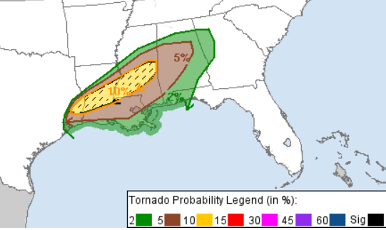
For a small update on the severe weather, the SPC has upgraded our risk from Slight to Enhanced (3/5). The tornado threat has shifted further north and west towards Natchez along the Highway 84 corridor to Meridian.
Many cells will develop east of the Pearl River around 3pm and move further north. By 5pm, cells will develop from Pike County northeast to Lauderdale County and move further north. Some of these cells will be tornadic and may produce some hail and strong winds. From 8-10pm these storms will stay north towards I-20 before they begin to dissipate. Around this time, we’ll see a lull until around 4am when the cold front pushes east into Mississippi sparking some more slightly organized cells early into the morning. These will develop east of I-55 and move east towards I-59 by sunrise. The line will form from the coastline north of I-20, so many people just waking up will need to be on alert.
The Rest of the Week
We’ll see another period of relatively mild weather for the rest of the week after the storm clears out on Monday. Highs will gradually increase from the mid 50s on Tuesday to the mid 60s by Friday and lows in the upper 30s to mid 40s by the end of the week. We’ll see an increase in clouds by mid-week as well.

By Friday, an elongated front will push further south due to a strong northern plains high pressure system behind it. Some weak southerly flow from the Gulf will provide some moisture to feed some rain to the front. Towards the subtropics around Mexico, a low pressure system will develop providing the southerly moisture to form a weaker front beside the front in the mid-latitudes. We’ll see a fair bit of rain during Saturday into Sunday.
[wpcode id=”41179″]
Regional Day-to-Day Forecast
This Afternoon – Showers likely and possibly a thunderstorm. Some of the storms could be severe. Mostly cloudy, with a high near 75. South wind 5 to 10 mph, with gusts as high as 20 mph. Chance of precipitation is 70%. New rainfall amounts of less than a tenth of an inch, except higher amounts possible in thunderstorms.
Tonight – Showers and thunderstorms likely, then showers and possibly a thunderstorm after midnight. Some of the storms could be severe. Low around 58. South wind 5 to 10 mph, with gusts as high as 20 mph. Chance of precipitation is 80%. New rainfall amounts between a quarter and half of an inch possible.
Monday – Showers and thunderstorms likely before noon. Partly sunny, with a temperature rising to near 65 by noon, then falling to around 54 during the remainder of the day. West wind 10 to 15 mph, with gusts as high as 30 mph. Chance of precipitation is 60%. New precipitation amounts of less than a tenth of an inch, except higher amounts possible in thunderstorms.
Monday Night – Mostly cloudy, with a low around 38. West northwest wind 10 to 15 mph, with gusts as high as 25 mph.
Tuesday – Sunny, with a high near 59. North northwest wind 5 to 10 mph.
Tuesday Night – Mostly clear, with a low around 35. North northwest wind around 5 mph becoming calm.
Wednesday – Sunny, with a high near 65. Calm wind becoming southeast around 5 mph in the afternoon.
Wednesday Night – Partly cloudy, with a low around 39. Southeast wind around 5 mph becoming calm in the evening.
Thursday – Mostly sunny, with a high near 69. Calm wind.
Thursday Night – Mostly cloudy, with a low around 48.
Friday – A 40 percent chance of showers. Mostly cloudy, with a high near 63.
Friday Night – Showers likely. Mostly cloudy, with a low around 49. Chance of precipitation is 70%.
Saturday – Showers likely. Mostly cloudy, with a high near 58. Chance of precipitation is 60%.
[wpcode id=”41149″]


