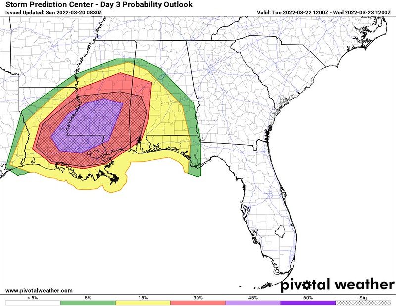
The SPC has highlighted the region with a Risk for severe weather on Tuesday and into Wednesday morning. The highest risk is across parts of Louisiana and western Mississippi where a Moderate Risk, that is a “4” on the 1-to-5 scale where “5” is the highest risk for the most significant severe weather, has been issued.

I could dive into all the stats and the numbers, but sadly, I don’t have a ton of time this morning and I spent most of it writing the county-by-county breakdown below. I will do one in the coming 24 hours, but not this morning.
Suffice to say, though, that this is a particularly potent setup. While not everyone will see severe weather, the chance that each next person sees a severe storms is higher Tuesday than it was last week. By a lot.
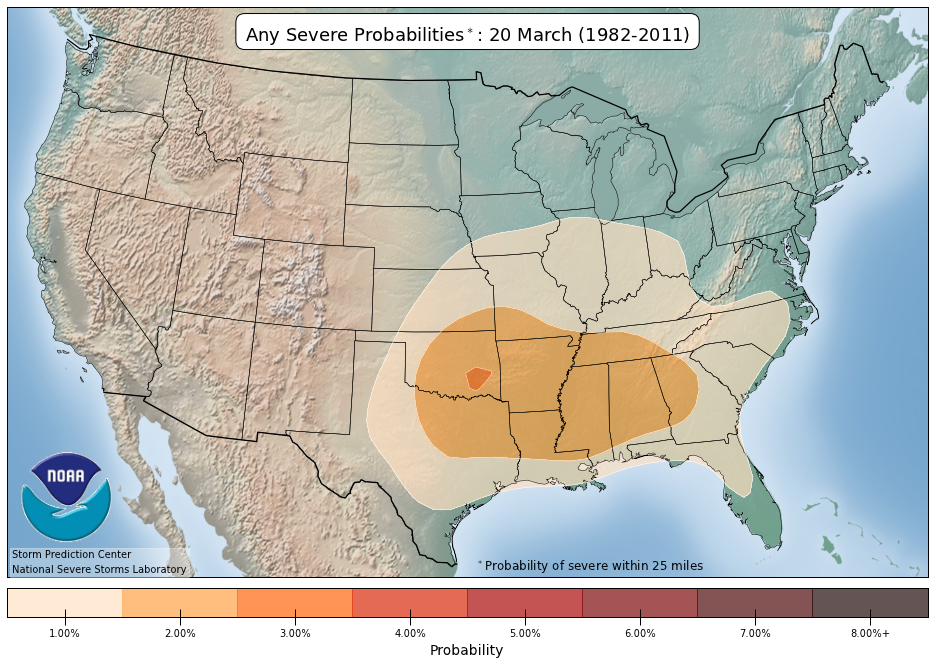
The average historical risk for a severe storm is around two-percent, according to the SPC.
According to the SPC, Tuesday the risk is 45-percent. or about 22-times higher than average. And the hatched area indicates that not only is severe weather possible, but the SPC is concerned about significant severe weather (wind in excess of 70mph, hail greater than 2″ or a tornado stronger than EF-2) occurring.
The parameter space is definitely conducive for the potential for severe weather. But remember that a potential doesn’t mean a guarantee. There are things that may shake out to limit the threat for some areas while enhancing the risk for others. All of those things will be hashed out during the next 48 hours.
County-by-County Timeline
Things are still pretty far out so I cast a pretty wide net here with the timeline. Please- PLEASE! – check back for updates as this timeline is likely to change. Not “could change” but likely to change. Not by a ton but by a few hours here and there.
Louisiana
St. Helena Parish
Tuesday 10a-4p — Isolated showers with few rumbles of thunder developing early, very few (if any) storms may be strong to severe before 1p. Main threats with any storm will be heavy rain, frequent lightning, gusty wind, small hail, and a tornado can not be ruled out.
Tuesday 4p-10p — Showers and storms likely, many strong with a handful severe. Main threats with stronger storms will be very heavy rain, frequent lightning, wind gusts up to 70mph, hail up to the size of quarters, and the potential for a tornado (up to EF4 in strength).
Tuesday 10p-Wednesday 4a — Storms ending. Turning cooler and breezy.
Tangipahoa Parish
Tuesday 10a-4p — Isolated showers with few rumbles of thunder developing early, very few (if any) storms may be strong to severe before 1p. Main threats with any storm will be heavy rain, frequent lightning, gusty wind, small hail, and a tornado can not be ruled out.
Tuesday 4p-10p — Showers and storms likely, many strong with a handful severe. Main threats with stronger storms will be very heavy rain, frequent lightning, wind gusts up to 70mph, hail up to the size of quarters, and the potential for a tornado (up to EF4 in strength).
Tuesday 10p-Wednesday 4a — Storms ending. Turning cooler and breezy.
Washington Parish
Tuesday 10a-4p — Isolated showers with few rumbles of thunder developing early, very few (if any) storms may be strong to severe before 1p. Main threats with any storm will be heavy rain, frequent lightning, gusty wind, small hail, and a tornado can not be ruled out.
Tuesday 4p-10p — Showers and storms likely, many strong with a handful severe. Main threats with stronger storms will be very heavy rain, frequent lightning, wind gusts up to 70mph, hail up to the size of quarters, and the potential for a tornado (up to EF4 in strength).
Tuesday 10p-Wednesday 4a — Storms ending. Turning cooler and breezy.
Livingston Parish
Tuesday 10a-4p — Isolated showers with few rumbles of thunder developing early, very few (if any) storms may be strong to severe before 1p. Main threats with any storm will be heavy rain, frequent lightning, gusty wind, small hail, and a tornado can not be ruled out.
Tuesday 4p-10p — Showers and storms likely, many strong with a handful severe. Main threats with stronger storms will be very heavy rain, frequent lightning, wind gusts up to 70mph, hail up to the size of quarters, and the potential for a tornado (up to EF4 in strength).
Tuesday 10p-Wednesday 4a — Storms ending. Turning cooler and breezy.
St. Tammany Parish
Tuesday 10a-4p — Isolated showers with few rumbles of thunder developing early, very few (if any) storms may be strong to severe before 1p. Main threats with any storm will be heavy rain, frequent lightning, gusty wind, small hail, and a tornado can not be ruled out.
Tuesday 4p-10p — Showers and storms likely, many strong with a handful severe. Main threats with stronger storms will be very heavy rain, frequent lightning, wind gusts up to 70mph, hail up to the size of quarters, and the potential for a tornado (up to EF4 in strength).
Tuesday 10p-Wednesday 4a — Storms ending. Turning cooler and breezy.
Mississippi
NEAR I-20
Copiah County
Tuesday 10a-4p — Isolated showers with few rumbles of thunder developing early, very few (if any) storms may be strong to severe before 1p. Main threats with any storm will be heavy rain, frequent lightning, gusty wind, small hail, and a tornado can not be ruled out.
Tuesday 4p-10p — Showers and storms likely, many strong with a handful severe. Main threats with stronger storms will be very heavy rain, frequent lightning, wind gusts up to 70mph, hail up to the size of quarters, and the potential for a tornado (up to EF4 in strength).
Tuesday 10p-Wednesday 4a — Storms ending. Turning cooler and breezy.
Simpson County
Tuesday 10a-4p — Isolated showers with few rumbles of thunder developing, very few (if any) storms may be strong to severe. Main threats with any storm will be heavy rain, frequent lightning, gusty wind, small hail, and a tornado can not be ruled out.
Tuesday 4p-10p — Showers and storms likely, many strong with a handful severe. Main threats with stronger storms will be very heavy rain, frequent lightning, wind gusts up to 70mph, hail up to the size of quarters, and the potential for a tornado (up to EF4 in strength).
Tuesday 10p-Wednesday 4a — Showers and storms ending. Few remaining storms will be strong, very few, if any, will be severe. Main threats with any storm will be heavy rain, frequent lightning, gusty wind, small hail, and a tornado can not be ruled out.
Wednesday 4a-10p — Turning cooler and breezy.
Smith County
Tuesday 10a-4p — Isolated showers with few rumbles of thunder developing, very few (if any) storms may be strong to severe. Main threats with any storm will be heavy rain, frequent lightning, gusty wind, small hail, and a tornado can not be ruled out.
Tuesday 4p-10p — Showers and storms likely, many strong with a handful severe. Main threats with stronger storms will be very heavy rain, frequent lightning, wind gusts up to 70mph, hail up to the size of quarters, and the potential for a tornado (up to EF4 in strength).
Tuesday 10p-Wednesday 4a — Showers and storms ending. Few remaining storms will be strong, very few, if any, will be severe. Main threats with any storm will be heavy rain, frequent lightning, gusty wind, small hail, and a tornado can not be ruled out.
Wednesday 4a-10p — Turning cooler and breezy.
Jasper County
Tuesday 10a-4p — Isolated showers with few rumbles of thunder developing, very few (if any) storms may be strong to severe. Main threats with any storm will be heavy rain, frequent lightning, gusty wind, small hail, and a tornado can not be ruled out.
Tuesday 4p-10p — Showers and storms likely, many strong with a handful severe. Main threats with stronger storms will be very heavy rain, frequent lightning, wind gusts up to 70mph, hail up to the size of quarters, and the potential for a tornado (up to EF4 in strength).
Tuesday 10p-Wednesday 4a — Showers and storms ending. Few remaining storms will be strong, very few, if any, will be severe. Main threats with any storm will be heavy rain, frequent lightning, gusty wind, small hail, and a tornado can not be ruled out.
Wednesday 4a-10p — Turning cooler and breezy.
Clarke County
Tuesday 10a-4p — Isolated showers with few rumbles of thunder developing, very few (if any) storms may be strong to severe. Main threats with any storm will be heavy rain, frequent lightning, gusty wind, small hail, and a tornado can not be ruled out.
Tuesday 4p-10p — Showers and storms likely, many strong with a handful severe. Main threats with stronger storms will be very heavy rain, frequent lightning, wind gusts up to 70mph, hail up to the size of quarters, and the potential for a tornado (up to EF4 in strength).
Tuesday 10p-Wednesday 4a — Showers and storms likely, many strong with a handful severe. Main threats with stronger storms will be very heavy rain, frequent lightning, wind gusts up to 70mph, hail up to the size of quarters, and the potential for a tornado (up to EF4 in strength).
Wednesday 4a-10p — Storms ending. Turning cooler and breezy.
HIGHWAY 84 CORRIDOR
Lincoln County
Tuesday 10a-4p — Isolated showers with few rumbles of thunder developing early, very few (if any) storms may be strong to severe before 1p. Main threats with any storm will be heavy rain, frequent lightning, gusty wind, small hail, and a tornado can not be ruled out.
Tuesday 4p-10p — Showers and storms likely, many strong with a handful severe. Main threats with stronger storms will be very heavy rain, frequent lightning, wind gusts up to 70mph, hail up to the size of quarters, and the potential for a tornado (up to EF4 in strength).
Tuesday 10p-Wednesday 4a — Showers and storms ending. Few remaining storms will be strong, very few, if any, will be severe. Main threats with any storm will be heavy rain, frequent lightning, gusty wind, small hail, and a tornado can not be ruled out.
Wednesday 4a-10p — Turning cooler and breezy.
Lawrence County
Tuesday 10a-4p — Isolated showers with few rumbles of thunder developing early, very few (if any) storms may be strong to severe before 1p. Main threats with any storm will be heavy rain, frequent lightning, gusty wind, small hail, and a tornado can not be ruled out.
Tuesday 4p-10p — Showers and storms likely, many strong with a handful severe. Main threats with stronger storms will be very heavy rain, frequent lightning, wind gusts up to 70mph, hail up to the size of quarters, and the potential for a tornado (up to EF4 in strength).
Tuesday 10p-Wednesday 4a — Showers and storms ending. Few remaining storms will be strong, very few, if any, will be severe. Main threats with any storm will be heavy rain, frequent lightning, gusty wind, small hail, and a tornado can not be ruled out.
Wednesday 4a-10p — Turning cooler and breezy.
Jeff Davis County
Tuesday 10a-4p — Isolated showers with few rumbles of thunder developing, very few (if any) storms may be strong to severe. Main threats with any storm will be heavy rain, frequent lightning, gusty wind, small hail, and a tornado can not be ruled out.
Tuesday 4p-10p — Showers and storms likely, many strong with a handful severe. Main threats with stronger storms will be very heavy rain, frequent lightning, wind gusts up to 70mph, hail up to the size of quarters, and the potential for a tornado (up to EF4 in strength).
Tuesday 10p-Wednesday 4a — Showers and storms ending. Few remaining storms will be strong, very few, if any, will be severe. Main threats with any storm will be heavy rain, frequent lightning, gusty wind, small hail, and a tornado can not be ruled out.
Wednesday 4a-10p — Turning cooler and breezy.
Covington County
Tuesday 10a-4p — Isolated showers with few rumbles of thunder developing, very few (if any) storms may be strong to severe. Main threats with any storm will be heavy rain, frequent lightning, gusty wind, small hail, and a tornado can not be ruled out.
Tuesday 4p-10p — Showers and storms likely, many strong with a handful severe. Main threats with stronger storms will be very heavy rain, frequent lightning, wind gusts up to 70mph, hail up to the size of quarters, and the potential for a tornado (up to EF4 in strength).
Tuesday 10p-Wednesday 4a — Showers and storms ending. Few remaining storms will be strong, very few, if any, will be severe. Main threats with any storm will be heavy rain, frequent lightning, gusty wind, small hail, and a tornado can not be ruled out.
Wednesday 4a-10p — Turning cooler and breezy.
Jones County
Tuesday 10a-4p — Isolated showers with few rumbles of thunder developing, very few (if any) storms may be strong to severe. Main threats with any storm will be heavy rain, frequent lightning, gusty wind, small hail, and a tornado can not be ruled out.
Tuesday 4p-10p — Showers and storms likely, many strong with a handful severe. Main threats with stronger storms will be very heavy rain, frequent lightning, wind gusts up to 70mph, hail up to the size of quarters, and the potential for a tornado (up to EF4 in strength).
Tuesday 10p-Wednesday 4a — Showers and storms ending. Few remaining storms will be strong, very few, if any, will be severe. Main threats with any storm will be heavy rain, frequent lightning, gusty wind, small hail, and a tornado can not be ruled out.
Wednesday 4a-10p — Turning cooler and breezy.
Wayne County
Tuesday 10a-4p — Isolated showers with few rumbles of thunder developing, very few (if any) storms may be strong to severe. Main threats with any storm will be heavy rain, frequent lightning, gusty wind, small hail, and a tornado can not be ruled out.
Tuesday 4p-10p — Showers and storms likely, many strong with a handful severe. Main threats with stronger storms will be very heavy rain, frequent lightning, wind gusts up to 70mph, hail up to the size of quarters, and the potential for a tornado (up to EF4 in strength).
Tuesday 10p-Wednesday 4a — Showers and storms likely, many strong with a handful severe. Main threats with stronger storms will be very heavy rain, frequent lightning, wind gusts up to 70mph, hail up to the size of quarters, and the potential for a tornado (up to EF4 in strength).
Wednesday 4a-10p — Storms ending. Turning cooler and breezy.
HIGHWAY 98 CORRIDOR
Pike County
Tuesday 10a-4p — Isolated showers with few rumbles of thunder developing early, very few (if any) storms may be strong to severe before 1p. Main threats with any storm will be heavy rain, frequent lightning, gusty wind, small hail, and a tornado can not be ruled out.
Tuesday 4p-10p — Showers and storms likely, many strong with a handful severe. Main threats with stronger storms will be very heavy rain, frequent lightning, wind gusts up to 70mph, hail up to the size of quarters, and the potential for a tornado (up to EF4 in strength).
Tuesday 10p-Wednesday 4a — Showers and storms ending. Few remaining storms will be strong, very few, if any, will be severe. Main threats with any storm will be heavy rain, frequent lightning, gusty wind, small hail, and a tornado can not be ruled out.
Wednesday 4a-10p — Turning cooler and breezy.
Walthall County
Tuesday 10a-4p — Isolated showers with few rumbles of thunder developing, very few (if any) storms may be strong to severe. Main threats with any storm will be heavy rain, frequent lightning, gusty wind, small hail, and a tornado can not be ruled out.
Tuesday 4p-10p — Showers and storms likely, many strong with a handful severe. Main threats with stronger storms will be very heavy rain, frequent lightning, wind gusts up to 70mph, hail up to the size of quarters, and the potential for a tornado (up to EF4 in strength).
Tuesday 10p-Wednesday 4a — Showers and storms ending. Few remaining storms will be strong, very few, if any, will be severe. Main threats with any storm will be heavy rain, frequent lightning, gusty wind, small hail, and a tornado can not be ruled out.
Wednesday 4a-10p — Turning cooler and breezy.
Marion County
Tuesday 10a-4p — Isolated showers with few rumbles of thunder developing, very few (if any) storms may be strong to severe. Main threats with any storm will be heavy rain, frequent lightning, gusty wind, small hail, and a tornado can not be ruled out.
Tuesday 4p-10p — Showers and storms likely, many strong with a handful severe. Main threats with stronger storms will be very heavy rain, frequent lightning, wind gusts up to 70mph, hail up to the size of quarters, and the potential for a tornado (up to EF4 in strength).
Tuesday 10p-Wednesday 4a — Showers and storms ending. Few remaining storms will be strong, very few, if any, will be severe. Main threats with any storm will be heavy rain, frequent lightning, gusty wind, small hail, and a tornado can not be ruled out.
Wednesday 4a-10p — Turning cooler and breezy.
Lamar County
Tuesday 10a-4p — Isolated showers with few rumbles of thunder developing, very few (if any) storms may be strong to severe. Main threats with any storm will be heavy rain, frequent lightning, gusty wind, small hail, and a tornado can not be ruled out.
Tuesday 4p-10p — Showers and storms likely, many strong with a handful severe. Main threats with stronger storms will be very heavy rain, frequent lightning, wind gusts up to 70mph, hail up to the size of quarters, and the potential for a tornado (up to EF4 in strength).
Tuesday 10p-Wednesday 4a — Showers and storms ending. Few remaining storms will be strong, very few, if any, will be severe. Main threats with any storm will be heavy rain, frequent lightning, gusty wind, small hail, and a tornado can not be ruled out.
Wednesday 4a-10p — Turning cooler and breezy.
Forrest County
Tuesday 10a-4p — Isolated showers with few rumbles of thunder developing, very few (if any) storms may be strong to severe. Main threats with any storm will be heavy rain, frequent lightning, gusty wind, small hail, and a tornado can not be ruled out.
Tuesday 4p-10p — Showers and storms likely, many strong with a handful severe. Main threats with stronger storms will be very heavy rain, frequent lightning, wind gusts up to 70mph, hail up to the size of quarters, and the potential for a tornado (up to EF4 in strength).
Tuesday 10p-Wednesday 4a — Showers and storms ending. Few remaining storms will be strong, very few, if any, will be severe. Main threats with any storm will be heavy rain, frequent lightning, gusty wind, small hail, and a tornado can not be ruled out.
Wednesday 4a-10p — Turning cooler and breezy.
Perry County
Tuesday 10a-4p — Isolated showers with few rumbles of thunder developing, very few (if any) storms may be strong to severe. Main threats with any storm will be heavy rain, frequent lightning, gusty wind, small hail, and a tornado can not be ruled out.
Tuesday 4p-10p — Showers and storms likely, many strong with a handful severe. Main threats with stronger storms will be very heavy rain, frequent lightning, wind gusts up to 70mph, hail up to the size of quarters, and the potential for a tornado (up to EF4 in strength).
Tuesday 10p-Wednesday 4a — Showers and storms ending. Few remaining storms will be strong, very few, if any, will be severe. Main threats with any storm will be heavy rain, frequent lightning, gusty wind, small hail, and a tornado can not be ruled out.
Wednesday 4a-10p — Turning cooler and breezy.
Greene County
Tuesday 10a-4p — Isolated showers with few rumbles of thunder developing, very few (if any) storms may be strong to severe. Main threats with any storm will be heavy rain, frequent lightning, gusty wind, small hail, and a tornado can not be ruled out.
Tuesday 4p-10p — Showers and storms likely, many strong with a handful severe. Main threats with stronger storms will be very heavy rain, frequent lightning, wind gusts up to 70mph, hail up to the size of quarters, and the potential for a tornado (up to EF4 in strength).
Tuesday 10p-Wednesday 4a — Showers and storms likely, many strong with a handful severe. Main threats with stronger storms will be very heavy rain, frequent lightning, wind gusts up to 70mph, hail up to the size of quarters, and the potential for a tornado (up to EF4 in strength).
Wednesday 4a-10p — Storms ending. Turning cooler and breezy.
HIGHWAY 26 CORRIDOR
Pearl River County
Tuesday 10a-4p — Isolated showers with few rumbles of thunder developing, very few (if any) storms may be strong to severe. Main threats with any storm will be heavy rain, frequent lightning, gusty wind, small hail, and a tornado can not be ruled out.
Tuesday 4p-10p — Showers and storms likely, many strong with a handful severe. Main threats with stronger storms will be very heavy rain, frequent lightning, wind gusts up to 70mph, hail up to the size of quarters, and the potential for a tornado (up to EF4 in strength).
Tuesday 10p-Wednesday 4a — Showers and storms ending. Few remaining storms will be strong, very few, if any, will be severe. Main threats with any storm will be heavy rain, frequent lightning, gusty wind, small hail, and a tornado can not be ruled out.
Wednesday 4a-10p — Turning cooler and breezy.
Stone County
Tuesday 10a-4p — Isolated showers with few rumbles of thunder developing, very few (if any) storms may be strong to severe. Main threats with any storm will be heavy rain, frequent lightning, gusty wind, small hail, and a tornado can not be ruled out.
Tuesday 4p-10p — Showers and storms likely, many strong with a handful severe. Main threats with stronger storms will be very heavy rain, frequent lightning, wind gusts up to 70mph, hail up to the size of quarters, and the potential for a tornado (up to EF4 in strength).
Tuesday 10p-Wednesday 4a — Showers and storms ending. Few remaining storms will be strong, very few, if any, will be severe. Main threats with any storm will be heavy rain, frequent lightning, gusty wind, small hail, and a tornado can not be ruled out.
Wednesday 4a-10p — Turning cooler and breezy.
George County
Tuesday 10a-4p — Isolated showers with few rumbles of thunder developing, very few (if any) storms may be strong to severe. Main threats with any storm will be heavy rain, frequent lightning, gusty wind, small hail, and a tornado can not be ruled out.
Tuesday 4p-10p — Showers and storms likely, many strong with a handful severe. Main threats with stronger storms will be very heavy rain, frequent lightning, wind gusts up to 70mph, hail up to the size of quarters, and the potential for a tornado (up to EF4 in strength).
Tuesday 10p-Wednesday 4a — Showers and storms likely, many strong with a handful severe. Main threats with stronger storms will be very heavy rain, frequent lightning, wind gusts up to 70mph, hail up to the size of quarters, and the potential for a tornado (up to EF4 in strength).
Wednesday 4a-10p — Storms ending. Turning cooler and breezy.
COASTAL MISSISSIPPI
Jackson County
Tuesday 10a-4p — Isolated showers with few rumbles of thunder developing, very few (if any) storms may be strong to severe. Main threats with any storm will be heavy rain, frequent lightning, gusty wind, small hail, and a tornado can not be ruled out.
Tuesday 4p-10p — Showers and storms likely, many strong with a handful severe. Main threats with stronger storms will be very heavy rain, frequent lightning, wind gusts up to 70mph, hail up to the size of quarters, and the potential for a tornado (up to EF4 in strength).
Tuesday 10p-Wednesday 4a — Showers and storms ending. Few remaining storms will be strong, very few, if any, will be severe. Main threats with any storm will be heavy rain, frequent lightning, gusty wind, small hail, and a tornado can not be ruled out.
Wednesday 4a-10p — Turning cooler and breezy.
Harrison County
Tuesday 10a-4p — Isolated showers with few rumbles of thunder developing, very few (if any) storms may be strong to severe. Main threats with any storm will be heavy rain, frequent lightning, gusty wind, small hail, and a tornado can not be ruled out.
Tuesday 4p-10p — Showers and storms likely, many strong with a handful severe. Main threats with stronger storms will be very heavy rain, frequent lightning, wind gusts up to 70mph, hail up to the size of quarters, and the potential for a tornado (up to EF4 in strength).
Tuesday 10p-Wednesday 4a — Showers and storms ending. Few remaining storms will be strong, very few, if any, will be severe. Main threats with any storm will be heavy rain, frequent lightning, gusty wind, small hail, and a tornado can not be ruled out.
Wednesday 4a-10p — Turning cooler and breezy.
Hancock County
Tuesday 10a-4p — Isolated showers with few rumbles of thunder developing, very few (if any) storms may be strong to severe. Main threats with any storm will be heavy rain, frequent lightning, gusty wind, small hail, and a tornado can not be ruled out.
Tuesday 4p-10p — Showers and storms likely, many strong with a handful severe. Main threats with stronger storms will be very heavy rain, frequent lightning, wind gusts up to 70mph, hail up to the size of quarters, and the potential for a tornado (up to EF4 in strength).
Tuesday 10p-Wednesday 4a — Showers and storms ending. Few remaining storms will be strong, very few, if any, will be severe. Main threats with any storm will be heavy rain, frequent lightning, gusty wind, small hail, and a tornado can not be ruled out.
Wednesday 4a-10p — Turning cooler and breezy.
Alabama
Sumter County
Tuesday 10a-4p — Isolated showers with few rumbles of thunder developing, very few (if any) storms may be strong to severe. Main threats with any storm will be heavy rain, frequent lightning, gusty wind, small hail, and a tornado can not be ruled out.
Tuesday 4p-10p — Showers and storms likely, many strong with a handful severe. Main threats with stronger storms will be very heavy rain, frequent lightning, wind gusts up to 70mph, hail up to the size of quarters, and the potential for a tornado (up to EF4 in strength).
Tuesday 10p-Wednesday 4a — Showers and storms likely, many strong with a handful severe. Main threats with stronger storms will be very heavy rain, frequent lightning, wind gusts up to 70mph, hail up to the size of quarters, and the potential for a tornado (up to EF4 in strength).
Wednesday 4a-10p — Storms ending. Turning cooler and breezy.
Choctaw County
Tuesday 10a-4p — Isolated showers with few rumbles of thunder developing, very few (if any) storms may be strong to severe. Main threats with any storm will be heavy rain, frequent lightning, gusty wind, small hail, and a tornado can not be ruled out.
Tuesday 4p-10p — Showers and storms likely, many strong with a handful severe. Main threats with stronger storms will be very heavy rain, frequent lightning, wind gusts up to 70mph, hail up to the size of quarters, and the potential for a tornado (up to EF4 in strength).
Tuesday 10p-Wednesday 4a — Showers and storms likely, many strong with a handful severe. Main threats with stronger storms will be very heavy rain, frequent lightning, wind gusts up to 70mph, hail up to the size of quarters, and the potential for a tornado (up to EF4 in strength).
Wednesday 4a-10p — Storms ending. Turning cooler and breezy.
Washington County
Tuesday 10a-4p — Isolated showers with few rumbles of thunder developing, very few (if any) storms may be strong to severe. Main threats with any storm will be heavy rain, frequent lightning, gusty wind, small hail, and a tornado can not be ruled out.
Tuesday 4p-10p — Showers and storms likely, many strong with a handful severe. Main threats with stronger storms will be very heavy rain, frequent lightning, wind gusts up to 70mph, hail up to the size of quarters, and the potential for a tornado (up to EF4 in strength).
Tuesday 10p-Wednesday 4a — Showers and storms likely, many strong with a handful severe. Main threats with stronger storms will be very heavy rain, frequent lightning, wind gusts up to 70mph, hail up to the size of quarters, and the potential for a tornado (up to EF4 in strength).
Wednesday 4a-10p — Storms ending. Turning cooler and breezy.


One thought on “A county-by-county breakdown of the significant – in both spread and intensity – severe weather potential Tuesday/Wednesday across the Southern MS/AL/LA region”
Comments are closed.