7AM UPDATE: The SPC has increased the Risk level to Enhanced for a small portion of Louisiana and Mississippi. This is a “3” on the same 1-to-5 scale. The 10% tornado risk is not hatched, so there is not increased risk (above baseline) for EF2 or stronger tornadoes.

ORIGINAL: The next system swings through the area today with showers and storms possible this afternoon and evening. I think the best bet for seeing severe weather will likely be in Louisiana, with the next highest risk in Mississippi, with the lowest potential for severe weather in Alabama.

Looking at the estimated radar from the shorter-range high-resolution HRRR model, and the line of storms doesn’t appear to be as potent as the setup may be able to support. This is a bit surprising, but hey, we’ll take it! Often in this kind of setup we would see a more pronounced line of storms or we would see discrete isolated storms ahead of a weaker line of storms. And in this case we don’t see either.
But that doesn’t mean the threat for severe weather is necessarily zero. And that is why the SPC has the area under the Slight Risk.
I think, based on the data, if we are to see severe weather it will likely be before 11p at night. Could it happen after 11p? Sure. I don’t think it can be ruled out. But it is more likely to occur before 11p.
The Karrie Meter is unchanged this morning. The colors here has no meaning, they are simply how I differentiate things in the spreadsheet that I am currently using while the Karrie Meter maps are still “broken” due to a change with how NOAA distribute data.

The KM-TOR Ratio might be the most important one, it is indicating that while the Karrie Meter shows the risk for general severe weather, the TOR Multiplier is higher than the Karrie Meter. This means the value for the KM-TOR is higher than 1 meaning an increased potential for tornadoes today.
The timeline shows very little change, too.
And there is some model guidance to support that. the HRW-WRF ARW model, is one of the shorter-range convective allowing models and it shows a decent handful of Updraft Helicity Streaks across the region.
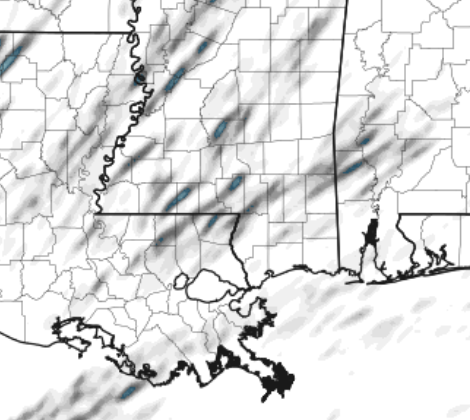
And remember that the UH Streaks are when we ask the computer to try to figure out where the strongest stroms may develop throughout the day. This isn’t a guarantee, by any means, but I look at it more as a good eyeball test. If tehre are a lot of lines, I can anticipate a good opportunity for some impactful storms.
The good news is that once this is all over late tonight and into tomorrow morning, we clear things out and get back to calmer weather for the weekend.
STAY UP ON THE LATEST WITH THE FORECAST, TRACK STORMS ON THE RADAR, AND GET ALERTS SENT TO YOU DIRECTLY FROM THE NWS ON THE NICKELBLOCK FORECASTING APP. DOWNLOAD THE APP (CLICK THE LINK AT THE END OF THE POST) HERE!
REGIONAL DAY TO DAY FORECAST
Today
Areas of dense fog this morning. Cloudy with storms possible this afternoon and evening. Some severe. Highs in the mid 70s. Southeast winds 10 to 15 mph with gusts up to 25 mph. Chance of rain 60 percent.
Tonight
Showers with thunderstorms likely. Some severe. Lows in the upper 50s. South winds 15 to 20 mph with gusts up to 30 mph. Chance of rain 90 percent.
Thursday
Mostly cloudy with lingering showers in the morning possible. Highs in the mid 60s. Northwest winds 10 to 15 mph, diminishing to around 5 mph in the afternoon. Chance for rain around 30 percent.
Thursday Night
Mostly cloudy with a few lingering showers possible. Lows around 50. North winds around 5 mph. Chance of rain 20 percent.
Friday
Mostly cloudy. Highs in the lower 60s. Northwest winds 5 to 10 mph.
Friday Night
Mostly cloudy. Lows in the upper 30s.
Saturday
Partly sunny in the morning, then clearing. Cooler with highs in the lower 50s.
Saturday Night
Mostly clear. Cold with lows in the lower 30s.
Sunday
Sunny. Highs around 60.
Sunday Night
Mostly clear. Lows in the upper 30s.
Monday
Mostly sunny. Highs in the upper 60s.
Monday Night
Mostly cloudy. Lows around 50.
Tuesday
Mostly cloudy with a 40 percent chance of showers. Highs around 70.


